
Hailuoto
| coat of arms | map |
|---|---|

|

|
| Basic data | |
| State : |
|
| Landscape : | Northern Ostrobothnia |
| Administrative community : | Oulu |
| Geographical location | 65 ° 0 ′ N , 24 ° 43 ′ E |
| Surface: | 1,082.70 km² |
| of which land area: | 200.52 km² |
| of which inland waterways: | 1.70 km² |
| of which sea area: | 880.48 km² |
| Residents : | 974 (December 31, 2018) |
| Population density : | 4.9 inhabitants / km² |
| Municipality number : | 072 |
| Language (s) : | Finnish |
| Website : | www.hailuoto.fi |
Hailuoto [ ˈhɑi̯luɔtɔ ], in Swedish Karlö , is an island in the Gulf of Bothnia west of the city of Oulu . It has a diameter of about 35 km and is inhabited by 974 people (as of December 31, 2018). Hailuoto forms a separate municipality in the Finnish landscape of Northern Ostrobothnia .
About a third of the island is a bird sanctuary . It can be reached from the mainland with a ferry that is part of the general road network and therefore free of charge from the travel port of Riutunkari in Oulunsalo . In some years the sea is frozen over in winter and you can drive to the island on an officially certified ice road from around December to March. Today, Hailuoto is the only year-round Finnish island north of Åland that has no fixed connection with the mainland.
The island's natural vegetation consists mainly of pine and birch and is rather limited due to the very low rainfall (approx. 300 mm per year). However, the sparse coniferous forests of Hailuoto provide good soil for natural berries. The pure sandy soil, which is poor in plants due to the drought, also enables lichen to grow .
history
Hailuoto began to form from some sandbanks about 2000 years ago as a result of the postglacial land uplift . The still small island was settled by fishermen at the beginning of the second millennium, who named their new place of residence Haililuoto ( Eng . " Herring Archipelago " ) after the most common type of fish caught.
Despite its separate location from the mainland, Hailuoto attracted new residents with fishing and hunting opportunities and the mild, almost frost-free climate during the growing season . Many new settlers came from the eastern Finnish-speaking areas at the same latitude, even from White Karelia , where agriculture was often hampered by frost.
Until about 200 years ago, Hailuoto was in three islands, the main island Luoto (Eng. "Small island" or "skerries" ), rich in birds, separated by Kirkkosalmi ( Eng . "Kirchensund" ) Hanhinen ( Eng . "Gänseland") ) in the southeast and the Santonen sandbank in the east. The land elevation has connected the parts in such a way that even Santonen, now a headland, has been navigable for about 60 years even during floods. The travel port is now in the eastern tip of Huikku of Santonen.
The oldest continuously used wooden church in Finland was on the island until 1968. This church, built in 1620 on the site of a medieval chapel and using its parts, with paintings by Christian Willbrandt (1659) including the free-standing baroque bell tower (1760), along with the remainder of the church archive from the fire in the rectory in 1901, probably burned through arson low. The new modern church (architects: Matti and Irma Aaltonen) next to the ruin dates from 1972 and was expanded in 2001.
Sea transport to the mainland
Regular sea traffic between Hailuoto and the mainland has existed since 1920. At that time, the HL Hailuoto cruise ship opened the daily connection to Oulu from the then port of Ulkokarvo , which is popularly known as Petsamo . The ship, which had crashed several times and sank once, was replaced as the main vehicle by the first ferry L / A Merituuli in 1968 and taken out of service in 1972. Today it is dry in Lumijoki and serves as a summer café.
The current main ferry L / A Merisilta is the third and the successor to the L / A Merilintu . Since 1996, the passenger ferry L / A Meriluoto has also served passengers in the high season. Due to the short distance, the ferries are not equipped with cabins (except storm cabins) or restaurants, but it is possible to stay on deck during the journey. The freely accessible WiFi panOulu is available to passengers on both ferries .
The distance between the travel ports of Riutunkari (Oulunsalo) and Huikku (Hailuoto) is around 8 km and the journey takes around 25 minutes. The ferries are free for all travelers. The year-round residents of the island have right of way on the ferry.
Ice road
The ice road , which is cleared in winter on the frozen sea between the travel ports of Oulunsalo and Hailuoto, is also a rare feature in Finland . When the ice cover has reached a certain thickness and load-bearing capacity, the ice road is opened to public traffic. Further prerequisites for the opening are sufficient evenness and the absence of cracks and water on the ice surface. When the ice road is in use, the ferry operates a limited number of times.
The ice road, like the ferries, is part of the general road network in Finland. Therefore, the general road traffic law and traffic insurance apply to it. The speed is limited to 50 km / h. The distances between the vehicles and the maximum permissible weight of the vehicles are also regulated with traffic signs.
economy
The residents of Hailuoto mainly work in the service sector and industry, of which the former has its high season with around 550 holiday homes and numerous shorter visits to the island in the summer. A last major investment in tourism in Hailuoto was the conversion of the pilot station in the western port of Marjaniemi into a tourist center.
The traditional forms of employment agriculture and fishing are still practiced by approx. 25% of the population. The once very important sheep farming with its large markets has almost completely disappeared. Hailuoto is famous for its pure and high quality braid, B. for gunpowder and decorative wreaths is collected.
Approx. 25% of employees are employed on the mainland, where they often also have a second home. The unemployment rate on the island is around 12%.
Villages in Hailuoto
Järventakusta, Kirkonkylä, Koivukylä, Marjaniemi, Ojakylä, Pöllä, Ulkokarvo, Vaski.
Other islands and skerries in the municipality of Hailuoto
Hoikanriisi, Isomatala, Kengänkari, Mustakivi, Santosenkari (Santos-Hoikka), Pikku-Hoikka, Ulkoriisi, Ulkolaidanmatala, Väliteonkarit.
Inland lakes on the island of Hailuoto
Haaralampi, Hannuksenlampi, Hannuksenrantalampi, Iso Sunijärvi, Kaakkurijärvi, Kangasjärvi, Kaunislampi, Kestinperä, Kurajärvi, Maasyvänlahti, Mäntylampi, Nuottajärvi, Pajuperänlampi, Väjuperänlampi, Pikku-Sunjärju, Vikkuenkjärjui, Pikku-Sunjärju, Vikku-Sunjärvi
Daughters and sons of the island
- Gustaf Skinnari (1835-1916), Finnish Lutheran hymn poet
- Anni Rapinoja (* 1949), Finnish artist
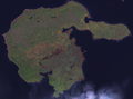
Hailuoto in the satellite image

Marjaniemi lighthouse in Hailuoto (1871)

Old cruise ship HL Hailuoto

Merisilta ferry

Meriluoto secondary ferry
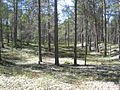
Coniferous forest with lichen in Hailuoto

New church in Hailuoto (1972) after expansion

Old wooden church of Hailuoto (1620), burned down in 1968

Building of the youth club in Hailuoto (1923)


Web links
Individual evidence
- ↑ Maanmittauslaitos (Finnish land surveying office): Suomen pinta-alat kunnittain January 1, 2010 . (PDF; 199 kB)
- ↑ Statistical Office Finland: Table 11ra - Key figures on population by region, 1990-2018
Alavieska | Haapajärvi | Haapavesi | Hailuoto | Ii | Kalajoki | Kärsämäki | Kempele | Kuusamo | Liminka | Lumijoki | Merijärvi | Muhos | Nivala | Oulainen | Oulu | Pudasjärvi | Pyhäjärvi | Pyhäjoki | Pyhäntä | Raahe | Reisjärvi | Sievi | Siikajoki | Siikalatva | Taivalkoski | Tyrnävä | Utajärvi | Ylivieska