Haapajärvi
| coat of arms | map |
|---|---|

|

|
| Basic data | |
| State : |
|
| Landscape : | Northern Ostrobothnia |
| Administrative community : | Nivala-Haapajärvi |
| Geographical location | 63 ° 45 ′ N , 25 ° 20 ′ E |
| Surface: | 789.17 km² |
| of which land area: | 765.49 km² |
| of which inland waterways: | 23.68 km² |
| Residents : | 7,147 (Dec 31, 2018) |
| Population density : | 9.3 inhabitants / km² |
| Municipality number : | 069 |
| Language (s) : | Finnish |
| Website : | haapajarvi.fi |
Haapajärvi [ ˈhɑːpɑjærvi ] is a town in Finland with 7147 inhabitants (as of December 31, 2018). It is located on the upper reaches of the Kalajoki River in the south of the Northern Ostrobothnian landscape .
In addition to the main town of Haapajärvi (around 3,700 inhabitants), it includes the villages of Ahola, Autioranta, Haaganperä, Jokela, Jämsänpuhto, Kalakangas, Kirkonkylä, Kiurunperä, Kontiopuhto, Kuona, Kuusaa, Kuusaa, Mustanperä, Mäntyperä, Parkava, Olkous , Tuomiperä, Varisperä, Vehkapuhto and Ylipää. In 1977 the municipality was granted city rights.
Haapajärvi is home to a campus for the economics faculty of the Middle Ostrobothnian Vocational College. Haapajärvi's sights include the wooden church , built in 1802, and a wooden house where the first Finnish President Kaarlo Juho Ståhlberg spent his childhood.
Haapajärvi is the terminus of a railway line to Jyväskylä ; there are also connections to Iisalmi and Ylivieska .
coat of arms
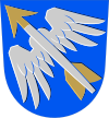
Description of the coat of arms : In a blue shield a silver winged arrow with a golden tip and fletching, placed diagonally upwards to the right .
Personalities
- Kristfrid Ganander (1741–1790), folklorist and philologist
- Juho Jaakonaho (1882-1964); Cyclist
- Mika Myllylä (1969-2011), cross-country skier
Individual evidence
- ↑ Maanmittauslaitos (Finnish land surveying office): Suomen pinta-alat kunnittain January 1, 2010 (PDF; 199 kB)
- ↑ Statistical Office Finland: Table 11ra - Key figures on population by region, 1990-2018