
Raahe
| coat of arms | map |
|---|---|

|

|
| Basic data | |
| State : |
|
| Landscape : | Northern Ostrobothnia |
| Administrative community : | Raahe |
| Geographical location | 64 ° 41 ′ N , 24 ° 29 ′ E |
| Surface: | 1,399.27 km² |
| of which land area: | 527.67 km² |
| of which inland waterways: | 8.22 km² |
| of which sea area: | 863.38 km² |
| Residents : | 24,811 (Dec. 31, 2018) |
| Population density : | 47 inhabitants / km² |
| Municipality number : | 678 |
| Language (s) : | Finnish |
| Website : | raahe.fi (engl.) |
Raahe [ ˈrɑːhɛ ] ( Swedish Brahestad [ ˈbrɑːhɛstɑːd ]) is a Finnish city on the Gulf of Bothnia . It belongs to the Northern Ostrobothnian landscape and, excluding the marine areas, covers an area of 535.65 km² , of which 8.34 km² is distributed over inland waters.
The city is best known for its well-preserved, historic wooden houses. The statue of the city's founder Per Brahe, created by Walter Runeberg in 1888, stands on the main square . Behind the square is the town church built in 1912 by Josef Stenbäck . The oldest diving suit in the world is on display in the local history museum . The asteroid (1786) Raahe is named after the city.
Population development
Development of the population (as of December 31) :
- 1990-18,328
- 2000-17,076
- 2002 - 16,569
- 2004 - 22,527
traffic
Raahe is connected to the Finnish rail network by the Tuomioja – Raahe line. Passenger traffic ceased in the autumn of 1966.
photos

Old town and church of Raahe
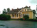
Raahe train station


Personalities
- Joonas Donskoi (* 1992), ice hockey player
- Heikki Kinnunen (born 1946), actor
- Janne Niinimaa (* 1975), ice hockey player
- Miikka Salomäki (* 1993), ice hockey player
Web links
Individual evidence
- ↑ Maanmittauslaitos (Finnish land surveying office): Suomen pinta-alat kunnittain January 1, 2010 . (PDF; 199 kB)
- ↑ Statistical Office Finland: Table 11ra - Key figures on population by region, 1990-2018
- ^ Raahe population 1985-2004
Alavieska | Haapajärvi | Haapavesi | Hailuoto | Ii | Kalajoki | Kärsämäki | Kempele | Kuusamo | Liminka | Lumijoki | Merijärvi | Muhos | Nivala | Oulainen | Oulu | Pudasjärvi | Pyhäjärvi | Pyhäjoki | Pyhäntä | Raahe | Reisjärvi | Sievi | Siikajoki | Siikalatva | Taivalkoski | Tyrnävä | Utajärvi | Ylivieska