Kuusamo
| coat of arms | map |
|---|---|

|

|
| Basic data | |
| State : |
|
| Landscape : | Northern Ostrobothnia |
| Administrative community : | Koillismaa |
| Geographical location | 65 ° 58 ′ N , 29 ° 10 ′ E |
| Surface: | 5,808.95 km² |
| of which land area: | 4,978.25 km² |
| of which inland waterways: | 830.70 km² |
| Residents : | 15,207 (Dec. 31, 2018) |
| Population density : | 3.1 inhabitants / km² |
| Municipality number : | 305 |
| Language (s) : | Finnish |
| Website : | kuusamo.fi |
Kuusamo [ ˈkuːsɑmɔ ] is a city in northeastern Finland with 15,207 inhabitants (as of December 31, 2018). Outside the city center, which is home to around 11,000 people, the area of Kuusamo is extremely sparsely populated, with a total area of 5,809 square kilometers. Because of its nature and the Ruka ski center , Kuusamo is one of the most important tourist centers in Finland. The city is known internationally as a venue for winter sports events.
geography
Position and extent
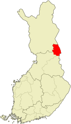
Kuusamo is located in the east of the North Ostrobothnian landscape on the border with Russia . The neighboring communities of Kuusamo are Suomussalmi in the south, Taivalkoski and Posio in the west, Salla in the north and, on the Russian side, Pjaosjorski in the east. The nearest major cities are Rovaniemi 192 kilometers northwest and Oulu 215 kilometers southwest. The distance to the capital Helsinki is 796 kilometers.
The region in which Kuusamo is located is traditionally referred to as Koillismaa (literally: "Northeast Country"). In addition to Kuusamo, the communities Taivalkoski , Posio and Pudasjärvi are historically part of Koillismaa . However, only Kuusamo and Taivalkoski belong to the official administrative community ( seutukunta ). Although the Lapland landscape only begins north of Kuusamo, the place is often unofficially assigned to Lapland, not least for reasons of tourist marketing.
Kuusamo covers an area of 5,809 square kilometers, of which 831 square kilometers are water. This means that Kuusamo is more than twice the size of the state of Luxembourg . The community center of Kuusamo, in which almost two thirds of the population live, only takes up a small part of the area. The rest of the area consists of the sparsely populated, mostly forested surrounding area. Therefore, the population density of Kuusamo is only 3.05 people per square kilometer of land. In addition to the city center, Kuusamo also includes the villages of Alakitka, Heikkilä, Hiltunen, Irni, Jokilampi, Kallunki, Kantokylä, Kemilä, Kero, Kesäniemi, Kiitämäjärvi, Koskenkylä, Kuolio, Kurvinen, Kärpänkylä, Pasoussukylä, Pasoussylä, Lämsänkylä, Lämsänkylä Rukajärvi, Määttälänvaara, Soivio, Suorajärvi, Tammela, Teeriranta, Törmäsenvaara, Vasaraperä, Virrankylä, Vuotunki, Lehto and Kiviperä.
Landscape and nature
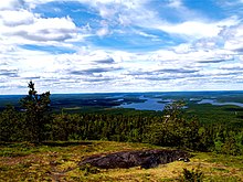
Scenic Kuusamo belongs to the metropolitan area of the Finnish hill country ( Vaara-Suomi ) that here already in the typical Lapland Fjell passes -Landscape. The urban area is located on a plateau around 250 meters high, from which the waters flow in five directions. In the area of Kuusamo there are numerous hills ( Finnish : vaara ) and fells (Finnish: tunturi ), which tower above the relatively low tree line here . The highest peaks are Valtavaara (492 meters), Kuntivaara (481 meters), Iivaara (469 meters) and Rukatunturi (462 meters) with the Ruka ski center .
90 percent of Kuusamo's land area is forested. Pines dominate the trees (70 percent), while spruce trees (20 percent) and deciduous trees (10 percent) also grow in the forests . 801 square kilometers, that is 14 percent of Kuusamo's area, are covered by water. The largest of the 166 lakes in the Kuusamo area are Joukamojärvi , Kiitämä , Kitkajärvi , Kurkijärvi , Kuusamojärvi , Muojärvi and Suininki . The Oulankajoki , Kitkajoki , Kuusinkijoki and Pistojoki rivers flow east into the White Sea , the Iijoki flow west into the Gulf of Bothnia .
The 270 square kilometer Oulanka National Park is located in the area of Kuusamo and the northern neighboring municipality of Salla. The landscape is dominated by pine forests, the Oulankajoki and its tributaries with their sandbanks and rapids and, in the northern part, by extensive marshland . 30 species of mammals and 120 bird species live in the wilderness, including brown bears , golden eagles and sea eagles . Wolves and lynxes are less common. The rapids Kiutaköngäs, Taivalköngäs, Jyrävä, Niskakoski and Myllykoski are located at Oulankajoki. The Hossa National Park , which was inaugurated in the summer of 2017, is located on the southern municipal boundary to Suomussalmi . Among its attractions is the Julma Ölkky Canyon Lake with its rock faces up to 50 meters high.
climate


The climate in Kuusamo is cold-temperate and more continental than in the rest of Finland. The annual average temperature is −0.3 ° C, the annual precipitation 525 mm. The warmest month is July with an average temperature of +14.7 ° C. It is coldest in February with -13.2 ° C. The coldest temperature ever recorded in Kuusamo was −48.0 ° C. Kuusamo is one of the snowiest regions in Finland: around 200 days a year, from late October to mid-May, there is a closed snow cover that is 80–90 centimeters thick.
The center of Kuusamo is around 60 kilometers south of the Arctic Circle , so the seasons of lighting ( polar day and night ) play a major role. Northern lights occur roughly every third night from September to February .
history
Sami settlement
Originally, until the 17th century, the Kuusamo area was inhabited by semi-nomadic Sami . In the cold season they lived in the winter villages of Maanselkä and Kitka. In spring they moved to the rivers and in summer after the ice melted to the lakes to fish and pick berries and mushrooms, in autumn they hunted forest reindeer , bears and beavers . Besides fishing and hunting, the seeds earned their living by working with the on the coast of the Gulf of Bothnia resident Finns and the Karelians of the White Sea coast exaggerated fur trade.
As a Sami settlement area, Kuusamo was then part of the Kemi-Lappmark . Nominally, the area belonged to the Swedish province of Västerbotten , but Swedish rule was limited to collecting taxes. At the same time, the area, which was regarded as ownerless, was also taxed from Russia .
Swedish rule
Since the 15th century, Finnish fishermen based on the lower reaches of the Iijoki River have been using the fishing grounds of Kuusamos. They regularly made trips of a few weeks to Kuusamo, but because there were no floodplains in the area that could have supplied hay for the cattle, unlike the middle reaches of the Iijoki, they did not establish permanent settlements. It was not until the Swedish state granted all new settlers in Lapland tax exemption for 15 years in 1673 that settlers from Savo and Kainuu began to settle in Kuusamo. They practiced shifting cultivation and began to slash and burn the forests. This endangered the Sami life form, which is mainly based on hunting. The Sami population was assimilated or displaced by the Finnish settlers within a few decades. As early as 1718 there were only two Sami families living in Kuusamo who had already adopted the Finnish language.
The first parish in Kuusamo was founded in 1685. A provisional chapel was built in 1687 and the first church was built in 1695. From the end of the 17th century the area began to be named Kuusamo after Lake Kuusamojärvi . The exact etymology of the name is unclear, but a derivation from a Sami term for "spruce forest" is possible.
The Swedish-Russian border had already been drawn east of Kuusamo in the Peace of Teusina in 1595 , but it was far from being precisely defined and permeable. Due to the constant influx of new settlers, Kuusamo grew steadily in the 18th century. Agriculture, cattle and reindeer herding gradually took the place of shifting cultivation . Around 1770 Kuusamo had around 2,000 inhabitants. In 1775 Kuusamo was released from the Lappmark and added to the newly founded province of Oulu . Because of the increased population, a new, larger church had to be built between 1797 and 1804. At the beginning of the 19th century the population had already reached 3,000, but a famine in 1803 and a smallpox epidemic in the following year decimated the population again.
Russian rule
In 1809 Kuusamo, like all of Finland, came under Russian rule. In the first half of the 19th century, the area was hit several times by devastating famines and epidemics. After the catastrophic crop failure in 1867, Kuusamo was spared major famines and the population rose steadily. In 1886 over 7,000 people lived in Kuusamo, and in 1894 there were already 8,000. With the advent of forestry at the end of the 19th century, workers moved to the area, so that in 1910 Kuusamo had a population of 10,500. In 1868 the parish of Kuusamo was converted into a political municipality as part of the administrative reform of Finland.
Since independence
After Finland gained independence in 1917, the Russian border was closed and Kuusamo was cut off from its hinterland. Now no more timber could be floated from Kuusamo to the ports on the White Sea, which meant a significant setback for forestry. The reindeer industry also suffered from the fact that some of the animal populations had remained on the wrong side of the border. Therefore, agriculture developed into the most important economic factor in the period between the world wars. By 1925 the population rose to 14,634, but the next year it fell by around 2,000 when the villages of Posio and Suolijärvi separated from Kuusamo.
At the beginning of the Winter War , Kuusamo was evacuated in December 1939 for fear of a Soviet invasion. In the Peace of Moscow , which ended the Winter War on March 14, 1940, Finland had to cede large parts of Karelia as well as the eastern areas of Salla and Kuusamo to the Soviet Union. The ceded part of Kuusamo had an area of 1653 km² and included the villages of Paanajärvi, Tavajärvi, Vatajärvi, Enojärvi, Pukari and Kenttikylä. Its 2100 residents had to be relocated to other parts of Kuusamo. During the Continuation War from 1941 to 1944, German Wehrmacht soldiers were stationed in Kuusamo . Finland signed an armistice agreement with the Soviet Union in September 1944 . It had to undertake to drive the German troops out of the country in the later so-called Lapland War , and Kuusamo was again evacuated within a short time. The German troops quickly withdrew, but before that they destroyed a large part of the community; among other things, they burned down the church village.
In the years from 1945 to 1952, Kuusamo was rebuilt. The population increased until the mid-1960s. When agriculture was no longer able to offer enough jobs for the baby boom years, the population began to decline, which continues to this day, apart from a period of consolidation in the 1980s. The first ski slope was laid on the Rukatunturi as early as 1954 . With the expansion of Ruka into a ski sports center, Kuusamo subsequently developed into a tourist center and is now the main branch of industry. In 2000 the municipality of Kuusamo received city rights.
population
On December 31, 2019, Kuusamo still had 16,134 residents. About two thirds of the population lives in the city center, the so-called church village of Kuusamo, the rest is distributed among the villages in the rural area. Like most communities in the structurally weak north and east of Finland, Kuusamo is affected by the migration to the metropolitan areas of southern Finland. In the mid-1960s, the population peaked at almost 21,000. After an initial phase of decline, the number of inhabitants consolidated again in the 1980s, and has been falling again since the mid-1990s.
The negative population development is also reflected in the age structure of Kuusamo, because it is mainly young people who are leaving the city. Between 1998 and 2001 the proportion of 0–15 year olds in the population fell from 25 to 23 percent, while the proportion of over 64 year olds rose from 12 to 14 percent.
| year | population |
|---|---|
| 1960 | 18,639 |
| 1965 | 20,795 |
| 1970 | 19,974 |
| 1980 | 18,161 |
| 1985 | 17,923 |
| 1990 | 18,061 |
| 1995 | 18,687 |
| 2000 | 17,891 |
| 2005 | 17.113 |
| 2010 | 16,492 |
| 2015 | 15,688 |
| 2017 | 15,368 |
politics
City council
As is customary in northern Finland, the Center Party is the dominant political force in Kuusamo. In the 2017 local elections it received almost 58 percent of the votes after slight gains, and it has 24 members in the city council, which has been reduced to 39 seats (43 seats in the 2012-2017 electoral period). The two other major parties in the country, the conservative National Assembly Party and the Social Democrats, play a subordinate role with five and two seats on the city council. The Green Bund, which now has four members , is receiving steadily growing approval . Also represented in the city council are the right-wing populist Die Finns with two seats and the left-wing alliance , also with two MPs. The turnout was average at 62.9%.
| Political party | Election result 2017 | Seats |
|---|---|---|
| Finnish Center Party | 57.7% (+2.9) | 24 (−1) |
| Green covenant | 11.9% (+4.2) | 4 (+1) |
| National rally party | 11.7% (± 0) | 5 (± 0) |
| Finns | 6.4% (−5.4) | 2 (−3) |
| Social democrats | 6.1% (−2.2) | 2 (−1) |
| Left alliance | 4.9% (+0.3) | 2 (± 0) |
| Christian Democrats | 1.2% (+0.2) | 0 (± 0) |
coat of arms
The coat of arms of Kuusamo was designed in 1959 and shows a silver reindeer under a golden polar light in a red shield. In addition, the city of Kuusamo uses an official logo, which consists of the red Kuusamo lettering under a golden aurora borealis.
Town twinning
Kuusamo maintains the following cities a twinning :
-
 Avesta , Sweden , since 1984
 -
 Hørning , Denmark , since 1988
 -
 Askøy , Norway , since 1988
 -
 Louchi , Republic of Karelia , Russia , since 1989
Economy and Infrastructure
economy
The main industries in Kuusamo are tourism , forestry and agriculture , reindeer herding and small-scale industry. The unemployment rate is relatively high at 9.3 percent (June 2019).
In 2002 there were 248 farms in Kuusamo. Due to the climatic conditions, hardly any grain is grown, whereas milk and meat production play a major role. Reindeer herding is another major industry . Around 10,000 reindeer live in the forests of Kuusamo and roam free in summer. In late autumn, their owners round up the animals, pick out the animals for slaughter and mark the young. The forestry and wood processing industry employ over 1,000 people in Kuusamo.
tourism
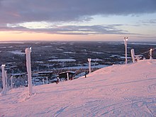
Kuusamo is one of the most important tourist areas in Finland. In total, around one million tourists visit Kuusamo every year. In 2002, 291,222 overnight stays were registered, 17 percent of them from foreign guests. There are around 6,000 holiday homes ( mökki ) in the city area , more than in any other municipality in Finland. The Ruka ski center is the largest in Finland with a total of 16,000 beds, four hotels and 28 restaurants. On the slopes of the 492 m high Rukatunturi there are 29 mostly illuminated slopes. Guests can also enjoy activities such as cross-country skiing, snowmobile rides or trips with reindeer and dog sleds . Ruka benefits from the long ski season, which lasts from the beginning of October to mid-May. In summer, Kuusamo is primarily a destination for nature tourists who come to the area for fishing, kayaking or hiking. The most famous hiking route is the Bear Tour ( Karhunkierros ), which leads 82 km from Ruka through the Oulanka National Park to Hautajärvi in the municipality of Salla .
traffic
State road 5 , which runs in north-south direction through Finland and which also follows European route 63 , connects Kuusamo via Heinola with the south of the country and continues north towards Sodankylä . The state road 20 leads from Kuusamo to Oulu , the main road 81 to Rovaniemi . In Suoperä near Kuusamo there is a border crossing to Russia, which has also been open to international traffic since 2006. In 2007, 17,000 border crossings were recorded.
The Kuusamo airport is located 6 kilometers by road from the city center and 27 kilometers from Ruka. It was created in 1969 and has been expanded several times since then. The airline Finnair offers daily direct flights from Helsinki, during the tourist season also control charter flights to Kuusamo. In 2007, 108,394 passengers used the airport.
To the rail network Kuusamo was only briefly in the 1940s with the railway Hyrynsalmi-Kuusamo connected. Today the nearest train station with passenger traffic is in Kemijärvi, 140 kilometers away .
Culture and sights
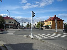
While Kuusamo attracts visitors mainly because of its natural beauty, the city has few sights in the traditional sense. Because the city center was completely destroyed in the Lapland War and then had to be rebuilt as quickly and economically as possible, Kuusamo is largely uninteresting from an architectural point of view. In contrast, the city's cultural life is relatively lively, at least in view of the small number of inhabitants.
The "Kuusamo House" in the city center, completed in 1996, functions as a culture and congress center. Music and theater performances as well as changing art exhibitions take place here on a regular basis. The Kuusamo Museum of Local History is an open-air museum set up in a historic farm. There is also a school museum in the old school in Kirkkoketo.
The church in the center of Kuusamo was built in 1951. It stands on the site of the old wooden church from 1802, which was burned down by German troops in the 1944 Lapland War . At that time, German soldiers buried the two church bells - the Swedish King Karl XI had one. Donated in 1698, the other from 1721 - in the cemetery to protect it from the approaching Soviet troops. The bells were considered lost until 1959 when the former German regimental commander visited Kuusamo and revealed the location of the buried bells.
Sports

Kuusamo has become known in terms of sport through the Ruka winter sports center , which is only around 25 kilometers from the city, see also Sports in Ruka .
See also : Winter Sports World Cup in Kuusamo
Web links
Individual evidence
- ↑ Maanmittauslaitos (Finnish land surveying office): Suomen pinta-alat kunnittain January 1, 2010 (PDF; 199 kB)
- ↑ Statistical Office Finland: Table 11ra - Key figures on population by region, 1990-2018
- ↑ Compare, for example, the internet portal kuusamolapland.fi (English)
- ↑ Metsänhoitoyhdistys Kuusamo ( Memento of the original from December 14, 2007 in the Internet Archive ) Info: The archive link was inserted automatically and has not yet been checked. Please check the original and archive link according to the instructions and then remove this notice. (Finnish)
- ↑ Animals in Oulanka ( Memento of the original from June 5, 2011 in the Internet Archive ) Info: The archive link was inserted automatically and has not yet been checked. Please check the original and archive link according to the instructions and then remove this notice. (Finnish Forest Service, English)
- ↑ Hossan kansallispuisto - Luontoon.fi. Retrieved September 22, 2017 (Finnish).
- ↑ Software: Geoklima 2.1
- ^ University of Oulu (ed.): Climate archive of the Oulanka research station .
- ↑ a b Kuusamo Taskutieto ( Memento of the original from September 27, 2007 in the Internet Archive ) Info: The archive link was inserted automatically and has not yet been checked. Please check the original and archive link according to the instructions and then remove this notice. (Info brochure of the city of Kuusamo, Finnish)
- ↑ http://pxnet2.stat.fi/PXWeb/pxweb/en/StatFin/StatFin__vrm__vaerak/statfin_vaerak_pxt_11ra.px/
- ↑ Finnish Ministry of Justice: Result of the 2017 local elections
- ↑ http://pxnet2.stat.fi/PXWeb/pxweb/en/StatFin/StatFin__tym__tyonv__kk/statfin_tyonv_pxt_1001.px/?rxid=d90ed3de-4ff0-4150-8bde-7a9a79d61a09
- ↑ Finnish border guards: Rajanylitysmäärät itärajan rajanylityspaikoilla (number of border crossings at the border crossings of the eastern border, Finnish)
- ↑ Finavia ( Memento of the original from June 19, 2008 in the Internet Archive ) Info: The archive link was inserted automatically and has not yet been checked. Please check the original and archive link according to the instructions and then remove this notice. (English)


