Hattingen-Mitte
Hattingen-Mitte is a district of Hattingen . As of December 31, 2016, 20,127 people were registered in an area of 6.54 km². It is therefore the most populous part of the city.
description
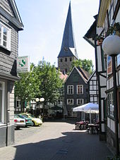
The district includes the medieval old town , once enclosed by a city wall, with the old town hall and the churches of St. Georg and the churchyard as well as St. Johannis (only the bell tower has been preserved) at Krämersdorf.
The New Town Hall (1910) is located in the urban expansion of the city center to the northeast up the hill . A second city expansion leads down to the Ruhr , where the Hattingen train station (1869) was built, which is now served by the S 3 . Since 1994 it has ended near the old town in Hattingen Mitte . The bus station is also nearby. The Ruhrbrücke Hattingen with the tram 308 to Bochum leads the B 51 , which is stepped to the state road, over the river. In the south to the Schulenberg lies the Bruchfeld with its workers' settlements.
In the post-war period, the residents managed to prevent the renovation of the area. The half-timbered houses were renovated and today they create an attractive and tourist-interesting ambience. Heggerstrasse became the first part of a pedestrian zone . The shopping center, formerly Karstadt, represents a stylistic break .
See also
Web links
Individual evidence
Coordinates: 51 ° 24 ' N , 7 ° 11' E

