
Heinzwinkel
|
Heinzwinkel
Community of Schönheide
Coordinates: 50 ° 29 ′ 56 ″ N , 12 ° 30 ′ 42 ″ E
|
||
|---|---|---|
| Height : | 700 m | |
| Postal code : | 08304 | |
| Area code : | 037755 | |
Location of Heinzwinkel in Saxony |
||


The Heinzwinkel is a part of the municipality Schönheide ( Erzgebirgskreis ) in the westernmost tip of the Saxon Ore Mountains .
location
This district is located in the south-western part of Schönheide, is accessed through Wiesenstrasse and has around 30 residential buildings, half of which are dachas . South-south-east of the Heinzwinkel district rises a mountain, popularly known as Schuchhübel , which, at 727.9 meters, towers over the neighboring Baumannsberg and Knock mountains east of the Heinzwinkel (both of which are 725.5 meters high). However, unlike the two lower mountains mentioned, it is entered on maps without a name and only with its height. Nevertheless, the Schuchhübel is the highest of the nearby mountains south of Schönheide to the Zwickauer Mulde .
According to the natural space map of Saxony , the area lies in the mesogeochore "Schönheider plateau" and belongs to the microgeochore "Schönheider Kuppengebiet".
Surname


The author Ernst Flath, who wrote a story of Schönheide published around 1909, considers the first part of the name Heinzwinkel to be the name of the first settler. Sheet 195 of the Meilen Blätter von Sachsen in the Berlin edition of 1791 shows a small group of houses in the west of Schönheide with the name “Hayns Winckel” . The Saxon equidistant map from 1876 uses the name "Heinzewinkel" . "Winkel" as a name for a district is used several times in the municipality of Schönheide: Ascherwinkel , Fuchswinkel , Heinzwinkel, Schwarzwinkel (formerly Marquartswinkel). Siegfried Sieber calls this term an old field name. This is confirmed in the German dictionary of the Brothers Grimm , according to which the term "angle" "is often to be found in place and field names to designate pieces of land that bend in between mountains, forests and river bends" .
History and settlement development
The beginning of the settlement of Schönheide is dated to 1537. In the founding deed for Schönheide, the so-called liberation letter of March 20, 1549 jul. of Balthasar Friedrich Edler von der Planitz , the location of the double hooves is described as reaching on the one hand from the Dorfbach north to the Filzbach and on the other hand south to the Zwickauer Mulde . The twenty hooves of the founding phase reached from the eastern edge of the village to about the source area of the village stream. The area further to the west and higher up, as far as it was forested, was initially not cleared and was not used for agriculture as a raised bog . This also applies to the area of the later district of Heinzwinkel. It is unclear when it began to be settled in the course of the further development of the village of Schönheide. In 1836 the new alphabetical index of places of the Kingdom of Saxony describes the Heinzwinkel as “Ortstheil” and “is a separate group of houses belonging to the Commun Schönheida” . There is no information in the columns number of residential buildings and inhabitants . In his work Description of Saxony, published in 1840, Albert Schiffner counts the "Heinzwinkel" as one of Schönheide's remote groups of houses . Because the district "Heinzewinkel" was "isolated from the actual complex of the more closely built village at a greater distance and built in a more dispersed manner", it was exempted from the ban on shingle, thatch and cane roofs, which in Saxony " and in the country "by the" Ordinance, building control measures to avert the risk of fire relating to March 11, 1841 "was introduced. In 1846 the district is described as belonging to Schönheide. Around 1848 Albert Schiffner mentions the district in his work "Führer im Muldenthale", he belongs to the "groups of houses that are scattered in the side canyons and on the heights".
Until after the Second World War there were only a few small farms. During the GDR era, around 15 dachas were built on the western edge of the property.
Natural area

Area 1 of the Natura 2000 area " Mountain meadows around Schönheide and Stützengrün " ( SCI - German registration number 5441-303) borders the development of the district . This is a 6.3 hectare natural area of European importance . It is located to the west and south of the Heinzwinkel district. The area extends down the slope to the Tannenbach. In the northern part it comprises “various complexes of mountain meadows and lean biotopes such as grass grass, open rock corridors / rock formations as well as mountain and rock heath” and in the southern part “various complexes of mountain meadows and wet biotopes such as wet meadows, Kleinseggenrieder, reed beds, z. Partly with near-natural low mountain range and near-natural perennial small water ”. As a habitat type according to the Habitats Directive , mountain hay meadows (habitat type 6520) in the northernmost part were found to be in a good state of conservation, followed to the south by mountain hay meadows in a medium to poor state of conservation, and further to the south a broad strip in an excellent state of conservation follows. The majority of the FFH core area, in particular the large southernmost part, was assessed as being in good state of preservation in the course of the mapping. In this southern part there are two areas with "field trees, bushes, hedges". At the edge of the Tannenbach valley floor there is the type 6230 - species-rich borst grass lawn, which is classified as a "priority habitat type" in the Habitats Directive because of its rarity . The mapping showed that it was in "excellent condition" in 2011.
The Erzgebirgskreis put the mountain meadow sloping down towards the Tannenbach under protection as an area natural monument . This is indicated by a sign on the edge of the road. Meaning and protection notices are not given.
gallery
- Heinzwinkel in historical maps and at the beginning of the 21st century

1876: Heinzewinkel

Wiesenstraße as a narrow development
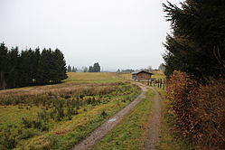
Farming land - today partially forested

1791: Hayns Winckel

Old barn with a high entrance
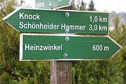
Heinzwinkel as a hiking destination

Small barn with a half-cellar

Small pond farm on the western slope

Agricultural implements that are no longer used


literature
- Ernst Flath: Local history and history of Schönheide, Schönheiderhammer and Neuheide . Schönheide o. J. (1909), reprint 1992.
- Ernst Flath: The history of the founding of Schönheide - for the upcoming four-centenary of the place . In: Glückauf! Journal of the Erzgebirgsverein No. 5/1937, pages 65–70.
- Ernst Flath: From the history of our hometown , in: Heimatgeschichtliche Festzeitung. Festive supplement to the Schönheider Wochenblatt of August 21, 1937 on the occasion of Schönheide's four-centenary
Web links
- "Hayns Winckel" on sheet 194 of the Meilen Blätter von Sachsen - Berlin copy from 1791 ( link to the digitized version in the Dresden State and University Library )
- “Der Heinz Winkel” on sheet 19-Schwarzenberg- from 1843 in: Topographical Atlas of the Kingdom of Saxony, Second delivery, containing the sections Freyberg, Schwarzenberg, Zittau and Weissenberg by Jakob Andreas Hermann Oberreit ( link to the digitized version in the Dresden State and University Library )
- "Heinzewinkel" on sheet 136 - Section Schneeberg - the Saxon equidistant map on a scale of 1: 25,000 from 1876 ( link to the map sheet in the Saxon State and University Library )
- "Heinzwinkel" in sheet 136 - Section Schneeberg - the Saxon equidistant map in the scale 1: 25,000 from 1905 ( link to the map in the Dresden University Library )
- "Heinzwinkel" in sheet 70-136 Section Schneeberg of the topographical map ( measuring table sheet ) on a scale of 1: 25,000 from 1916 ( link to the map sheet in the Saxon State and University Library )
- "Heinzwinkel" in sheet 5441 - Schneeberg - the topographic map (measuring table sheet) 1: 25,000 from 1942 ( link to the map sheet in the Saxon State and University Library )
Remarks
- ↑ The directory of the community of Schönheide on the new house numbers assigned from January 1, 1975 contained 26 house numbers for Wiesenstrasse.
Individual evidence
- ↑ House number directory of the community Schönheide for the Wiesenstraße
- ↑ Topographic map 5541-NW-Wilzschhaus of the Land Surveying Office Saxony, 1st edition, Dresden 1996
- ↑ Natural space map service of the Landschaftsforschungszentrum eV Dresden ( information )
- ↑ Ernst Flath: Local history and history of Schönheide, Schönheiderhammer and Neuheide , Schönheide o. J. (1909), p. 5 Digitized in the State and University Library Dresden
- ↑ Sheet 195 from Meilenblätter von Sachsen, Berlin copy , accessed on November 30, 2014
- ↑ Sheet 136 - Section Schneeberg - the topographic map (equidistant map) Saxony, edited in the topographic bureau of the Royal General Staff - 1: 25000. Year 1876 ( digitized in the Dresden State and University Library )
- ↑ a b The mining landscape of Schneeberg and Eibenstock (= values of the German homeland . Volume 11). 1st edition. Akademie Verlag, Berlin 1967, p. 104.
- ^ Jacob Grimm, Wilhelm Grimm: German Dictionary , Volume 30, Sp. 347 lit. B No. 1 c Digitized in the dictionary network , accessed on February 12, 2015. See also Matthias Lexer: Mittelhochdeutsches Wörterbuch , Volume 3, Sp. 904–906 Digitized in the dictionary network , accessed on January 30, 2015
- ↑ Ernst Flath: Local history and history of Schönheide, Schönheiderhammer and Neuheide , Schönheide o. J. (1909), p. 177 Digitized in the Dresden State and University Library
- ^ Karl Gottlob Dietmann : The entire ... priesthood in the Electorate of Saxony ... Volume I.3: Konsistorium Wittenberg. Richter, Dresden, Leipzig 1755, p. 609 ( online ).
- ^ Ernst Flath: Local history and history of Schönheide, Schönheiderhammer and Neuheide , Schönheide o. J. (1909), p. 178 ( digitized in the Dresden State and University Library )
- ^ Ernst Flath: Local history and history of Schönheide, Schönheiderhammer and Neuheide , Schönheide o. J. (1909), p. 191 Digitized in the State and University Library Dresden
- ^ New alphabetical index of places of the Kingdom of Saxony. Compiled according to official reports by the Central Committee of the statistical association for the Kingdom of Saxony. With the most gracious privilege granted. , First department A.–L., Verlag der Waltherschen Hofbuchhandlung, Dresden 1836, p. 108 ( digitized in the Google book search)
- ^ Albert Schiffner: Description of Saxony and the Ernestine, Reuss and Schwarzburg lands . With 192 views and 2 maps, J. Scheible's Buchhandlung, Stuttgart 1840, p. 305 ( link to the digitized version in the Saxon State and University Library in Dresden )
- ↑ Gottlob Leberecht Funke: The police laws and ordinances of the Kingdom of Saxony, with the epitome of the organic and formal provisions , Volume V, Hahn'sche Verlagsbuchhandlung, Leipzig 1856, p. 345 digitized
- ^ Rudolf von Trautzschen: The building laws and building regulations of the Kingdom of Saxony , FA Brockhaus, Leipzig 1859, p. 288 digitized
- ↑ Eugen Huhn: Topographical-statistical-historical lexicon of Germany, a complete German regional, folk and political history . Third volume, Druck und Verlag des Bibliographisches Institut, 1846, p. 50 digitized version , accessed April 1, 2015
- ^ Albert Schiffner: The leader in the Muldenthale, from the Voigtlands heights to the union of the two hollows . In 16 deliveries, containing 37 views, taken from nature by Gustav Täubert, lithographed by J. Riedel, Verlag von Gustav Täubert, Dresden (no year, 1848), p. 12 ( link to the digitized version in the Leipzig University Library p. 12 cannot be called up directly, scroll through the digitized version or click on "Schönheide" in the table of contents on the left.)
- ↑ Management plan for the FFH area 5441-303 - State registration number 286 "Mountain meadows around Schönheide and Stützengrün" , Office for Landscape Ecology and Landscape Planning Uwe Fischer, Schwarzenberg 2012, p. 11
- ↑ a b Management plan for the FFH area 5441-303 "Mountain meadows around Schönheide and Stützengrün" , Office for Landscape Ecology and Landscape Planning Uwe Fischer, Schwarzenberg 2012, Map 1 / Sheet 2 - Biotope types and land use
- ↑ Map at the Federal Agency for Nature Conservation . Area to the west of the Heinzwinkel location
- ↑ a b Management plan for the FFH area 5441-303 "Mountain meadows around Schönheide and Stützengrün" , Office for Landscape Ecology and Landscape Planning Uwe Fischer Schwarzenberg 2012, Map 2 / Sheet 2 - Selective biotope mapping
- ↑ Management plan for the FFH area 5441-303 "Mountain meadows around Schönheide and Stützengrün" , Office for Landscape Ecology and Landscape Planning Uwe Fischer, Schwarzenberg 2012, Map 3 / Sheet 2 - Representation and evaluation of habitat types and habitats

Old meadow house | Ash angle | Baumannsberg | Book height | Fox Angle | Heinzwinkel | Neuheide | Red Mill | Schadlichsberg | Schönheiderhammer | Black angle | Uttmanns Vorwerk | Webersberg | Wilzschhaus | Ziegenleithe