
Ash angle
|
Ash angle
Community of Schönheide
Coordinates: 50 ° 30 ′ 13 ″ N , 12 ° 30 ′ 25 ″ E
|
||
|---|---|---|
| Height : | 700 m | |
| Postal code : | 08304 | |
| Area code : | 037755 | |
Location of Ascherwinkel in Saxony |
||


The Ash angle is a district of the western tip of the Saxon Erzgebirge commune in Schönheide ( Ore Mountains ).
location
The district of Ascherwinkel is located in the western part of Schönheide at the end of the main road that runs through the entire village from east to west on an area that rises only slightly at an altitude of about 700 m above sea level. NN without significant valley cuts. It is the closest district of Schönheide to the Vogtland. According to the natural space map of Saxony , the area lies in the mesogeochore "Schönheider plateau" and belongs to the microgeochore "Schönheider Kuppengebiet". To the north-west is the “Kuhberg-Ridge” microgeochore. The Ascherwinkel is also accessed through Carolagrüner Strasse, Fabrikgasse, Quergasse, Waldstrasse, Weidmannsweg and partly through Angerstrasse. There is no clear demarcation from the upper part of Schönheide called Oberdorf in view of the continuous development. Neuheider Strasse and the north-south part of Angerstrasse can be seen as the eastern border of the Ascherwinkel. The district has around 200 houses and other larger buildings.
Surname


In the first part of the name Ascherwinkel, the author Ernst Flath, who wrote a story by Schönheide that appeared around 1910, considers it possible that the word ash is related to the peat that was extracted from the raised bog there. Sheet 196 of the Meilen Blätter von Sachsen in the Berlin copy from 1791 does not yet have an entry with the name Ascherwinkel. The equidistant map from 1876 uses the name "Ascherwinkel" . As a name for a district, there are "Winkel" in the municipality of Schönheide several times: in addition to Ascherwinkel also Fuchswinkel , Heinzwinkel , Schwarzwinkel (formerly Marquartswinkel). Siegfried Sieber calls this term an old field name. This is confirmed in the dictionary of the Brothers Grimm, according to which the term “angle” “is often to be found in place and field names to designate areas of land that bend between mountains, forests and river bends” . Moritz von Süßmilch used the name Ascherheide in 1894 . This is possibly a confusion with Hohe Heide , which is shown in older maps as being nearby. All maps and other publications use the term ash angle .
Geomorphological conditions
In a raised bog of almost 3 hectares with a thickness of up to 3 meters, peat was extracted until the end of the 19th century. In a map from 1876 the bog area is entered and the mining is marked with peat cutting . The peat deposits "bey Schönheyde" are reported as early as 1777. In the Ascherwinkel rises at an altitude of about 705 m above sea level. NN the Tannenbach, which after a run of almost four kilometers below Wilzschhaus at 585 m above sea level. NN flows into the Zwickauer Mulde. The Holzbach rises on the southern slopes of the Kuhberg . It is the only brook with a name from the Schönheid municipality whose water does not flow into the Zwickauer Mulde, but into the Saale. To the west of the populated part of Ascherwinkel there are large forests that extend to the outskirts of the Auerbach district of Schnarrtanne. In these forests lies the Laubberg ( 767 m above sea level ), the highest mountain in Schönheid municipality.
History and Development
The beginning of the settlement of Schönheide is dated to 1537. In the founding document for Schönheide, the so-called letter of exemption from March 20, 1549 jul. of Balthasar Friedrich Edler von der Planitz , the location of the double hooves is described as reaching on the one hand from the Dorfbach north to the Filzbach and on the other hand south to the Zwickauer Mulde. The twenty hooves of the founding phase reached from the eastern edge of the village to about the source area of the village stream. The area further to the west and higher was initially not cleared, as far as it was forested, and not used for agricultural purposes as a raised bog . This also applies to the area of the later district of Ascherwinkel. It is unclear when it began to be settled in the course of the further development of the village of Schönheide. In 1836 the new alphabetical index of places of the Kingdom of Saxony describes the Ascherwinkel as "Ortstheil" and "belonging to Schönheide, and forms a separate group of houses from it" . There is no information in the columns number of residential buildings and inhabitants .
.jpg)
Because the district of Ascherwinkel was "separated from the actual complex of the more closely built village at a greater distance and built in a more dispersed manner", it was exempted from the ban on shingle, thatch and cane roofs, which in Saxony applies to cities and towns dem Land ”was introduced by the“ Ordinance, Building Police Regulations to Avoid Fire Danger of March 11, 1841 ”. In his work “Description of Saxony and the Ernestine, Reuss and Schwarzburg Lands”, published in 1840, Albert Schiffner counts the Ascherwinkel among the “remote groups of houses” of Schönheide. Around 1848 Albert Schiffner mentions the district in his work "Führer im Muldenthale", he belongs to the "groups of houses that are scattered in the side canyons and on the heights".
The development of the economy and of housing ran parallel to the development of the entire village: from a few farms to manufactories to industry and from small residential buildings to multi-family houses with an almost urban character. The multi-family houses were followed by single-family housing estates in the 1930s, which were supplemented by new buildings into the 21st century. In the 21st century the housing stock is likely to be several hundred.
- Labor service warehouse
A camp built from barracks for male employees of the Reich Labor Service with the camp number 3/165 existed during the time of National Socialism on the edge of the forest at the western end of the village, the same for female employees closer to the built-up location. Immediately after the end of World War II, the latter was used to accommodate refugees and displaced persons and, in the early GDR period, as accommodation for members of the barracked people's police . The police officers housed there had the task of guarding the borders of the area around Aue, which was closed due to uranium mining. Their service area was the restricted area border in Schönheiderhammer and Wilzschhaus . The barracks were later used as a children's holiday camp for the Fritz-Heckert-Werke in Karl-Marx-Stadt. The barracks in both camps were demolished. In the 1950s, a football pitch, now known as the Waldstadion, was built on the site of the camp for male labor service workers. The barracks used for the children's holiday camp were only demolished after 1970, after a hotel-like building had been built as a holiday home for the Fritz-Heckert-Werke at the western end of the village.
Economy and Infrastructure
Commercial enterprises
The brush industry emerged
Around 1820 the manufacture of brushes, brooms and paintbrushes began in the district of Ascherwinkel, which should lead in its development to Schönheide's main line of business in the 20th century. Siegfried Sieber describes the brush industry “of the Schönheider Winkel” in his studies on the industrial history of the Ore Mountains published in 1967 as “world famous”. In 1937 the postmark said “Schönheide - headquarters of the brush industry” on the postmark for the 400th anniversary. Gottlieb Henneberger and Christian Friedrich Flemming are considered to be formative for the development in the early stages. As early as 1831, the latter founded a brush manufacturing company in the Ascherwinkel district. This company grew even after Flemming's death in 1854, employed 100 workers in 1861, became a purveyor to the court in 1867 and, in the last quarter of the 19th century, became Schönheide's largest brush manufacturer. With a high level of vertical integration in the brush industry, the end products were manufactured from the raw materials, from the tree trunk to the raw bristles, in numerous operations and for this purpose sawmill, dyeing, laundry, drying and locksmithing were operated.
Business enterprise in the 21st century
The largest company is BÜMAG eG, a registered cooperative. It has been an association of 15 owner-managed brush manufacturers that has existed since 1989. In the Ascherwinkel district, BÜMAG operates a high-bay warehouse with 4,000 pallet spaces, which is combined with a 2,000 square meter high-speed warehouse. The specialization of the companies combined in the cooperative enables a large range that is sold from this central warehouse. The export share is 35%. Participation in trade fairs in Frankfurt, Cologne, Tokyo, Dubai, Hong Kong and Chicago, among others, should retain existing customers and enable new acquisitions. In the Ascherwinkel there are two companies in the area of the Erzgebirge craftsmanship . One of them mainly produces candle arches and Christmas pyramids , the other makes rotating chandeliers from the Ore Mountains. A company specializing in equipping libraries has its production facility in this district. The production facility of the sports shoe manufacturer Rass , which is known for its boots for ski jumpers , is located in the district of Ascherwinkel . Furthermore, there is the coating department of a steel and plant manufacturer, brush manufacturer, manufacturer of machines and plastic parts, companies trading in heating oil, agricultural and forestry equipment as well as craft businesses, a gas station with a car workshop, a bakery and two grocery stores. A special feature is a physiotherapy facility that also works with horses for therapy purposes.

Edge of the commercial area on Auerbacher Strasse

Information signs for commercial establishments

Agricultural buildings

Small-scale development in Fabrikgasse
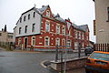
Urban development in the main street

Around 1910: Grocery store on Fabrikgasse

.jpg)


_in_Sch%C3%B6nheide_Handlung_von_F_Emil_Sch%C3%A4dlich_.jpg)
Leisure, recreation, tourism
The forest stadium, built around 1950, is over 700 meters above sea level on the edge of the woods. After the floods in 2002, this football stadium was renovated with flood remediation funds and equipped with an artificial turf pitch, which was renewed in 2018 for 240,000 euros by the municipality of Schönheide. For this purpose, she received 180,000 euros in funding from the “Bridges for the Future” program. The herbal nature trail in the Kuhberg area leads past the edge of the Ascherwinkel. The “Naturheilgarten” laid out by the Naturheilverein Schönheide from 1908 on property belonging to the municipality of Schönheide, also known as the “air bath” in older maps. is located in the district of Ascherwinkel on Gartenweg. His allotments, leased to members of the association, are still being cultivated in the 21st century. The hotel “Forstmeister”, which emerged from the company holiday home called “House of Friendship” of VEB Fritz Heckert-Werke in Chemnitz, is located on the outskirts at Staatsstrasse 277. In October 2019, after several years of closure, the “Hotel Carola” reopened with “Restaurant zur old lantern ”.
traffic
The district of Ascherwinkel is accessed by the state road 278, that of Auerbach / Vogtl. leads to Schönheide. The bus route V 81 connects Auerbach with Schönheide, in Ascherwinkel it serves the Auerbacher Straße and West stops . From the Ascherwinkel, the Carolagrüner Straße leads south-south-west in the direction of Carolagrün and Rautenkranz . In the beginning of the 21st century the street is still called Kiehwaach (Kühweg) in the Erzgebirge . As the "Kuhweg" (cow path), it is still entered on maps as a path leading to the Zwickauer Mulde. In sheet 236 of the Dresden copy of the Sächsische Meilenblätter from 1791 this street is referred to as "the Rautenkranzer Kühweg".
The International Mountain Hiking Trail of Friendship Eisenach-Budapest leads through the Ascherwinkel, as does the 11th stage of the Vogtland Panorama Trail .
The narrow-gauge railway Wilkau-Haßlau-Carlsfeld , operated from 1893, crossed the Ascherwinkel, the trains stopped at Oberschönheide station , which was called Schönheide West station from 1950 . In 1885, Karl Eduard Flemming referred to the Saxon state parliament for the continuation of the narrow-gauge railway Wilkau-Haßlau-Saupersdorf to Oberschönheide. The construction of the railway line was discussed several times in the Saxon state parliament, for example in 1886, whereby the importance of industry was emphasized. During the consultation in 1888, members of parliament spoke out in favor of the route through Oberschönheide, arguing that the “high importance of its production” deserved the “connection position”. With the commissioning of the railway line in 1893, a siding to the Flemming brush factory was laid. In the 1970s, the railroad stopped operating. Since 1994 the Schönheide Museum Railway has been operating the section between Schönheide and the Stützengrün stop again. Plans to extend the museum route to Wilzschhaus and thus reactivate Oberschönheide train station were partially implemented with ABM work as early as the early 1990s through clearing of the track area, but the track and, above all, bridge construction did not occur. The station building was demolished in 1999. A siding led from the railway line to the former Flemming brush factory, which was known as VEB Flamingo as a state-owned company during the GDR era . The siding was of great importance for the railway line. More than 10% of the freight traffic on the entire route was handled via this siding.
literature
- Ernst Flath: Local history and history of Schönheide, Schönheiderhammer and Neuheide . Schönheide o. J. (1909) Digitized in the State and University Library Dresden , also reprint 1992
- Ernst Flath: The history of the founding of Schönheide - for the upcoming four-centenary of the place . In: Glückauf - Journal of the Erzgebirgsverein. No. 5/1937. May 1937. Pages 65-70
- Ernst Flath: From the history of our hometown , in: Heimatgeschichtliche Festzeitung. Festive supplement to the Schönheider Wochenblatt of August 21, 1937 on the occasion of Schönheide's four-centenary
Web links
- "Ascherwinkel" on sheet 136 - Section Schneeberg - the Saxon equidistant map on a scale of 1: 25,000 from 1876 ( link to the map sheet in the Saxon State and University Library in Dresden )
- Most western part of the Ascherwinkel district on sheet 135 - Auerbach section - of the Saxon equidistant map on a scale of 1: 25,000 from 1876 ( link to the map sheet in the Saxon State and University Library in Dresden )
- "Ascherwinkel" in sheet 136 - Section Schneeberg - the Saxon equidistant map in the scale 1: 25,000 from 1905 ( link to the map sheet in the Saxon State and University Library Dresden )
Individual evidence
- ↑ Natural space map service of the Landschaftsforschungszentrum eV Dresden ( information )
- ↑ Ernst Flath: Local history and history of Schönheide, Schönheiderhammer and Neuheide , Schönheide o. J. (1909), p. 5 Digitized in the State and University Library Dresden
- ↑ Sheet 196 from Meilenblätter von Sachsen, Berlin copy
- ↑ a b c sheet 136 - Section Schneeberg - the topographic map (equidistant map) Saxony, edited in the topographic office of the Royal General Staff, - 1: 25000. Year 1876 digitized
- ↑ a b The mining landscape of Schneeberg and Eibenstock (= values of the German homeland . Volume 11). 1st edition. Akademie Verlag, Berlin 1967, p. 104.
- ^ Jacob Grimm, Wilhelm Grimm: German Dictionary , Volume 30, Sp. 347 lit. B No. 1 c digitized version in the dictionary network . See also Matthias Lexer: Middle High German Dictionary , Volume 3, Sp. 904–906 Digitized in the dictionary network
- ↑ Moritz von Süßmilch called Hörnig: The Erzgebirge in prehistory, past and present , Hermann Grasers Verlag, 2nd edition Annaberg 1894, p. 614 digitized in the State and University Library Dresden
- ↑ Sheet 136 - Section Schneeberg - a 1: 25,000 map from 1876, edited in the topographical bureau of the Royal General Staff (Kingdom of Saxony) Link to the digitized version in the Dresden State and University Library
- ↑ a b New alphabetical directory of the Kingdom of Saxony. Compiled according to official reports by the Central Committee of the statistical association for the Kingdom of Saxony . With the most gracious privilege granted. Verlag der Waltherschen Hofbuchhandlung. First division A.–L. Dresden 1836, p. 8 digitized
- ↑ Friedrich August Gottlob Schumann : Complete State, Post and Newspaper Lexicon of Saxony, containing a correct and detailed geographical, topographical and historical representation of all cities, towns, villages, castles, courtyards, mountains, forests, lakes, rivers etc. of the entire royal family . and Prince. Saxon country including the Principality of Schwarzburg, the Erfurt area, as well as the Reussian and Schönburg possessions . Volume 18, Zwickau 1833, page 727 digitized
- ^ Albert Schiffner: Handbook of geography, statistics and topography of the Kingdom of Saxony. First delivery, containing the Zwickau directions district . Leipzig 1839, p. 194 digitized
- ↑ Alphabetical location directory of the Kingdom of Saxony, edited according to official documents by the statistical bureau of the Ministry of the Interior, printing and publishing by C. Heinrich, Dresden 1862, p. 20 digitized
- ↑ Ernst Flath: Local history and history of Schönheide, Schönheiderhammer and Neuheide , Schönheide o. J. (1909), Reprint 1992, p. 331 digitized in the State and University Library Dresden
- ↑ Schulz in: Schriften der Leipziger Wirtschafts Societät 3rd volume, Walthersche Hofbuchhandlung 1777, quoted in: Wittenbergsches Wochenblatt for the recording of natural history and the economic trade , under Churfürstlich Sächsischem Privilegio, edition of May 14, 1779, p. 150 ( digitized version )
- ↑ Topographic map 5541-NW-Wilzschhaus of the state enterprise Geobasisinformation und Vermessung des Landes Sachsen, 2nd edition, Dresden 2012, ISBN 978-3-89679-546-5
- ↑ a b Topographic map 5440-SO-Wernesgrün of the state enterprise Geobasisinformation und Vermessung des Landes Sachsen, 1st edition, Dresden 2006, ISBN 3-89679-521-X
- ^ Karl Gottlob Dietmann: The entire ... priesthood in the Electorate of Saxony ... Volume I.3: Konsistorium Wittenberg. Richter, Dresden, Leipzig 1755, p. 609 ( online ).
- ↑ Ernst Flath: Local history and history of Schönheide, Schönheiderhammer and Neuheide , Schönheide o. J. (1909), p. 177ff. Digitized in the State and University Library Dresden
- ^ Ernst Flath: Local history and history of Schönheide, Schönheiderhammer and Neuheide , Schönheide o. J. (1909), p. 191 Digitized in the State and University Library Dresden
- ↑ Gottlob Leberecht Funke: The police laws and ordinances of the Kingdom of Saxony, with the epitome of the organic and formal provisions , Volume V, Hahn'sche Verlagsbuchhandlung, Leipzig 1856, p. 345 digitized
- ^ Rudolf von Trautzschen: The building laws and building regulations of the Kingdom of Saxony , FA Brockhaus, Leipzig 1859, p. 288 digitized
- ^ Albert Schiffner: Description of Saxony and the Ernestine, Reuss and Schwarzburg lands . With 192 views and 2 maps, J. Scheible's Buchhandlung, Stuttgart 1840, p. 305 ( link to the digitized version in the Saxon State and University Library in Dresden ), s. also Albert Schiffner: Description of Saxony and the Ernestine, Reuss and Schwarzburg lands . Second edition corrected by supplements. Dresden 1845, p. 304 ( link to digitized version )
- ^ Albert Schiffner: The leader in the Muldenthale, from the Voigtlands heights to the union of the two hollows . In 16 deliveries, containing 37 views, taken from nature by Gustav Täubert, lithographed by J. Riedel, Verlag von Gustav Täubert, Dresden (no year, 1848), p. 12 ( link to the digitized version in the Leipzig University Library p. 12 cannot be called up directly, scroll through the digitized version or click on "Schönheide" in the table of contents on the left.)
- ^ The mining landscape of Schneeberg and Eibenstock (= values of the German homeland . Volume 11). 1st edition. Akademie Verlag, Berlin 1967, p. 107.
- ↑ Council of the community Schönheide (ed.): On the history of the community Schönheide , information booklet to celebrate the 450th anniversary of the beginning of the settlement, author Siegfried Lenk, Schönheide o. J. (1987), p. 1, 17
- ^ Siegfried Sieber: Studies on the industrial history of the Erzgebirge , in: Series Mitteldeutsche Forschungen, Volume 49, Böhlau-Verlag, Cologne and Graz 1967, p. 18
- ↑ Ernst Flath: Local history and history of Schönheide, Schönheiderhammer and Neuheide , Schönheide o. J. (1909), Reprint 1992, p. 250 digitized in the Dresden State and University Library
- ↑ Council of the community Schönheide (ed.): On the history of the community Schönheide , information booklet to celebrate the 450th anniversary of the beginning of the settlement, author Siegfried Lenk, Schönheide o. J. (1987), p. 7
- ^ A b Ernst Flath: Local history and history of Schönheide, Schönheiderhammer and Neuheide , Schönheide o. J. (1909), Reprint 1992, p. 250 digital copy in the Dresden State and University Library
- ^ History on the website of the community Schönheide
- ↑ Otto Findeisen: Eibenstock, Schönheide, Bockau , in: Pictures from the history and industry of the western Upper Ore Mountains, special edition from the series World Places of Commerce and Industry, Monos-Verlag, Berlin 1924, p. 23
- ↑ Company website
- ↑ Presentation on the company website ( memento of the original from July 26, 2017 in the Internet Archive ) Info: The archive link has been inserted automatically and has not yet been checked. Please check the original and archive link according to the instructions and then remove this notice.
- ↑ Company website
- ↑ Company website
- ↑ Company website
- ↑ Company website
- ^ Website Steel and Plant Construction Harmful
- ↑ Therapy center website
- ↑ Freie Presse - regional edition Aue - from August 20, 2018, p. 9
- ^ Ernst Flath: Local history and history of Schönheide, Schönheiderhammer and Neuheide , Schönheide o. J. (1909), p. 155 Digitized in the State and University Library Dresden
- ↑ s. here
- ↑ Hotel website
- ↑ Schönheider Wochenblatt, No. 43 & 44/19 of October 25, 2019, p. 4
- ↑ Route plan , accessed on March 17, 2017
- ↑ Hiking map of Saxony, sheet 15 – Westerzgebirge–, scale 1: 25,000, Landesvermessungsamt Sachsen, 1st edition, Dresden 1996, ISBN 3-86170-717-9
- ↑ Sheet 236 of the Dresden copy of the Sächsische Meilenblätter from 1791 with supplements up to the end of the 19th century ( link to this map sheet in the Dresden State and University Library )
- ↑ Topographic map 1: 25,000, edition with hiking trails, sheet 15 Westerzgebirge Eibenstock, Johanngeorgenstadt, Sächsischer Staatsbetrieb Geobasisinformation und Vermessung, 2nd edition, Dresden 2010, ISBN 978-3-86170-717-2
- ↑ Minutes of the meeting of the Second Chamber on December 28, 1885, p. 303 Digitalisat at Landtagsprotokoll.Sachsendigital.de
- ↑ Minutes of the meeting of the Second Chamber on March 4, 1886, p. 1140 Digitalisat at Landtagsprotokoll.Sachsendigital.de
- ↑ Minutes of the meeting of the Second Chamber on February 29, 1888, p. 830 digitized at Landtagsprotokoll.Sachsendigital.de
- ↑ Track system of the Eduard Flemming company (holdings 30049 Archivalie 5408 in the Chemnitz State Archives)

Old meadow house | Ash angle | Baumannsberg | Book height | Fox Angle | Heinzwinkel | Neuheide | Red Mill | Schadlichsberg | Schönheiderhammer | Black angle | Uttmanns Vorwerk | Webersberg | Wilzschhaus | Ziegenleithe