Hesepe (County of Bentheim)
|
Hesepe
City of Nordhorn
Coordinates: 52 ° 24 ′ 56 ″ N , 7 ° 6 ′ 31 ″ E
|
|
|---|---|
| Height : | 26 m above sea level NN |
| Area : | 19.5 km² |
| Residents : | 281 (Dec. 31, 2013) |
| Population density : | 14 inhabitants / km² |
| Incorporation : | March 1, 1974 |
| Postal code : | 48531 |
| Area code : | 05921 |
|
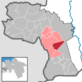
Location of Hesepe in the city of Nordhorn and in the Grafschaft Bentheim district
|
|
Hesepe is a former municipality in the Grafschaft Bentheim district in Lower Saxony . The district belongs politically to the town of Nordhorn .
geography
location
Hesepe is located in southwestern Lower Saxony, about four kilometers from the Dutch and 20 km from the North Rhine-Westphalian border. The nearest town is the Nordhorn district of Oorde (1 km north), the nearest towns are Nordhorn (4 km north-west) and Bad Bentheim (14 km south). Hesepe is accessed through the district road 27 Nordhorn - Engden (- Emsbüren ). The district borders on the Vechte in the southwest.
Neighboring places
Hesepe borders in the north on Klausheide , the farmers Feldflur and the district Stadtflur, in the west on the district Oorde and Brandlecht , in the southeast on Engden and in the easternmost tip on Lohne .
history
On July 1, 1929, the northern tip was incorporated into Nordhorn, on March 1, 1974, the whole of Hesepe was incorporated into the district town of Nordhorn.
Culture and sights
societies
In Hesepe there is the Heseper Sportverein 1978 e. V. with the departments football, dodgeball, gymnastics, boules and weight training. The first soccer team achieved a German record in 1999: they remained unbeaten in 98 championship games between October 1996 and October 1999. During this period, the team made it through from fifth to second district class.
Hesepe Chapel
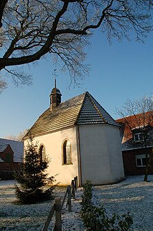
The Hesepe chapel dates from the 14th or 15th century. It does not belong to the parish, but to the formerly independent parish of Hesepe and thus the local farmers. The chapel is a listed building.
Economy and Infrastructure
traffic
Road traffic
Hesepe is located on Kreisstraße 27, which connects the federal highway 403 in Nordhorn with Engden. The Nordhorn / Bad Bentheim junction of the A 30 ( Bad Bentheim - Osnabrück - Bad Oeynhausen ) is around 10 km away, the Lingen junction of the A 31 ( Emden - Bottrop ) around 15 km.
Local public transport
In the afternoon the citizen bus route 33 of the Verkehrsgemeinschaft Grafschaft Bentheim (VGB) runs to Nordhorn and Brandlecht. The nearest passenger stations are the Nordhorn-Blanke stop approx. 3 km away, with a connection to the RB 56 line in the direction of Neuenhaus and Bad Bentheim, and the Bad Bentheim train station approx. 12 km away .
air traffic
The airport of the same name is located in Klausheide , about 10 km away . Motor planes with a maximum total weight of 10 t and gliders can take off and land here. The nearest international airport is Münster / Osnabrück Airport in Greven .
media
The regional daily newspaper in Hesepe is the Grafschafter Nachrichten .
literature
in order of appearance
- Heinrich Specht (edit.): The district of Grafschaft Bentheim (administrative district of Osnabrück). District description and regional planning plan together with statistical annex (= Die Landkreise in Niedersachsen , Series D, Vol. 9), Bremen-Horn 1953.
- Heinz Aldekamp, Werner Rohr: Nordhorn after 1945. Published by the Volkshochschule Grafschaft Bentheim. Nordhorn (Hellendoorn, Bad Bentheim) 1977, 1987, 1994 (5th edition).
- Ernst Kühle: Hesepe . In: Yearbook of the Heimatverein der Grafschaft Bentheim , ISSN 0437-1909 , year 1982, pp. 14-25.
- Bernd-Andreas Knoop: The big book of the county. Knoop, location 1984.
- Hubert Titz: Nordhorn - a journey through time. County of Bentheim, museum coordination and adult education center, Nordhorn 1998, ISBN 3-922303-30-7 .
- Margret Delißen (editor), Helmut Röh (ill.), Bärbel Görtzen: Nordhorn - border town without borders. Neomedia-Verlag, Reken 1999.
- Steffen Burkert (ed.): The county of Bentheim - history and present of a district . Publishing house Heimatverein Grafschaft Bentheim e. V., Bad Bentheim 2010, ISBN 3-922428-87-8 .
Web links
Individual evidence
- ↑ Geodata Center - Hesepe
- ^ Federal Statistical Office (ed.): Historical municipality directory for the Federal Republic of Germany. Name, border and key number changes in municipalities, counties and administrative districts from May 27, 1970 to December 31, 1982 . W. Kohlhammer GmbH, Stuttgart and Mainz 1983, ISBN 3-17-003263-1 , p. 254 .
- ↑ a b Website of the Heseper SV
- ↑ Dietrich Maschmeyer: The old peasant chapel in Hesepe, city of Nordhorn. A medieval religious building . In: Bentheimer Jahrbuch , ISSN 0723-8940 , vol. 1984, pp. 43-59.
- ↑ Line network of the VGB (PDF)
- ↑ https://www.be-mobil.de


