
Flood in Minden

Floods in Minden are hydrological events which, as a result of the particularly high runoff of the Weser, trigger a flooding in the area of the East Westphalian city. They occur almost annually. When the Weser reaches high water levels after prolonged rainfall or after the snow has melted, large areas of the Weser meadows in the area of Minden 's right bank of the Weser are flooded. But the city center on the high left bank of the Weser can also be affected. In 1946, during what is known as a flood of the century, the Weser flooded the city center right up to the cathedral . On the eastern bank, the station forecourt was under water. To protect against such a flood, a flood plan was drawn up in Minden in the 21st century.
Flood development
The Weser has a large catchment area through the two source rivers Fulda and Werra , which are in Hann. Munden meet and unite to the Weser. Here the area extends far into the Thuringian , Hessian and Bavarian low mountain ranges and covers around 19,300 km². Both source rivers of the Weser are regulated by hydraulic structures , locks partially enable navigability as a federal waterway , at least historically.
At the beginning of the 20th century, the expansion of the shipping canals between the Weser and the neighboring river systems was planned under Leo Sympher , which also included the source rivers Werra and Fulda (see , inter alia, Main-Werra Canal ). The Edertalsperre was built to regulate the Weser . In addition to flood protection, it also had the task of releasing water waves in bursts, which made it possible to increase the low water in the Upper Weser and thus make it navigable below in Fulda and Weser. The Edertalsperre is supplemented by the flow on the left side Diemel preferred Diemeltalsperre . By managing the two dams, it is possible to mitigate high water peaks and to make it navigable in summer when the water is low. This regulation also influences the flood behavior of the Weser from the point of origin of the Weser in Hann. Münden. It is located around 200 kilometers of the river above Minden, from here the flood runoff can be divided into several sections.
The first area extends from the point of origin of the Weser to Bad Karlshafen . Here the Weser is accompanied in the west and in the east by the Reinhardswald and the Bramwald , the river has little chance of spreading and flows through a narrow valley. The flood wave is characterized here by the superposition of the two flood waves of the source rivers Werra and Fulda.
At Bad Karlshafen, the Diemel flows into it as a left tributary from the west, which has a regulating barrage , the Diemel dam , in the upper reaches and can discharge water into the Weser in a targeted manner. In the event of a flood, the flood wave from the Diemel increases the flood discharge on the Weser.
The next section is wider, up to the tributary of the Emmer from the west. This flow is also regulated and can be controlled hydrologically.
After the Hamelin basin, the Weser valley narrows again, but is not as narrow as in the upper reaches. The strongly meandering river is accompanied by the Weserbergland in the north and the Lipper Bergland in the south . At Vlotho the river turns to the north, then at Bad Oeynhausen the Werre flows into the river from the west with a large catchment area from the Lipper Bergland.
In the Porta Westfalica , the river enters the North German Plain through the “Westphalian Gate” , Minden is the first town ten kilometers below on the former ford over the Weser.
Along a stretch of around 200 km, in addition to the two original rivers, three notable tributaries flow into the Weser, which can be used to define flood sections and which shape the flood in Minden. One in Hann. The flood wave built up in Münden reaches the city of Minden after around two to three days. This wave can be decisively influenced by the tributaries mentioned. In Minden, water levels above 4.50 m are perceived as flooding.
The Weser can be assigned to the so-called pluvio-nivalen (rain-snow-fed) discharge regime . This is typical for low mountain regions . The Weser is characterized by a summer minimum and two winter maxima. The first winter maximum is caused by precipitation at the beginning of winter in November / December.
In the low mountain ranges, precipitation is bound in the form of snow in winter. In the thaw period in February and March of the year this bound snow flows off. Due to the coincidence with spring precipitation, this second maximum can turn out to be particularly strong, as in 1946. An additional factor is that the subsurface is either frozen or saturated with water and therefore not absorbent.
As a result of the increased ingress of warm air in winter, the snow cover can already melt in the middle of winter. Often only a single, but wide discharge maximum is then formed.
Extreme floods occur less frequently in summer. These floods are triggered after days of rain on already saturated soils.
Sources
On the basis of the records of historians from earlier centuries, which describe the flood flow, the ice conditions and the damage caused, and the flood markings attached to buildings near the Weser, some of the highest water levels of the last 700 years or so have been reconstructed.
Affected areas in Minden
In 2010, the city of Minden published the “Plan of action for the city of Minden in the event of flooding” and profiles for the municipality of Minden. In the Weserglacis there is a flood stone on which the historical floods in Minden are recorded. There is another flood stone in the fishing town . Experience has shown that the following area is flooded when the water level is high.
| Water level at the Minden gauge |
Flooded areas / measures |
|---|---|
| 4.50 m | Weserradweg in the area of the Kleinbahnbrücke will be closed |
| 4.60 m | The Schlagde car park is closed |
| 4.80 m | Restrictions on shipping |
| 5.00 m | Internal administrative "specialist group on floods" meets |
| 5.10 m | The Kanzlers Weide car park will be closed |
| 5.60 m | Hausberger Straße and Weserpromenade will be closed |
| 6.10 m | Office for extraordinary measures of the city of Minden meets |
| 8.10 m | Flood of the century February 10, 1946 - flooding of the station forecourt, city center to the cathedral |
Flood events

From the above-mentioned sources and the chronicle of the city of Minden, flood events are compiled here, insofar as they affect the city of Minden.
- July 1342
- The event, also known as the Magdalenen flood, not only caused the highest historically recorded water level in the Upper Weser, but also devastated large parts of Central Europe.
- February 10, 1375
- Weser flood, the water was in Minden Cathedral.
- 1513
- In 1513 a flood caused by persistent downpours tore the wooden bridge over the Weser from five stone pillars.
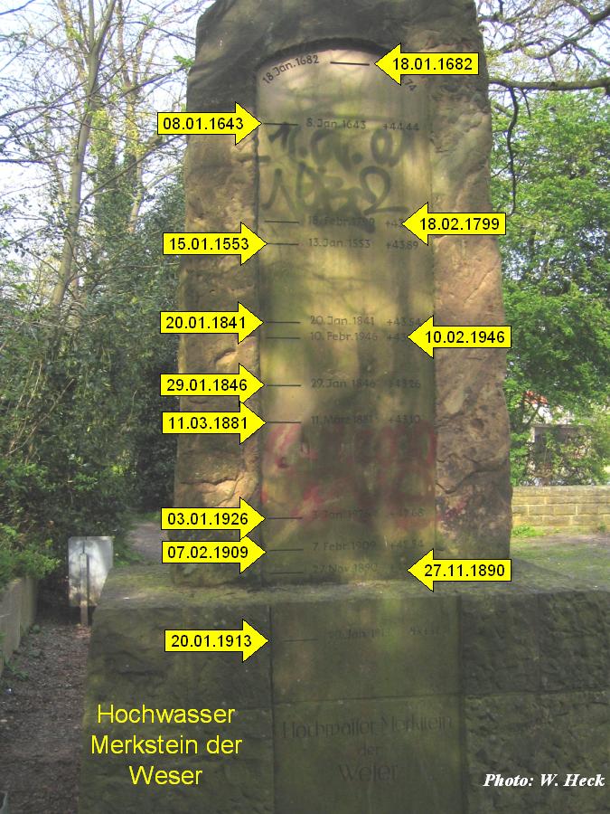
- January 13, 1553
- The flood flooded the Mindener Weser bridge and stood on the market; then an epidemic broke out.
- January 7th and 8th, 1643
- Weser flood; the water was so high that ships could be entered directly from the bridge.
- February 16, 1658
- Weser flood; the Weser bridge was damaged.
- 1664
- Weser flood.
- January 7, 1682
- Second highest known flood of the Weser; the Minden market square could be used by boats.
- March 6, 1744
- Weser flood
- February 24, 1799
- Weser flood, only three inches lower than 1553; four arches of the colorful bridge collapsed.
- January 20, 1841
- Weser flood
- May 16 and 17, 1943
- During the night the Edersee dam was destroyed by a British air raid ( Operation Chastise ). A hole 70 meters wide and 22 meters deep was created in the wall, from which around 160 million cubic meters of water flowed. A six to eight meter high tidal wave flowed through the valleys of the Eder, the lower Fulda and the Weser and caused considerable flooding and property damage as far as Minden.
- October 26, 1944

- A bomb attack on the canal systems on Friedrich-Wilhelm-Strasse resulted in a direct hit on the canal embankment. As a result, large masses of water suddenly escaped and flowed into the south upstream land below the embankment. The dam of the Mittelland Canal was destroyed at 50 meters. The Mittelland Canal ran completely empty between the lock gates in Hahlen in the west and Berenbusch in the east. The masses of water carried five barges with it onto the lower ground and also spilled onto the grounds of the Busch brothers' box factory . The bomb shelter had been hit directly before. In this mass of water, which also penetrated the air raid shelter, 73 people died, including ten Polish women who had to do forced labor in Germany during World War II.
- February 10, 1946
- The flood of the century , known as the February flood in 1946, led to a water level of 8.20 m in Porta and a water level of 7.90 m in Minden. In Minden the Weser stood in the lower old town of Minden, which meant that the fishing town was under water and the Häszuer on the bridgehead in the basement, which was close to the river, were flooded.
- The abundant rainfall at the beginning of February 1946 quickly affected runoff, as the soils were saturated with water and could no longer absorb any significant additional water. The precipitation went straight into the drain without being buffered by the ground. Therefore this flood was classified as rain flood and not snowmelt flood. In the upper reaches of the Weser, especially in the Weser Uplands and in the Lipper Uplands, there was sometimes up to 300 mm of precipitation.
- July 1, 1956
- July flood 1956 : After a very wet spring and days of cloudbursts in the mountains of Lower Saxony, Hesse, Thuringia and East Westphalia, there was a severe flood of the Weser with large floods as far as the Bremen area.
- July 19, 1965
- Heinrichsflut ; Severe storms in northern Hesse, eastern Westphalia and southern Lower Saxony led to a catastrophic flood, which hit Bad Karlshafen particularly hard.
- March 15, 1981
- As a result of heavy snowmelt and prolonged rainfall, flooding occurred in Minden. During the Weser breakthrough in 1981 , the summer dike broke in Bremen . Water flowing through partially completely destroyed several allotment garden areas. The flood was slow to recede, and medium water flow did not return until April.
- January 5, 2003
- The high water mark of 6.40 meters reported the automatic announcement of the level porta on January 5, 2003. The Mindener Glacis , parts of the pedestrian bridge, parking areas and also the Mindener Schiffmühle were "in the middle of the Weser". For the first time, the ship mill had not been towed into the winter camp due to permanent flooding, but it survived the high Weser floods unscathed.
- March 2010

- With a water level of 5.64 meters, the city of Minden was spared major problems. Schlagde and Weserradweg were under water, parking on Kanzler's pasture had to be banned for one day and building materials at the “Bunte Brücke” construction site suffered from the flood.
- January 7, 2018
- The flood in Minden reached a high of 5.60 m at the Porta gauge. The Schlagde was flooded and the Kanzlers Weide large car park was closed from Wednesday until the beginning of the following week. The flood bridge Bunte Brücke on the eastern bank of the Weser was completely undermined. Hausberger Strasse, however, was not flooded.
literature
- Knut Kaiser, Bruno Merz, Oliver Bens, Reinhard F. Hüttl (eds.): Historical perspectives on water balance and water use in Central Europe . Waxmann, 2012, ISBN 978-3-8309-7657-8 , pp. 122 ( books.google.de [accessed January 30, 2018]).
Web links
- 70 years after the flood in OWL: There is still a risk of extreme floods. Accessed January 30, 2018 .
- The flood in 1946 was not a deluge. Accessed January 30, 2018 .
- Floods on the Weser - a phenomenon of the past? Accessed January 30, 2018 .
- Flood hazard and planning of measures Minden. Accessed January 30, 2018 .
- Flood Merkstein of the Weser. Accessed January 30, 2018 .
Individual evidence
- ↑ Mindener Tageblatt: "Wasserlandschaft", p. 4, print edition from January 6, 2018.
- ↑ WSA Hann. Münden: Management of the dams , accessed on January 26, 2017
- ↑ WSA Hann. Münden , accessed on January 26, 2017
- ↑ Weserfreunde Minden: History and flood behavior , accessed on March 27, 2017
- ↑ Flood risk management planning in NRW. Flood hazard and planning of measures Minden. River basins in NRW. Retrieved January 14, 2017.
- ↑ a b c d e f g h i j k l m n Chronicle of the city of Minden
- ^ Amtage: Stadtgeschichte Minden: 1945 air raid on Minden , accessed on October 14, 2016
- ↑ Mindener Tageblatt: Wasserlandschaft , p. 4, print edition from January 6, 2018
- ↑ Undine information platform: Flood events in the Weser region: The February flood in 1946 , accessed on January 14, 2018
- ↑ Undine information platform: Flood events in the Weser region: The March flood in 1981 , accessed on January 14, 2018
- ↑ Schiffmühle Hochwasser , accessed January 14, 2018
- ↑ [1] , accessed on January 14, 2018
- ↑ Mindener Tageblatt: Schlagde free again after flooding Edition of January 12, 2018, accessed on January 14, 2018