Minden Glacis
The Mindener Glacis [ɡlaˈsiː] is a listed city park that surrounds the inner city of the East Westphalian city of Minden in North Rhine-Westphalia .
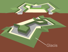
In front of the site of the former Minden fortress is the Mindener Glacis , the former free field of fire, and still traces the former course of the fortifications in the city map . When the fortress was razed after the establishment of the German Empire in the 1870s and the areas that were freed up came into municipal ownership, extensive parks with high recreational and recreational value were created on the glacis. The military name Glacis was retained for the park. Today the city park forms an almost complete ring of 4.6 km in length around the Minden city center . The old fortress wall only still exists in the Fischerstadt an der Weser district . Here it protects the district from flooding and is a listed building.
history
In the Middle Ages it was necessary to secure the important cities with ramparts and to control access at city gates . Minden had been surrounded by a wall since the 13th century and was expanded into a fortress from the early 16th century. After the Thirty Years War , Minden fell to Brandenburg-Prussia and was expanded into one of five country fortresses in the Kingdom of Prussia from the 18th century . With the reconstruction and expansion of the fortress, the city became more and more constricted.
At the time of the Franco-Prussian War , military technology had developed so far that fortifications were no longer sufficient to protect the cities and could be abandoned. On May 30, 1873, the German Reichstag passed the law to abolish the fortresses of Minden, Stettin , Erfurt , Wittenberg , Kosel , Graudenz , Kolberg and Stralsund . Then the Royal Domain Treasury, represented by the government in Minden with the city's magistrate, negotiated the future of the fortress. An agreement was reached in the autumn of 1878. The city bought the fortress grounds for 118,700 gold marks , payable in five installments.
The rayon regulations had already been repealed on October 1, 1873. These said that a free field of fire in front of the fortress walls could not be built on. With the abolition of the Minden fortress, the land near the military installations could be built on. The city gates were opened and laid down. Gaps were torn in the city wall and the city was opened to the surrounding area. In the area of the glacis, 10 hectares were to be retained as a "landscape facility". The city of Minden, however, was not responsible for the park-like design and greening, but the city of Minden's beautification association . The association signed a contract with the city of Minden on December 20, 1878, which obliged him to design the glacis.
The plots in the immediate vicinity of the now green Glacis offered particularly wealthy citizens the opportunity to settle in the middle of the countryside right outside the city gates. As a result, numerous spacious villas in the Wilhelminian style and Art Nouveau were built on the side of the Glacis facing away from the city , which still characterize this area today. Only on the banks of the Weser, the Weserglacis, did a different development take place: the impending flood and the banks of the Weser did not make it possible to designate safe building sites. This did not lead to a development with representative buildings until later, after the former trenches were filled in. The former government and the former district building were built here.
On February 9, 2017, the glacis were entered in the list of monuments of the city of Minden . In May 2017 they were selected by the LWL Monument Preservation, Landscape and Building Culture in Westphalia as Monument of the Month in Westphalia-Lippe .
From 2018 the city of Minden will develop a maintenance and development concept Glacis.
Location and sections of the glacis
The city of Minden lies on two river terraces on the left bank of the Weser; from the Weser it extends over the stepped terrain in the urban area up to the upper old town. Therefore, the surrounding glacis in the area of the Weser has the lowest altitude at 41 meters normal height and rises to the west up to 59 meters above sea level. Today the glacis is divided into six sections, which are named according to the sections of the Mindener fortress: Along the Weser lies the Weserglacis . The fishing glacis north of it surrounds part of the so-called fishing town and leads west to the hillside. This is where the somewhat neglected Mary or health spring is located. The Marienglacis , named after the St. Marienkirche , connects to the west. The Minden Old Cemetery is located in the southwestern Königsglacis . The major military expansion with the Simeonsglacis follows in the south . With the Glacis on Wittekindallee , the ring closes on Weserglacis.
Todays use

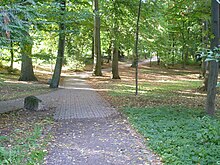
As early as the end of the 19th century, the beautification association had a green belt with a promenade and paths laid out on what was previously an open field of fire . Here you will mainly find ash , oak , red beech , sycamore maple and horse chestnut . Ornamental beds can be found in the Weser and Königsglacis.
In the Marienglacis area there is the listed imperial villa with a pond and the Herder high school . In the area of the Königsglacis there is the Wilhelmshöhe, a 10 meter high hill that is used as a toboggan hill in winter. This is where the old open-air stage was located, which was played on in the 1950s. Today the area is overgrown. The wooden bridge over the Bastau connects this part of the glacis with the Simeonsglacis south of the city. In 2013 the renovation of the bridge was negotiated. The barracks from the Prussian era are located on Simeonsplatz. Today they are developed as a Prussian Museum , parts of the barracks are built on with city villas. To the east of Portastraße is the old clinic area of the city of Minden, which is now facing new forms of use.
A promenade was laid out on the Weser, providing a view of the Porta Westfalica with the Kaiser Wilhelm monument and the Weser meadows. Numerous hiking trails have been laid out through the Weserglacis. The Sigwardsweg pilgrimage route leads through the Weserglacis, which, like the Weser cycle route from Hannoversch Münden to Bremen, has its course here.
In the glacis there are the remains of a fitness trail that used to consist of 19 stations . A jogging and walking route with kilometer boards over 4.6 km has been signposted in the Glacis since 2011. The Green Space Office of the City of Minden has been sponsoring individual trees and entire sections since 2013.
The Mindener Glacis has an important function in urban ecology and absorbs particulate matter and noise . The wind in the local area is also influenced by this.
Botanical Garden
As part of the Königsglacis, a botanical garden has been created on the west side of the park ring on an area of 5.5 hectares . This area was originally the old cemetery of Minden, the first burial site in the city outside the fortress ring. A number of burial sites and old trees have been preserved. The redesign of the listed site took place after the cemetery was abandoned as the main burial site for the city of Minden in 1951. Urn burials are still carried out in the cemetery today.
Weser promenade
Towards the Weser, the promenade laid out there was extended to the south in the 20th century via the old site of the former British barracks, including the old pioneer training area and thus upgrading the entire Weser glacis. Numerous water sports clubs and leisure facilities are located here today. The Weser promenade was also extended to the north outside the glacis to the north bridge. To get a connection from the Glacis to the Chancellor's Weide (with festival and parking lot) on the right bank of the Weser , the Glacis Bridge was built over the river in the 1990s , a slender reinforced concrete construction for pedestrians. For the 1200th anniversary of the city of Minden, a replica, functional ship mill was anchored on the banks of the Weser . In the southern part of the Weser promenade there is the Mindener Sommerbad, the Weser Stadium and a mini golf course. Buildings for boat clubs and an amphitheater with a skater track are located directly on the Weser . The Minden Fahrgastschifffahrt has a dock at the Weser Glacis. To the north of the Fischerstadt area, the promenade merges into the Schlagde , today used as a parking lot in front of the preserved, restored parts of the fortress wall in front of the Fischerstadt district of Minden.
Swan pond
The swan pond was created in the area of the southern Weserglacis. It was created in the area of the old river bed of the Bastau, which was moved to a new confluence with the Weser to the south. The swan pond is fed by the Bastau, which was dammed to create a lake. For this purpose, the Bastau was equipped with an attack weir in front of the confluence with the Weser. The swan pond has a duck house in the middle. The western shore of the lake is supported with parts of the old fortress wall. Two pedestrian bridges with wrought iron railings were built over the Bastau in this section. In 1985 the swan pond was desludged and cleaned after a long time. The weir in the Bastau was opened in May 2015 and replaced by a fishable sole track.
Monuments in the glacis

Numerous monuments have been erected in the glacis.
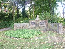
- The Schwichow monument is located in the Simeonscarre. It is intended to commemorate the popular commander of the Minden Fortress, Ernst Michael von Schwichow , and was designed by the Prussian master builder Karl Friedrich Schinkel .
- In the Weserglacis there is a memorial for the infantry regiment “Prince Friedrich of the Netherlands” (2nd Westphalian) No. 15 , which was erected with soldiers from the region.
- In Marienglacis there is a memorial to gymnastics father Jahn , after whom a sports field on the right bank of the Weser was named.
public relation
The Glacisschützer interest group was founded in 2010 . In 2013, on the Day of the Open Monument , she launched a Glacis Day , which was opened by Minden's Mayor Michael Buhre . In addition to the increased attention to the recreational area in the city, the commitment of the citizens for their park is to be strengthened.
Individual evidence
- ↑ a b c d Monika M. Schulte: Promenading in the countryside and living in villas. In 1878 the fortress becomes the property of the city of Minden via an article by the head of the municipal archive, accessed on August 28, 2013
- ^ Glacis facilities in Minden - 720. In: Geodatenportal Minden. City of Minden, Department 5, Team GEOService, accessed on May 3, 2017 .
- ↑ Uwe Siekmann: Monument of the month: The Mindener Glacis. (No longer available online.) LWL monument preservation, landscape and building culture in Westphalia , formerly in the original ; accessed on June 2, 2017 . ( Page no longer available , search in web archives ) Info: The link was automatically marked as defective. Please check the link according to the instructions and then remove this notice.
- ↑ Mindener Tageblatt: Glacis Concept will be presented on April 2, retrieved on April 1, 2019
- ↑ Heinz voter: Glacis Rundwanderweg Minden , In: Mindener Tageblatt (Ed.): 75 excursion destinations in Minden-Lübbecker Land , Verlag JCC Bruns, 8th edition, Minden 2010.
- ↑ Mindener Tageblatt: MINDEN AND THE SURROUNDING AREA ON OLD POSTCARDS: Secret of Lorraine Artilleryman Revealed Edition of August 15, 2008, accessed on January 6, 2014
- ↑ a b Prussian Tour: the Glacis ( Memento of the original from December 13, 2013 in the Internet Archive ) Info: The archive link was inserted automatically and has not yet been checked. Please check the original and archive link according to the instructions and then remove this notice. , accessed August 27, 2013.
- ↑ a b Das Glacis: Once around the city of Minden ( Memento from October 15, 2013 in the Internet Archive )
- ↑ Mindener Tageblatt: Mindener Greens want to do without the Bastau Bridge Edition of November 27, 2013, accessed on December 10, 2013
- ↑ Homepage of the city of Minden: 4.6 kilometers through the Glacis: Signs show joggers and walkers the way, accessed on September 11, 2013
- ↑ a b Mindener Tageblatt: Tag des Glacies: The green monument of the city of Minden Edition of September 10, 2013, accessed on September 10, 2013
- ^ Homepage of the city of Minden , accessed on September 4, 2013.
- ↑ Amtage: Alter Friedhof Minden ( Memento of the original from January 20, 2016 in the Internet Archive ) Info: The archive link was inserted automatically and has not yet been checked. Please check the original and archive link according to the instructions and then remove this notice. , accessed February 16, 2016.
- ↑ Mindener Tageblatt: Schiffmühle Minden is 15 years old Edition of November 29, 2012, accessed on September 30, 2013
- ↑ Mindener Rundschau: Minden: Old Glacis Forest Park should be in the focus of the public again , accessed on September 11, 2013.
Web links
- Glacis protector Minden
- The Glacis systems (mt-online.de)
- Master plan of the city of Minden
- Map of Minden
- Landschaftsverband Westfalen-Lippe: Mindener Glacis in LWL geodata culture
- Development concept Glacis of the city of Minden.Process start in June 2018
Coordinates: 52 ° 17 '6.1 " N , 8 ° 55' 8.1" E


