Holderberg (Moers)
|
Holderberg
City of Moers
Coordinates: 51 ° 24 ′ 41 ″ N , 6 ° 36 ′ 28 ″ E
|
||
|---|---|---|
| Residents : | 1218 (December 31, 2015) | |
| Postal code : | 47447 | |
| Area code : | 02841 | |
|
Location of Holderberg in North Rhine-Westphalia |
||
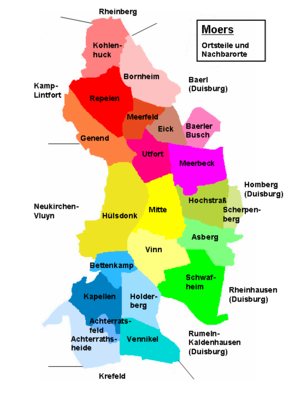
Holderberg is one of six districts of Kapellen , a district of the North Rhine-Westphalian city of Moers in the Wesel district . The place, which is located in the southern area of the city of Moers, has 1,218 inhabitants.
location
With the exception of the east, in which the Rumeln-Kaldenhausen district of Duisburg is located, other Moers residential areas surround Holderberg. Specifically, these are Vennikel in the south, Kapellen-Mitte in the west, Bettenkamp in the north-west and Vinn in the north . In the northeast there is also a small border area to Schwafheim . In terms of traffic, Holderberg is in the area of the BAB 40 and BAB 57 motorways. The BAB 40, which runs from west to east, runs in the north above the area of the residential area, but the Moers motorway junction is nearby. The BAB 57 motorway runs from north to south and forms the western border of the local area with Bettenkamp and Kapellen-Mitte.
The current settlement area of Holderberg is mainly in the northern area of the residential area. The southern part belongs to the forest area of the Lauersforter Wald, which extends to the residential area of the Vennikel residential area and which is one of the few larger forest areas in the northern part of the left Lower Rhine.
history
There are almost no traces of at least a temporary stay of people in the Holderberg area until modern times. So far, a probable settlement site from the Stone Age has only been found in the eastern area before the border with Schwafheim at a point with scratches, blades and shards of flint.
Although the Holderberg area may originally have belonged to the sphere of influence of the Königshof Friemersdorf, the records of the Werden monastery from the Middle Ages do not mention any court in this area. However, the entire area from Holderberg was only sparsely populated until the end of the 19th century. Apart from the aristocratic seat of Schloss Lauersberg, which is located in the southern area of the residential area, most of the farms in the Middle Ages were located in an area called Am Berg . While various documents are available for the noble seat of Lauersfort in the late Middle Ages, there is almost no written evidence for the wider area of Holderberg and Am Berg. As far as there are indications, these concern chapels, which obviously also included the current area of Holderberg.
In a study of 1836 for the administrative district of Düsseldorf there were only four residential buildings and thus only four farms in addition to Lauersberg Castle in the Holderberg area. At that time, the hamlet of Holderberg belonged to the more populated mountain farming community. The latter consisted of 29 residential buildings with 278 residents. In the collective municipality of Kapellen, the Berg farming community and Lauersfort Castle were combined into one of the four separate departments. In 1834, in addition to the twenty residents in the palace area, a total of 312 other people lived in the Berg with Holderberg area. With the exception of two Catholic residents of the castle, all the others who had belonged to the Kapellen parish since the middle of the 16th century were Protestants. The justice of the peace in Moers was legally responsible. The affiliation with chapels did not change in the course of the 19th century. In a publication from 1850 in the official gazette for the Düsseldorf administrative region, Holderberg was still cited as part of chapels. In the meantime only Holderberg was used as a name in the Official Journal. In contrast, an address book from 1901 listed both Berg and Holderberg as part of the municipality in Kapellen, with Holderberg also being marked as a connection for the railroad.
Attractions
In the list of architectural monuments in Moers , two architectural monuments are listed for Holderberg :
- Lauersfort Castle (Lauersforter Straße 35), which dates back to the 14th century in its oldest parts
- the Agnetenhof (Holderberger Straße 169)
Web links
Individual evidence
- ↑ Population figures according to the city of Moers for chapels, as of December 31, 2015
- ↑ Wensky, Margret, in: Moers. The history of the city from the early days to the present . 2000, Böhlau Verlag, Cologne, Volume 1, p. 409. ISBN 3-412-04600-0
- ↑ Erpf, Christa; Plow, Günther. In: selection directory. District of Düsseldorf. Chapels . 1971, p. [54] 52. Online version
- ↑ Vierbahn, Johann Georg von. In: Statistics and topography of the Düsseldorf administrative district. Second part . 1836, p. 106.
- ^ Official Journal for the Düsseldorf administrative region. In: Supplement to the Official Journal . 1850, p. [819] XX. Online version
- ↑ Berenberg. In: Grosses Landes-Adressebuch . 1901, Hannover, p. [1173] 1099. Online version

