Eick (Moers)
|
Eick
City of Moers
Coordinates: 51 ° 29 ′ 0 ″ N , 6 ° 38 ′ 0 ″ E
|
||
|---|---|---|
| Height : | 23 (22-25) m above sea level NN | |
| Area : | 1.76 km² | |
| Residents : | 5093 (December 31, 2014) | |
| Population density : | 2,894 inhabitants / km² | |
| Incorporation : | 1st January 1975 | |
| Postal code : | 47445 | |
| Area code : | 02841 | |
|
Location of Eick in North Rhine-Westphalia |
||
|
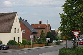
Entrance to Eick-West, in the background the steeple of the Church of St. Ida
|
||
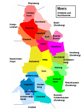
Eick is a district (officially a residential area ) in the Rheinkamp district in the northeast of Moers in the Wesel district in North Rhine-Westphalia .
location
The district borders in the north on Bornheim , in the east on the Duisburg district of Baerl and Baerler Busch , in the south on Meerbeck and Utfort , in the west on Meerfeld . The national road 137 crosses Eick in north-south direction and cuts in Eick Eick-West and East-Eick.
history
The place name is derived from the name of a local noble family, the Lords of Eyck , who have been traceable since the first half of the 13th century. This name in turn suggests large oak forests in the area.
From the Iron Age, there are extensive traces of temporary human settlement in the Eick area. For this period of time , an extensive burial ground was found in the north-eastern area from Utfort to the area of Eick between Rheinberger Straße and in front of the railway embankment. This burial ground has so far comprised nine individual graves and dates from the early to middle Iron Age. In the graves, which are urn graves, burn bones and remains of the urn vessels including the associated cover bowls and broken pieces of pots and bowls were found.
A little to the northwest of this burial ground and further in the area of Rathausallee and Oderstraße, settlement remains, a single Roman grave, graves with a tuff stone box and three single-handle jugs as well as pre-Franconian settlement remains with ceramic shards, remains of amphorae, iron parts, slag and broken glass from Roman times were excavated. The coins found indicate a period from the 1st to the 3rd century AD.
Even more extensive remains were excavated in the area of the Oderstrasse, dating from the Merovingian era in the 5th to 9th centuries. Remains of a first grave were found in a field as early as 1932. During intensive excavations from 1957 to 1959, another 163 graves were uncovered. These concerned seven graves in circular trenches, 52 graves with wooden cladding as well as eight graves with tree coffins and 23 plank graves. Although the graves in the district trenches in particular, which are likely to have come from high-ranking personalities, had been looted, many grave attachments were still found. These included various ceramic vessels, weapons such as lances, swords, axes and knives as well as jewelry made of amber and glass as well as fibulas . This large number of graves is a clear indication of post-Roman settlement by the Franks, whose exact settlement area could not be clearly determined, although it must have been near the grave complex.
From the knight's seat or court of the above mentioned Knights von Eick , also de Ech, Eyke, Ek or Ei (c) k , which were traceable since 1226, a localization as with the settlement from the time of the Merovingians is also not possible so far. Presumably it was oriented towards Repelen . In the camp register of the St. Barbara monastery in Rheinberg, the Teutonic brother "Georg von Eick" is listed as a member of the family of the Lords of Eyck in 1321. In another publication, Georg von Eick is named as the founder of the chapel of the branch of the Teutonic Order in Rheinberg for the year 1321 .
The area of Eick was sparsely populated until the beginning of coal mining in the area of Moers. The settlement island was located in a large forest area that stretched northeast of Moers. Only a few farms can be identified that have belonged to the parish of Repelen since the Middle Ages. In a study from 1836, in 1834 the Eick farmers in the municipality of Repelen consisted of only six, some of them larger, farms with 95 inhabitants, all of whom were Protestants. The latter, along with the Protestants in Bornheim and Utfort, were now part of the parish of Moers. The few Catholics who lived in this area belonged to the Catholic Church until the construction of the Church of St. Barbara in Eick-West in the 20th century. Community in Rheinberg. Nothing had changed in the low population of Eick until 1901. The number of farms had risen to only nine, but a few first craftsmen had now also settled.
Individual evidence
- ↑ The earliest mention of the Rheinkamp place names and their interpretation. Retrieved August 15, 2015 .
- ↑ Wensky, Margret, in: Moers. The history of the city from the early days to the present . 2000, Böhlau Verlag, Cologne, Volume 1, p. 413. ISBN 3-412-04600-0
- ↑ Wensky, Margret, in: Moers. The history of the city from the early days to the present . 2000, Böhlau Verlag, Cologne, Volume 1, p. 431. ISBN 3-412-04600-0
- ↑ Wensky, Margret, in: Moers. The history of the city from the early days to the present . 2000, Böhlau Verlag, Cologne, Volume 1, pp. 63-68. ISBN 3-412-04600-0
- ↑ Wensky, Margret, in: Moers. The history of the city from the early days to the present . 2000, Böhlau Verlag, Cologne, Volume 1, p. 69. ISBN 3-412-04600-0
- ↑ Boisserée. In: Annals of the Historical Association for the Lower Rhine . 1883, issue 39, Cologne, p. [54] 44. Online version
- ^ In: Journal: Niederrheinischer Geschichtsfreund. No. 11 . 1883, Kerpen, p. [90] 86. Online version
- ↑ Vierbahn, Johann Georg von. In: Statistics and topography of the Düsseldorf administrative district. Mayor's Office Repelen . 1836, Part Two, p. 107.
- ↑ Berenberg. In: Grosses Landes-Adressebuch. 1901, Hannover, p. [1191] 1117. Online version


