
Hochstraß (Moers)
|
Hochstraß
City of Moers
Coordinates: 51 ° 27 ′ 0 ″ N , 6 ° 39 ′ 28 ″ E
|
||
|---|---|---|
| Height : | 27.5 m above sea level NN | |
| Area : | 2.45 km² | |
| Residents : | 13,999 (Dec. 31, 2015) | |
| Population density : | 5.714 inhabitants / km² | |
| Incorporation : | April 1, 1906 | |
| Postal code : | 47443 | |
| Area code : | 02841 | |
Location of Hochstraß in North Rhine-Westphalia |
||

Hochstraß is a district (officially residential area ) of the Moers district in the east of Moers in the Wesel district in North Rhine-Westphalia .

location
The district borders in the north on Meerbeck , in the east on the district Uettelsheim of the Duisburg district Baerl and on Scherpenberg , in the south on Asberg and in the west on Moers-Mitte .
history
Although Hochstraß is located on the historic Roman Road, no finds from Roman times have been identified so far. The same applies, with one exception, to verifiable traces of the at least temporary residence of people on the Lower Rhine before the Roman era. The only place of discovery, to the right of the Westerbruch Graben, with various shards of burnt vessels, remains of millstones and burnt smelter clay indicate a settlement from the early and middle Iron Age .
There is no place name Hochstraß in old documents or on older maps . The rural settlement was in the district emerged Birck. The place developed in the area of the flood-protected and for the time well fortified Roman road (former federal road 57 and current state road 137), which led along the Rhine via Cologne , Neuss , Asberg to Xanten . This fortified and " high- lying Strasbourg e", which resulted in many places on uneven and boggy ground, gave the community Hochstraß the name. Older location details therefore refer to this street profile. For example, in an old newspaper from 1825, the address “between Hochstrasse and Moers” is given. In another newspaper from 1841, the location is "between Hochstraße and Moers". At the end of the 19th century, "Hoch Straß" was still being used more frequently for areas of the Römerstraße between Rheinberg and Moers and did not only refer to the current local area of Hochstraß.
Towards the end of the 18th century, Hochstraß was formed together with Scherpenberg and the district of Westerbruch, since in a list of rural settlements from 1787 for the Moers community, in addition to Asberg, Hülsdonk, Schwafheim and Vinn, Hochstraß was also listed.
The rural community of the farmers Hochstraß, Westerbruch and Scherpenberg was merged in 1800 with the rural communities Asberg, Fünderich, Hülsdonk, Vinn and Schwafheim with the city of Moers by the French to form Mairie Meurs (Moers) in the Département de la Roer .
After the end of French rule, Hochstraß remained in this administrative community in the Moers mayor's office. In a study of 1836 for the Düsseldorf administrative region, the hamlet Hochstraß was cited, which was administered by a joint mayor in 1834 with the city of Moers and five rural communities. At that time, the two farmers Hochstraß and Fünderich were combined into one administrative unit. The local areas comprised 37 residential buildings with 264 residents for Hochstrasse and nine buildings with 58 residents in Fünderich. Except for two Catholics, all residents were Protestant and belonged to the Protestant community of Moers. Juridically, the peace court in Moers was responsible.
After the middle of the 19th century, Hochstraß became an independent municipality again. In a listing from 1901, the community Hochstraß consisted of the village of Hochstraß from the peasant communities Moerserheide, Scherpenberg and Westerbruch. The number of residents in this parish was 1,843 people.
On April 1, 1906, Hochstraß was incorporated into Moers together with Asberg, Hülsdonk, Schwafheim and Vinn.
Coal mining
In the middle of the 19th century, Franz Haniel founded a company for the construction of coal mines on the left Lower Rhine. In 1857 the sinking of shaft 1 in Homberg began. After the death of Franz Haniel in 1868, the successors from the Haniel family founded the Rhine Prussia mining law union . In 1875 the coal mining company Rheinpreußen started the coal mining at shaft 1. With the further expansion of the coal mining, the sinking of shaft 4 of the mining company Rheinpreußen east of the Römerstrasse in Hochstraß was carried out from 1900 to 1904. A double headframe with the associated facilities and colliery buildings and a coking plant were built on the site. Coal production through shaft 4 began in 1904. While the coking plant ceased operations in 1958, coal production through shaft 4 was not stopped until the end of 1964. The shaft was used as a weather and water holding shaft until 1990 . In 1990 the shaft was backfilled, the headframe and some colliery buildings with machinery were renovated to become an industrial monument . The headframe of shaft 4 with the still existing colliery buildings in the Ruhr area is currently part of the route of industrial culture with periodic events.
Attractions
In the list of architectural monuments in Moers , three architectural monuments are listed for Hochstraß :
- the Catholic Church of St. Marien (Königsberger Straße), built between 1928–1929
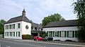
- the Vredenhof (Römerstraße 586), a former moated castle from the 17th century, which has been preserved as a historical farm in the classic architectural style of the lower Lower Rhine
- Shaft IV , Zeche Rheinpreußen (Zechenstraße): Headframe with machine building is a testimony to the beginnings of mining in Moers city area. There is the oldest preserved headframe with double struts. The carrier building is the most historic of all buildings.

St. Mary
Vredenhof

Headframe of the "Rheinpreußen" colliery, shaft 4


Web links
- nbn-resolving.de Digitized edition of the "History of the County of Moers" by Carl Hirschberg
- Grafschafter Museum
- Data and facts in Moers
- Mairien in the department de la Roer
Individual evidence
- ^ Moers - districts and residential areas. Retrieved August 15, 2015 .
- ↑ Wensky, Margret, in: Moers. The history of the city from the early days to the present . 2000, Böhlau Verlag, Cologne, Volume 1, p. 421. ISBN 3-412-04600-0
- ↑ Düsseldorfer Zeitung. In: Issue No. 178 of July 2nd, 1825 . 1825, p. [718] -. Online edition
- ↑ Düsseldorfer Kreisblatt. In: Issue No. 4 from 4.1.1841 . 1841, p. [15] -. Online edition
- ^ In: Annals of the Historical Association for the Lower Rhine . 1883, issue 39, p. [16] 6. Online version
- ↑ Wensky, Margret, in: Moers. The history of the city from the early days to the present . 2000, Böhlau Verlag, Cologne, Volume 2, p. 108. ISBN 3-412-04600-0
- ↑ Mairie Meurs. Retrieved June 3, 2016 .
- ↑ Vierbahn, Johann Georg von. In: Statistics and topography of the Düsseldorf administrative district. Second part . 1836, p. 106.
- ↑ Berenberg. In: Grosses Landes-Adressebuch . 1901, Hannover, p. [1188] 1114. Online version
- ↑ Scherpenberg story. (No longer available online.) Archived from the original on January 27, 2016 ; accessed on August 16, 2015 . Info: The archive link was inserted automatically and has not yet been checked. Please check the original and archive link according to the instructions and then remove this notice.
Remarks
- ↑ The course of the historic Römerstraße is called "Hohe Straße" in many areas of West Germany, as it was raised by the Romans like a dam. The names "Steinstraße", "Alte Straße" or "Heerstraße" are also used. Proof: In: Annals of the Historical Association for the Lower Rhine . 1883, issue 39, p. [87] 77. Online version
- ↑ In 1812 Mairie Meurs was also responsible for Hochstraß in accordance with the list given. In 1834, Hochstraß continued to belong to the municipality of Moers. When Hochstraß left the municipality of Moers again and whether this only happened when the district of Moers was formed in 1857 or later, needs to be clarified.
Moers : Moers-Center | Asberg | Hochstraß | Hülsdonk | Scherpenberg | Schwafheim | Vinn
Chapels : Chapel Center | Achterathsfeld | Achterathsheide | Bettenkamp | Holderberg | Vennicle
Rheinkamp : Rheinkamp-Mitte (Meerfeld) | Baerler Busch | Bornheim | Eick | Genend | Coal huck | Meerbeck | Repelen | Utfort