Achterathsheide
|
Achterathsheide
City of Moers
Coordinates: 51 ° 24 ′ 34 ″ N , 6 ° 34 ′ 4 ″ E
|
||
|---|---|---|
| Height : | 31 m above sea level NN | |
| Residents : | 304 (December 31, 2015) | |
| Postal code : | 47447 | |
| Area code : | 02841 | |
|
Location of Achterathsheide in North Rhine-Westphalia |
||
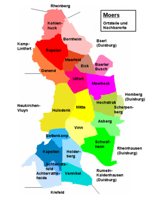
Achterathsheide is one of six districts of Kapellen , a district of the North Rhine-Westphalian city of Moers in the Wesel district . The place, which is located in the southwest of the city of Moers, has 304 inhabitants.
location
Achterathsheide is south of Kapellen-Mitte and in the northeast and east of the local area are the residential areas Achterathsfeld and Vennikel . While the local area borders on Neukirchen-Vluyn in the west, Krefeld is in the southeast .
history
So far there is no evidence of a settlement of the Achterathsheide before the Middle Ages. Broken bricks and ceramic shards were found in 1979 at one point only south-east of the local area near the Hörnemannshof, but these were not examined in detail and possibly date from Roman times.
In keeping with the name “Heide”, farms could only be built in a few places in the local area due to the quality of the soil and the area is currently only sparsely populated. However, a farm is already documented after 1125 as the chargeable hooves of the Kamp monastery . An independent peasantry was only able to form very late because of the low population. In a study from 1836, neither a hamlet nor a peasantry was cited for today's local area that apparently belonged to the municipality of Kapellen . In 1901 a small village that belonged to Kapellen and had only 74 inhabitants was listed under Achterathsheide in an address book.
An indication of the generally unfavorable conditions for agriculture at the beginning of the 20th century is the "Achterathsheidegraben-Genossenschaft", which was founded on November 12, 1911 by order of the Prussian government. This should improve the amelioration of the areas of the cooperative, including the water conditions. The districts of Kapellen, Neukirchen and Moers-Hülsdonk belonged to the cooperative.
Achterathsheide is also currently an agriculturally structured area and with only 304 inhabitants as of December 31, 2014, making it one of the sparsely populated residential areas in Moers.
Attractions
In the list of architectural monuments in Moers , two architectural monuments are listed for Achterathsheide :
- the Hörnemannshof (Bahnhofstrasse 315)
- the Tenhagenhof (Krefelder Straße 280; mansion and adjoining stable building to the south)
Web links
Individual evidence
- ↑ Population figures according to the city of Moers for chapels, as of December 31, 2015
- ↑ Wensky, Margret, in: Moers. The history of the city from the early days to the present . 2000, Böhlau Verlag, Cologne, Volume 1, p. 449. ISBN 3-412-04600-0
- ↑ Wensky, Margret, in: Moers. The history of the city from the early days to the present . 2000, Böhlau Verlag, Cologne, Volume 1, p. 76. ISBN 3-412-04600-0
- ↑ Berenberg. In: Grosses Landes-Adressebuch . 1901, Hannover, p. [1173] 1099. Online version
- ^ In: Official Gazette of the royal government in Düsseldorf . 1910, No. 3 of January 14, 1911, p. [19] 11. Online version
Remarks
- ↑ In the statistics and topography of the Düsseldorf administrative district by Johann Georg von Viehbahn, Second Part, 1836, p. 106, both Moers and chapels with their hamlets and peasants were listed under Kempen, but Achterathsheide was missing.

