Coal huck
|
Coal huck
City of Moers
Coordinates: 51 ° 30 ′ 40 " N , 6 ° 35 ′ 35" E
|
||
|---|---|---|
| Height : | 25 (20-45) m above sea level NN | |
| Residents : | 205 (Dec. 31, 2015) | |
| Incorporation : | 1st January 1975 | |
| Postal code : | 47445 | |
| Area code : | 02841 | |
|
Location of Kohlenhuck in North Rhine-Westphalia |
||
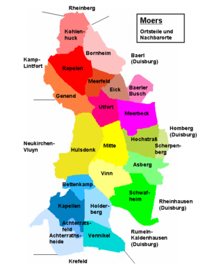
Kohlhuck is a district (officially residential ) of the Rheinkamp district in the north of Moers in the Wesel district in North Rhine-Westphalia .
location
The district borders on the Rheinberg districts of Winterswick and Vierbaum in the north and northeast , Bornheim in the southeast, Repelen in the south and the Kamp-Lintfort district of Rossenray in the west . In the north, the 45-meter-high former is Bergehalde Kohlenhuck. The national road 137 runs east of the heap in a north-south direction. The Moersbach flows through Kohlenhuck in a south-north direction.
history
Kohlhuck owes its name to the Kool or Kohl family, which resided on today's Hermeshof. A land map of the municipality of Rheinkamp shows a “coal huck” south of the Anrath Canal.
There are verifiable traces of the at least temporary residence of people in the area of Kohlenhuck from both the Iron Age and the Roman Age on the Lower Rhine. A few individual finds of flint blades and shards of pottery have been excavated from the Iron Age. Remains of a Germanic settlement have been found in the area of the mining dump from Roman times. These concern the remains of a double row of oak posts, fragments of ceramics, glass and two iron nails. Furthermore, two grave fields were identified at two points, one to the west directly on the Roman road and in the area of the Empeler Berg.
There is documentary evidence of the rural settlement of Kohlenhuck from the Middle Ages . Since then, Kohlenhuck belonged to the parish of Repelen with eight other farmers. In a study from 1830, the peasantry at that time consisted of twenty houses with 162 people. In addition, the Strommoers manor was in the local area.
This large estate is documented from the High Middle Ages. The Strommoers estate was located in the northernmost area of Kohlenhuck am Moersbach (northeast of the mountain dump), which was one of the benefices of monasteries from the High Middle Ages . One of the first verifiable owners was Deutz Abbey . The convent of this abbey sold the property to the Kamp monastery in 1256 . The sale was confirmed by the Archbishop of Cologne Konrad von Hochstaden . The property then remained in the monastery until the secularization , which took place by decree on October 6, 1802. After 1802 the estate was sold by the Prussian domain administration. Verifiable buyers and owners were the Bartels widow in 1810, the Dübler family in 1832 and the Oettinger (or Oettgen) brothers in 1837 and the Kauffmann brothers from Cologne in 1857. The area of the estate was still 345 acres in 1857 . It was a manor until the middle of the 19th century, as the owner at the time, "Oettgen", took part in the 11th Provincial Landtag of the Rhine Province in 1854 as a member of the Knights' vote. After that, the authorization for a manor must have expired, since the owner in the years from 1883 to 1894, "Josef Rotes", is only listed as the landowner in Strommoers. In the meantime, only a small chapel, which was built and consecrated in 1298, remains of the entire former stately property.
Attractions
In the list of architectural monuments in Moers , a monument is listed for Kohlenhuck :
- the Strommoers Chapel (Rheinberger Strasse 689)
Web links
Individual evidence
- ^ Moers - districts and residential areas. Retrieved August 14, 2015 .
- ↑ The earliest mention of the Rheinkamp place names and their interpretation. Retrieved August 14, 2015 .
- ↑ Wensky, Margret, in: Moers. The history of the city from the early days to the present . 2000, Böhlau Verlag, Cologne, Volume 1, pp. 402 + 427-430. ISBN 3-412-04600-0
- ↑ Handbook, in: Die Rheinprovinz der Prussischen Monarchy , 1834, Volume 1, Sixth Book, pp. [219 + 220] 161 + 162.
- ↑ Montanus. In: The prehistory of the countries Cleve-Mark, Jülich-Berg and Westphalia. Chapter XXXV: The chronicle of the Altfeld monastery, vulgo Kamp, in the Duchy of Cleve . 1837, Solingen, p. [74] 438. Online version
- ^ In: Annals of the Historical Association for the Lower Rhine . 1883, issue 39, p. [16] 6. Online version
- ↑ In: Hand-Martrikel of the knightly estates represented in all circles of the Prussian state on district and state parliaments . 1857, Karl F. Rauer (Ed.), P. [434] 422. Online version
- ^ In: 11th Provinzial_Landtag, October 1 to 27, 1854. Negotiations of the Rhineland provincial parliament . 1857, Koblenz, p. [33] 27. Online version
- ^ In: Official Gazette for the Düsseldorf administrative region . 1883, No. 6, p. [42] 36. Online version
- ↑ Montanus. In: The prehistory of the countries Cleve-Mark, Jülich-Berg and Westphalia. Chapter XXXV: The chronicle of the Altfeld monastery, vulgo Kamp, in the Duchy of Cleve . 1837, Solingen, p. [75] 439. Online version
- ↑ The Strommoers Manor Chapel. Retrieved August 15, 2015 .
- ↑ The Strommoers Manor Chapel. Rheinkamp-Repelen, accessed on June 29, 2016 .
- ^ Paul Sippel: Klostergut Strommoers. Excursion tips Rhine-Ruhr, accessed on June 29, 2016 .

