Chapel center
|
Chapel center
City of Moers
Coordinates: 51 ° 28 ′ 17 ″ N , 6 ° 37 ′ 35 ″ E
|
||
|---|---|---|
| Height : | 22 (20-30) m above sea level NN | |
| Residents : | 4961 (December 31, 2015) | |
| Incorporation : | 1st January 1975 | |
| Postal code : | 47447 | |
| Area code : | 02841 | |
|
Location of Kapellen-Mitte in North Rhine-Westphalia |
||
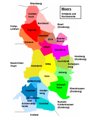
Kapellen-Mitte is the official name for the residential area that forms the center of the Kapellen district in the city of Moers . During the municipal reform of January 1, 1975, the municipality of Kapellen was incorporated into the city of Moers in the Wesel district in North Rhine-Westphalia and three new districts were formed. The southernmost of these three districts is Kapellen . The three districts are divided into a total of 22 residential spaces and “Kapellen-Mitte” is one of them. The area and the current boundaries of the Kapellen-Mitte residential area is largely identical to the “historic” municipality of Kapellen, excluding the hamlets and peasants administered by the mayor's office in the Sammtgemeinde, which existed until December 31, 1974.
location
The Kapellen-Mitte residential area is surrounded by other residential areas in the Kapellen district , with the exception of the west, which borders the Neukirchen-Vluyn town . These are the north of the dwelling place Bettenkamp , east of the living space Holderberg , in the southeast of living space Vennikel , south of the residential space Achterath field and in the southwest of living space Achterath Heide .
history
see → history of chapels
Since Kapellen-Mitte is largely identical to the historical municipality of Kapellen, the explanations given there on the history also apply to the residential area.
Attractions
The list of architectural monuments in Moers contains five architectural monuments for the area of chapels, which concern the Protestant church, a pastorate, a memorial, an old courtyard and a villa with its grounds.
Web links
- City archive Moers
- nbn-resolving.de Digitized edition of the "History of the County of Moers" by Carl Hirschberg
- Grafschafter Museum
- Data and facts in Moers
- http://www.wgff.de/aachen/download/Mairien_im_Departement_La_Roer.pdf
proof
- ^ Moers - districts and residential areas. Retrieved August 15, 2015 .
Remarks
- ↑ The area indicated with Meerfeld on the map is the Rheinkamp-Mitte residential area . Meerfeld is not an official name for a residential area , but is used as a historical local name by municipal institutions and sports clubs in this area.

