Genend
|
Genend
City of Moers
Coordinates: 51 ° 28 ′ 22 " N , 6 ° 35 ′ 41" E
|
||
|---|---|---|
| Height : | 22 (20-25) m above sea level NN | |
| Residents : | 588 (Dec. 31, 2014) | |
| Incorporation : | 1st January 1975 | |
| Postal code : | 47445 | |
| Area code : | 02841 | |
|
Location of Genend in North Rhine-Westphalia |
||
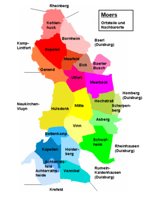
Genend is a district (officially residential ) of the Rheinkamp district in the northwest of Moers in the Wesel district in North Rhine-Westphalia .
location
The district borders in the north and northeast on Repelen , in the east on Meerfeld and Utfort , in the south on Hülsdonk and in the west on Lintfort and the Neukirchen-Vluyner district Dong . The Kamp-Lintfort motorway junction of motorways 42 and 57 is in the north of Genend. The Grafschafter Gewerbepark Genend is centrally located in the sparsely populated and otherwise agricultural district.
history
The place name means "towards the end"; what is meant is the end of the Repelen village or parish area. The place name was first mentioned in a document in 1326 in connection with the name of the estate "Op gen Endt bei der Dongen".
Almost no evidence is available of any settlement or history of the Genend area before the Middle Ages. In contrast to the neighboring area of Sandfort to the south , in which many individual finds from the Iron Age have been identified, in Genend in the Rheim area a burial ground from the early Iron Age can only be identified at one point. This find included remains of urns, bonfire, pots and bowls as well as fragments of ceramic.
The residential area, which is also currently sparsely populated, is still predominantly rural in structure despite the creation of an industrial park. Since there was neither a knight's seat nor a parish of its own in the Middle Ages, there are only a few written reports from this period. However, already after 1125, a farmstead can be documented as a chargeable hooves of the Kamp monastery , which was in the Rheim district.
The local area with a few farms has belonged to the parish Repelen since the Middle Ages . In a study from 1836, the hamlet of Genend with 33 residential buildings and 208 residents and Rheim with 29 residential buildings and 186 residents were still subject to the mayor's office of Repelen in 1834. In 1901, both Genend and Rheim were listed in an address directory as farmers belonging to the Repelen mayor. This affiliation of the two hamlets of Genend and Rheim to the municipality of Repelen did not change after the formation of the entire municipality of Repelen-Baerl in 1910, whose name was changed to Rheinkamp in 1950 . During the municipal reform of the municipality in North Rhine-Westphalia in 1975, the Rheim area was combined with Genend to form the common residential area "Genend" and now belongs to the Rheinkamp district of the city of Moers. The Repeler district of Niephauserfeld, which existed until the reform and connected to Genend to the west, was separated and incorporated into Kamp-Lintfort .
Individual evidence
- ^ Moers - districts and residential areas. Retrieved August 15, 2015 .
- ↑ The earliest mention of the Rheinkamp place names and their interpretation. Retrieved August 15, 2015 .
- ↑ Wensky, Margret, in: Moers. The history of the city from the early days to the present . 2000, Böhlau Verlag, Cologne, Volume 1, p. 411. ISBN 3-412-04600-0
- ↑ Wensky, Margret, in: Moers. The history of the city from the early days to the present . 2000, Böhlau Verlag, Cologne, Volume 1, p. 76. ISBN 3-412-04600-0
- ↑ Vierbahn, Johann Georg von. In: Statistics and topography of the Düsseldorf administrative district, Mayor of Repelen . 1836, Part Two, p. 107.
- ↑ Berenberg. In: Grosses Landes-Adressebuch. 1901, Hannover, p. [1189] 1115. Online version

