Baerler Busch (Moers)
|
Baerler Busch (Moers)
City of Duisburg / Moers
Coordinates: 51 ° 29 ′ 5 ″ N , 6 ° 39 ′ 7 ″ E
|
||
|---|---|---|
| Height : | 26 (33-103) m above sea level NN | |
| Area : | 1.74 km² | |
| Residents : | 67 (December 31, 2015) | |
| Population density : | 39 inhabitants / km² | |
| Incorporation : | 1st January 1975 | |
| Postal code : | 47445 | |
| Area code : | 02841 | |
|
Location of Baerler Busch (Moers) in North Rhine-Westphalia |
||
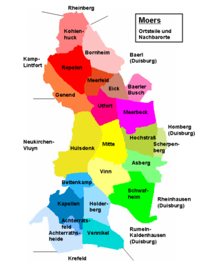
Baerler Busch [ ˈbaːrlər ˈbuʃ ] is the name for a residential area in the city of Moers . The name comes from the adjacent recreational area of the same name in the northwest of Duisburg .
Baerler Busch residential area
Currently, only a small part of the historic district of Baerler Busch belongs to the city of Moers as a residential area . This south-western part, which mainly affects the areas of the Waldsee and the mining dump Rhine Prussia, was separated from the Baerler area on January 1, 1975 when the municipality of Rheinkamp was divided up and assigned to the Moers part. It is located north of the Meerbeck residential area and is surrounded on three sides by Baerler and thus by Duisburg areas. The Baerler Busch residential area is only sparsely populated. The settlement area almost exclusively affects Gutenbergstrasse, which is located southeast of the 103 m high Rhine Prussia dump.
In the area of the living space, traces of temporary human settlement have been found for both the Early and Middle Iron Age . These are mainly in the north-eastern area at the Waldsee. In detail, ceramic shards, a grave field with urn shards and a single bronze sword were excavated at five different locations. In the south-western part of the village, near the Eick residential area, ceramic shards from the Middle Iron Age and a Roman settlement with bricks, ceramic shards, amphorae and a millstone were found at one point.
The district of Baerler Busch belonged to a large forest area that had stretched northeast between Moers and Rheinberg since the Middle Ages . Municipal and ecclesiastical it belonged to the parish of Baerl. Settlement sites were only created in a few small areas and there is largely a lack of written evidence for the area up to the 19th century, as no farmers developed. In a study of the Lower Rhine in 1836, the Baerler Busch was not listed as a hamlet or peasantry, nor in 1901 in a directory of places and addresses. At the beginning of the 20th century, however, there was little settlement. In 1904, the Repelen postal agency listed the Baerler Busch area as well as others for the rural delivery districts to be looked after.
The Baerler Busch, also known as the “Royal Forest”, was a hunting ground for the nobility. For example, in 1841 in the royal Prussian official gazette this hunting area was advertised for leasing. In 1911 the mining company Rheinpreußen acquired the Baerler Busch, which expanded its area for coal mining, which had already sunk the mining pits in the vicinity in Utfort and Hochstraß . No additional mine shaft was built in the Baerler Busch area, but in the adjoining south-eastern area of Gerdt . Here, at the beginning of the 1940s, shaft 8 was constructed as a weather shaft for the coal mines in operation at the Rheinpreussen collieries.
Individual evidence
- ^ Moers - districts and residential areas. Retrieved August 15, 2015 .
- ↑ Wensky, Margret, in: Moers. The history of the city from the early days to the present . 2000, Böhlau Verlag, Cologne, Volume 1, pp. 412/4 + 432. ISBN 3-412-04600-0
- ^ In: Official Gazette for the Düsseldorf administrative region . 1904, No. 46, p. [526] 381. Online version
- ^ In: Official Gazette for the Düsseldorf administrative region . 1841, No. 13, p. [737] 52. Online version
- ^ In: Official Gazette for the Düsseldorf administrative region . 1911, No. 205, p. [2439] 1640. Online version


