Hoske (Wittichenau)
|
Hoske
Hózk City of Wittichenau
Coordinates: 51 ° 21 ′ 56 " N , 14 ° 15 ′ 47" E
|
||
|---|---|---|
| Height : | 129 m above sea level NHN | |
| Area : | 4.02 km² | |
| Residents : | 151 (December 31, 2016) | |
| Population density : | 38 inhabitants / km² | |
| Incorporation : | January 1, 1994 | |
| Postal code : | 02997 | |
| Area code : | 035725 | |
|
Location of Hoske in Saxony |
||
|
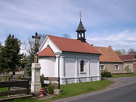
Chapel in Hoske
|
||
Hoske (officially Elsterrode from 1936 to 1947 ), Upper Sorbian , is a district of the city of Wittichenau in the Bautzen district in Saxony . The place is in the recognized Sorbian settlement area .
location
Hoske is located in Upper Lusatia, just under three kilometers southeast of the city of Wittichenau. Surrounding towns are Brischko in the north, the district of Groß Särchen in the east , which belongs to the municipality of Lohsa , Rachlau in the southeast, Kotten in the southwest, Saalau in the west and the city of Wittichenau in the north.
District road 9222 runs through Hoske from Wittichenau to Commerau . Furthermore, the Schwarze Elster flows through the place. Until it was closed in 2001, the Bautzen – Hoyerswerda railway ran through Hoske.
history
Hoske was mentioned in a document as Gosik in 1374 . In the course of time the place name changed from Gossk (1486) to Gößigk (around 1600) and Hosky (1732) to Hoske in 1791. In 1816 the place was mentioned as Goig and Hoßke . In 1937 the National Socialists renamed the place Elsterrode for ideological reasons as part of the Germanization in the German Reich . Since 1947 the place has been called Hoske again.
The chapel in Hoske was built in 1898. From May 1920 until the opening of the new school in Rachlau in 1922, the chapel's premises were used as a classroom for the children from Hoske and Rachlau. The former chapel in Hoske was demolished before the new chapel was completed, but there are no more papers about this former chapel today. The Hosker Chapel has a size of 33.9 m²
After the Congress of Vienna , Hoske came to the Kingdom of Prussia in 1815 . There the place was until July 8, 1945 in the administrative district of Liegnitz . On July 1, 1950, the previously independent community of Rachlau was incorporated. On July 25, 1952, the community of Hoske was assigned to the newly formed Hoyerswerda district in the Cottbus district . After reunification , Hoske was in the Hoyerswerda district in Saxony . On January 1, 1994, Hoske was incorporated into Wittichenau. From January 1, 1996 to July 31, 2008, Hoske was in the district of Kamenz , since the Saxon district reform of August 1, 2008 , the place has been in the district of Bautzen .
population
For his statistics on the Sorbian population in Upper Lusatia, Arnošt Muka determined a population of 230 inhabitants in 1884, all of whom were Sorbs . In 1956, Ernst Tschernik still had a Sorbian-speaking population of 60.8%.
Hoske belongs to the Catholic Upper Sorbian core settlement area and belongs to the parish of Wittichenau.
proof
- ^ Hoske in the Digital Historical Directory of Saxony.Retrieved on May 12, 2017
- ^ Catholic parish of St. Mariä Himmelfahrt Wittichenau: Hoske. In: st-mariae-himmelfahrt-wittichenau.de. Retrieved May 12, 2017 .
- ^ Hoske in the database of the Verein für Computergenealogie. Retrieved May 12, 2017 .
- ↑ Ernst Tschernik: The development of the Sorbian population . Akademie-Verlag, Berlin 1954, p. 91 .
- ^ Ludwig Elle: Language policy in the Lausitz . Domowina-Verlag, Bautzen 1995.


