Huancaspata District
| Huancaspata District | |
|---|---|
 The district of Huancaspata (dark blue) is located in the extreme south of the province of Pataz |
|
| Basic data | |
| Country | Peru |
| region | La Libertad |
| province | Pataz |
| Seat | Huancaspata |
| surface | 242 km² |
| Residents | 6392 (2017) |
| density | 26 inhabitants per km² |
| ISO 3166-2 | PE-LAL |
| politics | |
| Alcalde District | Santos Linder Salazar Vera (2019-2022) |
| Political party | Alianza para el Progreso |
Coordinates: 8 ° 27 ′ S , 77 ° 18 ′ W
The Huancaspata district is located in the Pataz province in the La Libertad region in western Peru . The district has an area of 242 km². The 2017 census counted 6,392 inhabitants. In 1993 the population was 6064, in 2007 it was 6352. The district administration is located in the village of Huancaspata, which is about 2900 m high and has 1268 inhabitants (as of 2017). Huancaspata is located 20 km south of the provincial capital Tayabamba .
Geographical location
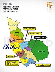
The Huancaspata District is located in the extreme south of the Pataz Province. It is located on the east bank of the Río Marañón , which flows west-northwest, below the confluence of the Río Huacrachucho. In the north, the district is bounded by the Río Huancas. In the east the district extends into the Peruvian Central Cordillera .
The district of Huancaspata borders in the southwest on the districts Parobamba ( Pomabamba province ) and Alfonso Ugarte ( province Sihuas ), in the west on the district Santiago de Challas , in the north on the districts Urpay and Tayabamba and in the south on the district Huacrachuco ( province Marañón ) .
Web links
- Peru: Region La Libertad (provinces and districts) at www.citypopulation.de
- INEI Perú