Ishim (river)
|
Ishim - Jessil Иши́м, Есіл |
||
|
Course of the Ishim in the catchment area of the Ob |
||
| Data | ||
| Water code | RU : 14010300212115300008071 | |
| location |
Karaganda , Aqmola , Northern Kazakhstan ( Kazakhstan ), Omsk Oblast , Tyumen Oblast ( Russia ) |
|
| River system | If | |
| Drain over | Irtysh → Ob → Arctic Ocean | |
| source |
Kazakh threshold 50 ° 38 ′ 4 ″ N , 73 ° 11 ′ 40 ″ E |
|
| muzzle | at Ust-Ishim in the Irtysh coordinates: 57 ° 41 '53 " N , 71 ° 11' 51" E 57 ° 41 '53 " N , 71 ° 11' 51" E
|
|
| length | 2450 km | |
| Catchment area | 177,000 km² | |
| Discharge at the Zelinograd gauge (Astana) A Eo : 7400 km² Location: 2241 km above the mouth |
MQ 1936/1987 Mq 1936/1987 |
5.6 m³ / s 0.8 l / (s km²) |
| Discharge at the gauge Kameny Karer (Jessil) A Eo : 86,200 km² Location: 1,416 km above the mouth |
MQ 1947/1987 Mq 1947/1987 |
44 m³ / s 0.5 l / (s km²) |
| Discharge at the Petropavlovsk A Eo gauge : 106,000 km² Location: 783 km above the mouth |
MQ 1959/1987 Mq 1959/1987 |
48 m³ / s 0.5 l / (s km²) |
| Discharge at the gauge Orechowo A Eo : 133,000 km² Location: 35 km above the mouth |
MQ 1963/1999 Mq 1963/1999 |
83 m³ / s 0.6 l / (s km²) |
| Left tributaries | Terissaqqan | |
| Right tributaries | Koluton , Shabai , Aqqanburlyq , Imanburlyq | |
| Reservoirs flowed through | Astana dam , Sergejew dam | |
| Big cities | Nur-Sultan , Petropavl | |
| Medium-sized cities | Ishim | |
| Small towns | Dershavinsk , Jessil | |
|
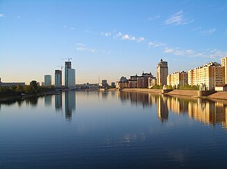
The Ishim / Jessil in Nur-Sultan |
||
The 2,450 km long Ishim ( Russian Иши́м / Есиль; Kazakh Есіл / Jessil ) is a left tributary of the Irtysh in Kazakhstan and Russia ( Asia ).
course
The Ishim rises in Kazakhstan on the northwestern edge of the Kazakh Threshold and initially flows westwards.
The Vyacheslav Reservoir was built 50 km southeast of the Kazakh capital Nur-Sultan for irrigation and electricity generation, and in 2002 the Irtysh-Karaganda Canal was connected to provide further water to the rapidly growing city. 40 km further there is another water reservoir. On reaching the capital, the river receives water from the Nura-Ishim Canal , which flows in here, to supply the local industry and local fish farming.
The Ishim then flows through the government district and business center of Nur-Sultan, which has been newly built since the 1990s, and is artificially widened here to create a more representative impression.
To the west of Nur-Sultan's water again flows - here naturally and about a third of its total amount of water - from the inland delta of the Nura in the south into the Ishim.
Further west near Derschavinsk the river bends sharply to the north and a little later flows past the Kazakh eponymous city of Jessil . Here it is crossed by the southern branch of the Trans-Eurasia route , which is part of the "New Silk Road" from China to Europe. Another 140 km downstream, the Sergejew Dam was built in 1969 to generate electricity and irrigation. In its navigable lower reaches it passes Petropavl and, already on Russian territory, the Russian eponymous city of Ishim . At Ust-Ishim it flows into the Irtysh .
Catchment area and runoff
For the size of its catchment area of 177,000 km², the Ischim has a rather low water flow. It is 215 kilometers from the mouth 56.3 m³ / s (Wikulowo gauge) and a good 35 kilometers from the mouth around 83 m³ / s (Orechowo gauge). A maximum flow of 686 m³ / s was registered at Wikulowo. The upper course lies in the area of the winter cold continental steppes of Inner Asia , towards the mouth of the Ishim the less dry southern taiga surrounds . This explains the significant increase in volume of the river shortly before the mouth.
See also: List of the longest rivers on earth
Web links
- UNESCO Further hydrological data from the Zelinograd gauge (Astana)
Individual evidence
- ↑ a b c Article Ishim in the Great Soviet Encyclopedia (BSE) , 3rd edition 1969–1978 (Russian)
- ↑ a b Ishim in the State Water Directory of the Russian Federation (Russian)
- ↑ Ischim at the Zelinograd gauge - hydrographic data from R-ArcticNET
- ↑ Ischim at the Kameny Karer gauge - hydrographic data from R-ArcticNET
- ^ Ishim at the Petropavlovsk gauge - hydrographic data from R-ArcticNET
- ↑ Ischim at the Orechowo gauge - hydrographic data at R-ArcticNET
- ↑ a b ArcticRIMS gauge Orechowo
- ↑ Серик Ахметов проинспектировал ход реконструкции канала Нура-Ишим . ( bnews.kz [accessed January 19, 2017]). Серик Ахметов проинспектировал ход реконструкции канала Нура-Ишим ( Memento of the original from January 19, 2017 in the Internet Archive ) Info: The archive link has been set up automatically and has not yet been checked. Please check the original and archive link according to the instructions and then remove this notice.
- ↑ Минсельхоз выпустит более 160 млн ценных рыб в водоемы республики в 2011 году . ( bnews.kz [accessed January 19, 2017]).
- ↑ The catchment areas and water network of Nura and Ischim. In: National Integrated Water Resource Management and Water Efficiency Plan for Kazakhstan. UNDP (United Nations Development Program), February 15, 2017, accessed February 15, 2017 (Russian).


