Izu (Shizuoka)
| Izu-shi 伊豆 市 |
||
|---|---|---|
| Geographical location in Japan | ||
|
|
||
| Region : | Chūbu | |
| Prefecture : | Shizuoka | |
| Coordinates : | 34 ° 59 ' N , 138 ° 57' E | |
| Basic data | ||
| Surface: | 363.97 km² | |
| Residents : | 29,262 (October 1, 2019) |
|
| Population density : | 80 inhabitants per km² | |
| Community key : | 22222-4 | |
| Symbols | ||
| Tree : | Japanese chestnut oak | |
| Flower : | Wasabi | |
| Bird : | Colored pheasant | |
| town hall | ||
| Address : |
Izu City Hall 38 - 2 , Koda Chino Izu -shi Shizuoka 410-2413 |
|
| Website URL: | http://www.city.izu.shizuoka.jp | |
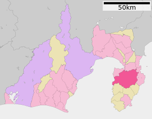
| Location of Izus in Shizuoka Prefecture | ||
Izu ( Japanese 伊豆 市 , -shi ) is a city in Shizuoka Prefecture in Japan . It is located on the Izu Peninsula on the upper reaches of the Kano River near the Amagi volcano , a popular tourist area.
history
The city of Izu was founded on April 1, 2004 as a merger of Shuzenji (city since 1924), Toi (city since 1924), Nakaizu (city since 1958) and Amagiyugashima (city since 1960).
traffic
Izu can be reached via the Izu-Jūkan motorway and national roads 136 and 414. The Shuzenji train station is in the district Kashiwakubo the terminus of Sunzu line of the railway company Izuhakone tetsudō .
Attractions
- Shuzenji Onsen (Hot Spring )
Personalities
- Mokutarō Kinoshita (1885-1945), leprosy researcher and author
- Seiichi Furuya (* 1950), photographer
Neighboring cities and communities
Web links
Commons : Izu - collection of images, videos and audio files


