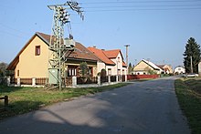
Janovičky (Zámrsk)
| Janovičky | ||||
|---|---|---|---|---|
|
||||
| Basic data | ||||
| State : |
|
|||
| Region : | Pardubický kraj | |||
| District : | Ústí nad Orlicí | |||
| Municipality : | Zámrsk | |||
| Area : | 204 ha | |||
| Geographic location : | 50 ° 0 ′ N , 16 ° 6 ′ E | |||
| Height: | 253 m nm | |||
| Residents : | 97 (2011) | |||
| Postal code : | 565 43 | |||
| License plate : | E. | |||
| traffic | ||||
| Street: | Týnišťko - Vraclav | |||
| Railway connection: | Česká Třebová – Praha | |||
Janovičky (German Janowitz , also Janowitschek ) is a district of the municipality of Zámrsk in the Czech Republic . It is located six kilometers northwest of Vysoké Mýto and belongs to the Okres Ústí nad Orlicí .
geography
The Rundling Janovičky is located on the left bank of the Loučná on the Choceňská tabule ( Chotzener panel ). To the south rise the Kamenec (337 m nm) and the Homole (304 m nm). North of the village passing railway Česká Třebová-Praha , in the East State Road I / 35 / E 442 between Holice and Vysoké Mýto as well as the south, the I / 17 between Hrochův Týnec and Nova Ves . To the southwest lies the Malejovák pond.
Neighboring towns are Týnišťko in the north, Rzy in the northeast, Nádraží Zámrsk in the east, Zámrsk and Nová Ves in the southeast, Svatý Mikuláš in the south, Malejov and Stradouň in the southwest, Radhošť in the west and Žíka , Franclina and Bory in the northwest.
history
The first written mention of Janovičky was in 1244. Since the 16th century, the village belonged to the Chroustovice estate . The owners were Messrs. Slavata von Chlum and Koschumberg ; later the Choltitz family branch of the von von Gersdorff family , whose goods were confiscated after the battle of the White Mountain . From 1671 the Chroustovice estate belonged to Count Kolowrat-Liebsteinsky ; Franz Karl Kolowrat-Liebsteinsky sold it to Hieronymus Graf Capece Marchese de Rofrano in 1721. His daughter Maria Theresia Capece married Leopold Ferdinand Johann Graf Kinsky in 1735 ; In 1778 her son Philipp Graf Kinsky inherited the rule. In 1823 Kinsky sold the allodial rule Chraustowitz with 23 villages to Karl Alexander von Thurn und Taxis .
In 1835, the in consisted Chrudim District village located Janowitz , even Janowitschek or Janowičky called, of 23 houses, in which 110 people, including a Jewish family lived. The single-layer Meierhof Malegow ( Malejov ) and a mill were included in Janowitz . A quarry was operated on Mount Homile ( Homole ), which is planted with fruit trees . The parish was Wratzlaw . Until the middle of the 19th century the village remained subject to the allodial rule of Chraustowitz.
After the abolition of patrimonial Janovičky formed from 1849 a district of the municipality Týnišťko in the judicial district Hohenmauth . From 1868 the village belonged to the political district Hohenmauth . In 1869 Janovičky had 211 inhabitants and consisted of 29 houses. The village broke away from Týnišťko in the 1870s and formed its own municipality. In 1900 there were 158 people living in Janovičky, in 1910 there were 167. At the beginning of the 20th century, the train station settlement was built to the east of the Zámrsk train station, the western part of which is in the Janovičky district. In 1930 the community had 192 inhabitants. In 1960 Janovičky was assigned to the Okres Ústí nad Orlicí . On January 1, 1962, it was incorporated into Zámrsk . In the 2001 census, there were 117 people in Janovičky’s 42 houses.
Local division
The district Janovičky consists of the basic settlement units Janovičky and Nádraží Zámrsk-západ. Janovičky also includes the one- shift Malejov ( Malejow ).
The district forms the cadastral district Janovičky u Zámrsku.
Attractions
- Neo-Gothic chapel of the Virgin Mary in the village square, built in 1864
- Storage room of homestead no.18
literature
- Historický lexikon obcí České republiky 1869–2005 , part 1, p. 548
Web links
Individual evidence
- ↑ http://www.uir.cz/katastralni-uzemi/790931/Janovicky-u-Zamrsku
- ^ Johann Gottfried Sommer : The Kingdom of Bohemia; Represented statistically and topographically. Volume 5: Chrudimer Kreis. Prague 1837, p. 111
- ↑ http://www.uir.cz/zsj-casti-obce/190934/Cast-obce-Janovicky
- ↑ http://www.uir.cz/katastralni-uzemi/790931/Janovicky-u-Zamrsku


