
Kebnekaise
| Kebnekaise | ||
|---|---|---|
 Kebnekaise (seen from Tuolpagorni ) |
||
| height | 2097 m o.h. | |
| location | Sweden | |
| Mountains | Scandals | |
| Coordinates | 67 ° 54 '3 " N , 18 ° 31' 0" E | |
|
||
| First ascent | 1883 by Charles Rabot | |
| Normal way | Westweg; if the conditions are good, easy high-altitude tour (partly glaciated) | |
| particularities | highest mountain in Sweden | |

The Kebnekaise ( Sami Giebnegáisi or Giebmegáisi , in German about "Kessel-Kamm") is the highest mountain in Sweden at 2097 meters (northern summit, consisting of rock) . In the past, the glaciated south summit was higher than the north summit; (it has been measured since 1880); In 2018, due to global warming and the resulting glacier melt, it will be lower than the northern summit for the first time.
The Kebnekaise is the center and highest point of the Kebnekaise massif in the northern part of the Scandinavian Mountains and is located in Lapland , about 150 kilometers north of the Arctic Circle and about 70 km west of Kiruna . In August 2018, the glaciated southern summit was lower than the northern summit for the first time since measurements began. This made the latter the highest point in Sweden.
From the starting point in Nikkaluokta it is about 19 kilometers, mostly easy to walk, to the Kebnekaise fjällstation , whereby 6 km can be covered by boat at Lake Ladtjojaure. 13 km behind the Kebnekaise fjällstation the path meets the popular Kungsleden hiking trail at Singi .
About two kilometers past the mountain station on the way to Singi there are two ways to reach the summit:
- Västra Leden - Kebnekaise
- The western (normal) path leads exclusively over stony slopes and over the Vieranvarri pre-summit to the glaciated summit pyramid. On this route you have to accept a strong and exhausting loss of altitude behind the Vieranvarri. The one-way route is about ten kilometers long, for which five to seven hours (depending on condition and weather conditions) must be allowed for.
- Östra Leden - Kebnekaise
- This route leads over glaciers and rocky passages (I to II. Level of difficulty according to UIAA ) and includes fixed , via ferrata-like iron wires and safety devices at lofty heights. This route is only recommended for inexperienced mountaineers with a mountain guide - this can be booked at the Kebnekaise fjällstation. The one-way route is about seven kilometers long, and it takes four to six hours to get to the top.
A third path, called Durlings led, starts from the Kungsleden between the Singi and Sälka huts . This path does not require any climbing and avoids the detour via the Vierranvarri.
In front of the Kebnekaise is the Tuolpagorni mountain (1662 m). On the eastern flank of the mountain, in the valley of Tarfala, there is a glaciological research station, where you can also spend the night in a seasonal hut.
North of the latitude on which the Kebnekaise lies, there are no longer any higher mountains in all of Eurasia . Due to the special location, when the weather is clear, you can see approx. 10% of the entire Swedish national territory from the summit, which is more than the entire area of Switzerland .
The name is also known in connection with the novel The wonderful journey of little Nils Holgersson with the wild geese by Selma Lagerlöf and the cartoon series based on it. The leading goose is called " Akka von Kebnekaise" there.
On March 15, 2012, there was an accident with a transport aircraft on Kebnekaise . The machine of the type Lockheed C-130 Hercules of the Norwegian armed forces collided with the west side of the mountain a little below the ridge between the north and south peaks; the five inmates were killed. The aircraft took part in a military maneuver and was en route from Harstad / Narvik Airport in Evenes to Kiruna in bad weather conditions .
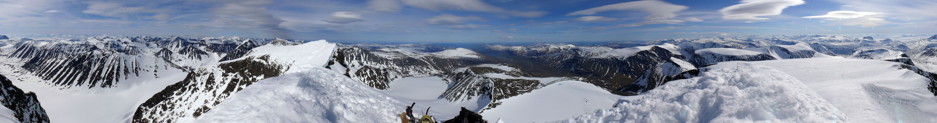
Panoramic view from the top of the mountain, June 2007


View of Kebnekaise sydtoppen

View from Sydtoppen (2104 m) to the west

View from the east over the lake Ladtjojaure to the Kebnekaise massif

Inspection of the Kebnekaise in the first half of the 20th century


Web links
- Välkommen till Kebnekaise on kebnekaise.nu (Swedish)
- Kebnekaise on summitpost.org (English)
- Kebnekaise thaws and shrinks on spiegel.de (German)
Individual evidence
- ↑ The south summit of Kebnekaise keeps moderation. Sydsvenskan , July 24, 2016 (Swedish)
- ↑ spiegel.de August 3, 2018: The highest point in Sweden has thawed away . (see also drought and heat in Europe 2018 , glacier retreat since 1850 )
- ↑ New measurement: north summit highest. By: Sveriges television , August 6, 2018 (Swedish).
- ↑ Statens haverikommission: Preliminär faktasammanställning ( Memento from November 1, 2013 in the Internet Archive ) (PDF file; 2.6 MB) Statens haverikommission , May 11, 2012 (Swedish)