Suburb (Kiel)
|
Suburb
City of Kiel
Coordinates: 54 ° 19 ′ 9 ″ N , 10 ° 8 ′ 1 ″ E
|
|
|---|---|
| Area : | 46.2 ha |
| Residents : | 1165 (Dec. 31, 2014) |
| Population density : | 2,522 inhabitants / km² |
| Postal code : | 24103 |
| Area code : | 0431 |
|
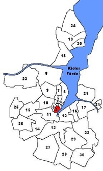
Location of suburb in Kiel
|
|
The suburb is a district of Kiel .
history
Three hundred and thirty years after the city was founded, the old town area was so densely built that in 1572 the first Kiel citizen was given the right to settle outside. Since the town of Brunswik already existed in the north, the fjord in the east and the Kleine Kiel in the west , for a long time it was only possible to expand in a southerly direction across the Holsten Bridge. Irregular buildings began on the existing dirt roads up to the Kuhberg. Kuhstede developed - later called Vorstadt. The inauguration of the university in 1665 reports on the village of Kuhberg. This village can still be found today under the street name Kleiner Kuhberg . The Holsten Bridge was demolished and the Holsten Fleet will be built in its place.
District boundaries
The district of Vorstadt is bordered in the north by Rathausstrasse and Holstenbrücke. The Kleine Kiel and the boat harbor are also north of the city limits . In the east, the Kiel Fjord forms the border. In the south, the district is bounded by Raiffeisenstraße, Sophienblatt and Ringstraße, and in the west by the Schülperbaum and the Sandkuhle. The parade ground lies to the west of the city limits, the Sparkassen-Arena itself, formerly known as the Ostseehalle , with the Europaplatz to the southeast, lies in the district of Vorstadt .
Buildings
- town hall
- Opera house
- Sparkassen-Arena - (major event location, former Ostseehalle)
- Sophienhof - shopping center
Lost structures
- Thaulow Museum am Ziegelteich, demolished in May 1948 after being destroyed in the war
See also
Individual evidence
- ↑ The population in the Kiel districts in 2014 . (PDF) State capital Kiel
- ↑ Vera Stoy: Kiel on the way to the big city. Kiel 2003.
- ↑ Hans-G. Hilscher, Dietrich Bleihöfer: Large cow mountain. In: Kiel Street Lexicon. Continued since 2005 by the Office for Building Regulations, Surveying and Geoinformation of the State Capital Kiel, as of February 2017 ( kiel.de ).
- ↑ City map of the city of Kiel published by the city of Kiel with detailed district boundaries.
Web links
- Kieler Vorstadt in the Stadtwiki Kiel

