Kirksville, Missouri
| Kirksville | |
|---|---|
![Adair County Courthouse in Kirksville, listed on the NRHP since 1978 [1]](https://upload.wikimedia.org/wikipedia/commons/thumb/1/10/Adair_County_Courthouse.jpg/298px-Adair_County_Courthouse.jpg) Adair County Courthouse in Kirksville, listed on the NRHP since 1978 |
|
| Location in Missouri | |
| Basic data | |
| Foundation : | 1848 |
| State : | United States |
| State : | Missouri |
| County : | Adair County |
| Coordinates : | 40 ° 12 ′ N , 92 ° 35 ′ W |
| Time zone : | Central ( UTC − 6 / −5 ) |
| Residents : | 17,505 (as of 2010) |
| Population density : | 645.9 inhabitants per km 2 |
| Area : | 27.2 km 2 (approx. 11 mi 2 ) of which 27.1 km 2 (approx. 10 mi 2 ) are land |
| Height : | 299 m |
| Postal code : | 63501 |
| Area code : | +1 660 |
| FIPS : | 29-39026 |
| GNIS ID : | 735678 |
| Website : | www.kirksvillecity.com |
| Mayor : | Richard L. Detweiler |
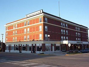
 Travelers Hotel in Kirksville, listed in the NRHP since 2009 |
|
Kirksville is a city and county seat of Adair County in the north of the US -amerikanischen state of Missouri . At the 2010 census , Kirksville had 17,505 residents.
Kirksville is home to the state Truman State University and the private A. T. Still University .
geography
Kirksville lies at 40 ° 11'37 "north latitude and 92 ° 34'58" west longitude and extends over 27.2 km², which consists almost entirely of land. Kirksville is a few miles west of the Chariton River , a tributary of the Missouri .
Neighboring towns are Novinger (14.7 km west-northwest), Greentop (17.8 km north), Sperry (17.3 km northeast), Clay (14 km north-northeast), Millard (11.1 km south), Yarrow (12 miles southwest) and Youngstown (10 miles west).
The nearest major cities are Quincy in Illinois (119 km east-northeast), St. Louis (329 km southeast), Missouri's capital Jefferson City (196 km southeast), Kansas City (290 km southeast), Omaha , Nebraska (409 km) km northwest), Des Moines , Iowa (150 miles northwest), and the Quad Cities in Iowa and Illinois (315 miles northeast).
traffic
US Highway 63 runs north-south as a bypass around central Kirksville. Missouri State Routes 6 and 11 intersect in the city center .
South on the 13 km of the city near the village Millard located Kirksville Regional Airport has Kirksville connection to the national air network.
In La Plata, about 22 km south-southwest, there is an Amtrak station on a route maintained by the BNSF Railway , where the Southwest Chief long- distance express train stops.
Demographic data
| Population development | |||
|---|---|---|---|
| Census | Residents | ± in% | |
| 1860 | 658 | - | |
| 1870 | 1471 | 123.6% | |
| 1880 | 2314 | 57.3% | |
| 1890 | 3510 | 51.7% | |
| 1900 | 5966 | 70% | |
| 1910 | 6347 | 6.4% | |
| 1920 | 7213 | 13.6% | |
| 1930 | 8293 | 15% | |
| 1940 | 10,080 | 21.5% | |
| 1950 | 11,110 | 10.2% | |
| 1960 | 13,123 | 18.1% | |
| 1970 | 15,569 | 18.6% | |
| 1980 | 17.167 | 10.3% | |
| 1990 | 17,152 | -0.1% | |
| 2000 | 16,988 | -1 % | |
| 2010 | 17,505 | 3% | |
| 1860-1990 2000-2010 | |||
As of the 2010 census , Kirksville had 17,505 people in 6,512 households. The population density was 645.9 people per square kilometer.
The racial the population was composed of 92.3 percent white, 2.2 percent African American, 0.2 percent Native American, 0.4 percent Asian and other ethnic groups; 2.0 percent were descended from two or more races. Hispanic or Latino of any race was 2.7 percent of the population.
Statistically, 2.22 people lived in each of the 6,512 households.
16.4 percent of the population were under 18 years old, 72.4 percent were between 18 and 64 and 11.2 percent were 65 years or older. 53.9 percent of the population was female.
The median income for a household was 26,865 USD . The per capita income was $ 15,209. 31.8 percent of the population lived below the poverty line.
Known residents
- Samuel W. Arnold (1879-1961) - Member of the US - House of Representatives (1943-1849) - lived most of his life in Kirksville
- Gordon Bell (born 1934) - computer engineer and manager - born in Kirksville
- Anthony Cistaro (born 1963) - actor - born in Kirksville
- Charles F. Cochran (1846-1906) - Member of the US - House of Representatives (1897-1905) - born in Kirksville
- Marguerite Hedberg (1907–2002), mathematician and university professor - born in Kirksville
- Rusty Draper (1923–2003) - country musician - born in Kirksville
- Geraldine Page (1924–1987) - actress, Oscar winner - born in Kirksville
- Andrew Taylor Still - founder of alternative medicine osteopathy - died in Kirksville
- Rhonda Vincent (born 1962) - bluegrass musician - born in Kirksville
Individual evidence
- ↑ Extract from the National Register of Historic Places - No. 78001636 Retrieved January 31, 2012
- ↑ Extract from the National Register of Historic Places - No. 09000718.Retrieved January 31, 2012
- ↑ a b c U.S. Census Bureau, State & County QuickFacts - Kirksville, MO ( Memento of the original from October 24, 2011 in the Internet Archive ) Info: The archive link was automatically inserted and has not yet been checked. Please check the original and archive link according to the instructions and then remove this notice. Retrieved January 31, 2012
- ↑ Google Maps. Retrieved January 31, 2012
- ^ Decennial Census of Populations and Housing.Retrieved January 31, 2012
