
Fortifications on the Klüt


The fortifications on the Klüt , also called Fort George or Klütfestung , were on the elevation of the Klüt to the west of Hameln . The complex, built at the end of the 18th century, consisted of four forts . They served the military protection of on the opposite bank of the Weser located fortress Hameln . Hameln thus became the strongest fortress in the Electorate of Hanover and was known as the “ Gibraltar of the North” at the end of the 18th century . Following a decree by Napoleon , the fortifications on the Klüt and those of the city of Hameln were razed in 1808 .
history

During the Seven Years' War there was the battle of Hastenbeck near Hameln in 1757 , as a result of which the Hameln Fortress surrendered to the French troops. They occupied Hamelin for about two years. After their departure and during the Seven Years' War, Elector George III. , after which the entire complex was named, continued to expand and strengthen the Hamelin fortifications from 1760 onwards. The elevation of the Klüt was included because of its strategic importance for the defense of the city. First, from 1760, Fort I (Fort George) was built on the summit of the Klüt. Between 1774 and 1784, Fort II (Fort Wilhelm) and Fort III were followed by two more facilities on the Klüt mountain slope. The erection of the fortifications on the mountain was provisionally completed with the construction of the three independent structures in 1784. As a supplement, Fort IV (Fort Luise) was built at the foot of the mountain near the Weser Bridge in 1806 .

In November 1806, during the Fourth Coalition War , French troops approached the fortress of Hameln, where Prussian troops had gathered around 9,000 soldiers at that time . There were individual outpost skirmishes and skirmishes in the area around Hameln, in which cannons from Fort I and II also fired at the attackers. Under the impression of the defeat in the battle of Jena and Auerstedt , the Prussian troops in Hameln surrendered on November 20, 1806 under General Le Coq almost without a fight, despite the numerically inferior French of General Savary with about 6000 men. There was also an uproar among the Prussian soldiers, who were drunk, looting and shooting through the streets of the city when they learned that the officers were to be escorted and that, according to the terms of surrender, they were to be taken prisoner to France. An eyewitness to the incidents was the scholar Adelbert von Chamisso , who was an officer in the fortress and was released as a prisoner on his word of honor.
In 1808 the fortress Hameln including the fortifications on the Klüt was razed . To this end, Napoleon issued a decree to his Secretary of War, Clarke , in which he instructed him to blow up and remove the fortifications and the barracks. During the grinding, the surface stone material was completely removed by around 1,000 workers, other sources speak of up to 4,000 workers. The stones were still sold 20 years after the demolition work and were used to construct other buildings. The Klütturm , the new forest building on Finkenborn at the end of the 19th century and the building on the Ohrberg were built with the stones from Klüt in 1843 . In the 1870s, an inn was built on the Klütturm, which is still there today as a follow-up building. From around the 1820s the Klüt was reforested .
description
The fortifications on the Klüt included four forts, which were lined up on the narrow ridge sloping down to the Weser at some distance from one another. They were connected to one another by above and below ground corridors. On the flanks and in the immediate vicinity there were upstream defenses with two watchtowers and four smaller sporadically occupied entrenchments . The remains of two star jumps have been preserved as earth walls near the forest clearing of the Finkenborn . As a protection against hostile approach also served mine galleries , barricades and palisades . At that time the Klüt was free of trees to give the defenders a clear field of fire. All forts had casemates in the ramparts and two forts had deep wells. In 1803 the crew of the fortifications on the Klüt included almost 90 officers and over 3,000 soldiers. The armament consisted of cannons , howitzers and mortars .
Fort I


Fort I ( 52 ° 5 ′ 42.5 ″ N , 9 ° 20 ′ 18.2 ″ E ) , named Fort George after King George III , was at the highest point on the summit of the Klüt . wore. It was in the area where the Klütturm and a restaurant are located today. The fort, built between 1760 and 1762, was a hexagonal Sternschanze accessible via a drawbridge. A trench, which was defended by a battery , served as a connection to Fort II . The casemates could accommodate a crew of up to 1200 men. The armament consisted of 40 guns. The fort was built of ashlar, with the parapets made of brick . In the middle of the fort was the commandant's house, under which there was a 160 meter deep well. It was locked in 1965; the wreath is still visible. The place is preserved as a wall with a brick archway, which was restored in the years 2008/2009 by the Hamelin Association for Border Relationship and Homeland Care from 1930 . During the construction work carried out in 2009 to renovate the catering building in the area of the fort, the remains of a casemate that had probably been blown up and a buried corridor were found.
Fort II
Approximately half the height of the ridge of the Klüt was 1774 finished Fort II. ( 52 ° 5 '39.4 " N , 9 ° 20' 40.4" O ) It is to Graf Wilhelm Schaumburg-lip as Fort Wilhelm named. The complex had walls three meters thick and a well that was 138 meters deep. The armament included 21 guns, as well as two watchtowers down the slope, to which an open corridor with stairs led. An underground passage ran from Fort II to Fort III in the area of the Kanonenweg. Its remains were cut during earthworks in 2009.
Fort III
Fort III ( 52 ° 5 ′ 38.8 ″ N , 9 ° 20 ′ 55.7 ″ E ) was further below at the foot of the Klüt, but above the former rock cellar . It had 15 guns. An open-air stage with 1200 seats was built inside the fort in 1939 , which no longer exists today. A water supply system is now located within the former fort .
Fort IV
Fort IV ( 52 ° 5 ′ 33.4 ″ N , 9 ° 21 ′ 7.9 ″ E ) , completed in 1806, was located at the foot of the mountain and closed the gap between Fort III, located above the slope, and the Weser. It was not a closed system, but a front work with a ditch that blocked the road upstream in the direction of the Ohrberg. The trench could be passed over a narrow bridge. The traffic was monitored from a guardhouse with a bulletproof ceiling. The system was armed with five cannons. The connection to Fort III was made possible by trenches with parapets. Fort IV was after the Prussian Queen Luise in the vernacular Luise Fort called. It only lasted a short time, as it was razed after Hameln's surrender to French troops in 1808, just two years after completion.
Remnants and today's situation
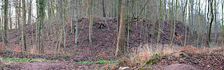
When the fortifications on the Klüt were razed in 1808, most of the stone material was removed. By excavations in 1982 was evidence that the buildings were up to the foundations removed. Larger, above-ground building remains made of stone can only be found today in the form of an archway to Fort I, where the commandant's house stood with a well below.
On the other hand, earth walls with steep embankments, earth entrenchments and individual trenches have been well preserved . Their contours are still clearly visible in the terrain. The remains of the fortifications are now almost completely under forest. Information boards or signs are set up on some systems. Permanent damage to parts of the fortress has recently been threatened by mountain biking over ramparts and rubble mounds. In the past, robbery excavations caused damage due to the uncovering of building remains.
Today little is known about the fortifications on the Klüt, as no systematic research has been carried out in the archives or in the area. In the future, tourist upgrading of the Klüt is planned, with which the former fortress character can also be experienced again. A concept developed by the city of Hameln in 2012 has not yet been implemented (2015).

Archway of Fort I (Fort George) as the only stone remains of the fortifications
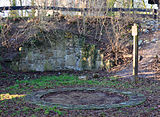
Well ring of the 160 meter deep well of Fort I.

Information sign at Fort II (Fort Wilhelm) with stone remains on the ground

The Klütturm made of stones from Fort I.


Wall and surrounding moat of Fort III

literature
- Letter to a friend about the new works that have been listed since the end of the war in 1756 to strengthen the Hameln Fortress in Hanover. In: Zeitschrift für Kunst, Wissenschaft, und Geschichte des Krieg. Volume 25, 1832 (Online, from page 20)
- Erich Karwiese: The Hameln Fortress 1618–1806. Hameln / Leipzig 1911.
- Gerhard Pieper: Hameln Fortress. History, buildings and institutions. Hameln 2006, ISBN 3-8271-9303-6 .
- Viktor Meissner: Gibraltar of the North. Hameln Fortress, Hameln City Archives, booklet accompanying the exhibition, 2006.
- Günther Gebhardt: Fort George near Hameln in: Military affairs, economy and traffic in the middle of the Electorate and Kingdom of Hanover 1692-1866. , Stuttgart, 2010, pp. 15-18 ( online )
Web links
- The mountain fortress from 1760–1808 at hamelner-geschichte.de
- Reconstruction drawing by Wolfgang Braun
- Painting from the area of Fort George and the fortress of Hameln around 1800
Individual evidence
- ^ City history of Hameln
- ↑ Großer Generalstab (Ed.): 1806 - The Prussian officer corps and the investigation of the war events. Ernst Siegfried Mittler and Son, Berlin 1906.
- ↑ The garrison in the Pied Piper City
- ↑ See literature: Viktor Meissner: Gibraltar of the north. The end of Hameln Fortress, p. 28
- ↑ The Finkenborn
- ^ The mountain fortress from 1760–1808
- ↑ The Finkenborn
- ↑ a b Joachim Schween: The Klütfestung part I
- ↑ The open-air stage at the Rittersprung
- ↑ Joachim Schween: The Klütfestung Part II
- ↑ Tourism on the Klüt - there is more in: Deister and Weser newspaper from October 20, 2010.
Coordinates: 52 ° 5 ′ 41.9 ″ N , 9 ° 20 ′ 18.1 ″ E