Little Steinau
| Little Steinau | ||
|
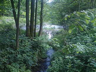
Mouth of the Kleine Steinau (front) into the Sieber |
||
| Data | ||
| location | in the district of Göttingen , Lower Saxony ( Germany ) | |
| River system | Weser | |
| Drain over | Sieber → Oder → Rhume → Leine → Aller → Weser → North Sea | |
| source | between the shingle head and the philistine cliff ( on the field ) 51 ° 43 ′ 3 ″ N , 10 ° 20 ′ 44 ″ E |
|
| Source height | approx. 640 m above sea level NHN | |
| muzzle | at Aschenhütte in the Sieber coordinates: 51 ° 40 ′ 25 ″ N , 10 ° 18 ′ 7 ″ E 51 ° 40 ′ 25 ″ N , 10 ° 18 ′ 7 ″ E |
|
| Mouth height | approx. 210 m above sea level NHN | |
| Height difference | approx. 430 m | |
| Bottom slope | approx. 49 ‰ | |
| length | 8.7 km | |
| Left tributaries | Big sweat | |
The Kleine Steinau , also known as Schindelgraben and Schindelar in the upper reaches , in the community-free area of Harz in the Lower Saxony district of Göttingen, is an 8.7 km long, northern and orographically right tributary of the Sieber in the Harz low mountain range and at the southwestern Harz foot.
course
The Kleine Steinau rises in the Upper Harz in the Harz Nature Park in the southeast of the Acker ridge , which is a maximum of 690 m above sea level. NHN is high. Its source is about 6.5 km east-southeast of Osterode am Harz, which is not traversed by the stream, between the Schindelkopf in the northwest and the Spießerklippe in the southeast at an altitude of about 640 m .
First, the Kleine Steinau flows in a westerly direction , then - when you pass the Katzenklippe - in a south-westerly direction and a little later in a southerly direction through the wooded Harz landscape. After the confluence of the Große Schweimke and passing the forester's house Rehhagen , it leaves the nature park by crossing under the Herzberg – Seesen railway line and the 243 federal road in quick succession . The stream enters the southwestern Harz foreland .
A little after passing under the district roads 7 ( Mühleberg - Aschenhütte ) and 27 (Osterode am resin Herzberg ) opens the Small Steinau about 3.3 km northwest of Herzberg and 750 m west-northwest the mouth of the Great Steinau when Hördener Weiler Aschenhütte on around 210 m above sea level in the Sieber tributary of the Oder , which flows from the southeast .
Individual evidence
swell
- Topographic map 1: 25000, No. 4228, Riefensbeek
- Topographic map 1: 25000, No. 4227, Osterode in the Harz region
- Topographic map 1: 25000, No. 4327, Gieboldehausen
