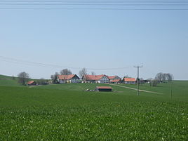
Kornhofen
|
Kornhofen
Market Bad Groenenbach
Coordinates: 47 ° 51 '14 " N , 10 ° 13' 50" E
|
|
|---|---|
| Height : | 753 m above sea level NN |
| Residents : | 19 (1987) |
| Postal code : | 87730 |
| Area code : | 08334 |
|
Kornhofen
|
|
Kornhofen is a district of the Bad Grönenbach market in the Unterallgäu district in Bavaria .
geography
location
The hamlet is about three kilometers south of Bad Grönenbach. In the southwest it borders on the village of Herbisried , in the south on Gmeinschwenden , and further east on Hueb , Seefeld and the village of Ziegelberg . A connecting road leads to the MN 24 county road to the west .
geology
Kornhofen lies on a young moraine with terminal moraine lines from the Worm Ice Age of the Pleistocene . The subsoil partly contains gravel and gravel as well as sand , clay and silt .
history
Kornhofen was mentioned for the first time in 1512. The hamlet was created by a clearing settlement in the 11th / 12th. Century.
Architectural monuments
In the village there is the listed chapel of St. Anna from 1772. It was built by the Kemptic builder Franz Benedict Stark. The band is provided with a saddle roof covered and has a semi-circular chorus circuit . The roof turret over the north gable has a curved hood.
literature
- Hermann Haisch (Ed.): Landkreis Unterallgäu . Memminger Zeitung Verlagsdruckerei, Memmingen 1987, ISBN 3-9800649-2-1 , p. 1018 .
Web links
Individual evidence
- ^ Geological map of Bavaria 1: 500,000. Bavarian State Ministry of Finance, Regional Development and Homeland, accessed on November 22, 2015 .
- ^ Bavarian State Office for Monument Preservation: Entry D-7-78-144-34


