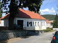
Košariská
| Košariská | ||
|---|---|---|
| coat of arms | map | |

|
|
|
| Basic data | ||
| State : | Slovakia | |
| Kraj : | Trenčiansky kraj | |
| Okres : | Myjava | |
| Region : | Záhoria | |
| Area : | 11.53 km² | |
| Residents : | 431 (Dec. 31, 2019) | |
| Population density : | 37 inhabitants per km² | |
| Height : | 349 m nm | |
| Postal code : | 906 15 | |
| Telephone code : | 034 | |
| Geographic location : | 48 ° 41 ' N , 17 ° 36' E | |
| License plate : | MY | |
| Kód obce : | 504467 | |
| structure | ||
| Community type : | local community | |
| Administration (as of November 2018) | ||
| Mayor : | Štefan Antol | |
| Address: | Obecný úrad Košariská 78 Košariská |
|
| Website: | www.kosariska.sk | |
| Statistics information on statistics.sk | ||
Košariská (Hungarian Kosaras ) is a municipality in western Slovakia .
Location and general
The name of the village was mentioned for the first time in 1263 and it is divided into Dolné Košariská in the west and Horné Košariská further east.
The municipality is located in the hill country between the Little Carpathians in the south and the White Carpathians in the north. Nové Mesto nad Váhom is about 30 kilometers east of the municipality, Myjava about 10 kilometers north, Senica about 20 kilometers west.
Until 1927, the place was part of the western town of Brezová pod Bradlom , then until 1957 with the place Priepasné as well as in the community association with Brezová to form the double place Košariská-Priepasné.
The most famous son of the place is Milan Rastislav Štefánik, born here in 1880 .
There is a church from 1878 and a museum about the Slovak politician Štefánik.


