
Krasnogorodsk
| Urban-type settlement
Krasnogorodsk
Красногородск
|
||||||||||||||||||||||||||||||||||
|
||||||||||||||||||||||||||||||||||
|
||||||||||||||||||||||||||||||||||
.png)
.svg)

Krasnogorodsk ( Russian Красногоро́дск ) is an urban-type settlement in the Pskov Oblast in Russia with 3870 inhabitants (as of October 14, 2010).
geography
The place is about 110 km as the crow flies south of the Pskov Oblast Administrative Center, about 20 km from the state border with Latvia on the Sinjaja (Zilupe).
Krasnogorodsk administrative center is the Rajons Krasnogorodski and seat and only town of the municipality (gorodskoje posselenije) Krasnogorodsk.

Remains of the old fortress
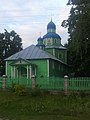
Nikolaikirche (built 1806)

Culture house

The Sinyaya in Krasnogorodsk


history
The place was founded in 1464 as the fortress Krasny Gorodez in the southwestern border area of the then Republic of Pskov . During the Russian-Polish wars , the place was under the rule of Poland-Lithuania from 1634 to 1667 . As a result, the fortress lost its military importance, and after various administrative changes, the place belonged to the Ujesd Opotschka of the Pskov governorate as Krasny from the end of the 18th century .
In 1927 Krasnogorodsk became the administrative seat of a newly created Rajons named after him. During the Second World War , Krasnogorodsk was occupied by the German Wehrmacht from the beginning of July 1941 to July 18, 1944 .
In 1967 the place received the status of an urban-type settlement. Until 1995 the official form of the name was Krasnogorodskoje.
Population development
| year | Residents |
|---|---|
| 1897 | 855 |
| 1939 | 1687 |
| 1959 | 2878 |
| 1970 | 4514 |
| 1979 | 5084 |
| 1989 | 5295 |
| 2002 | 4694 |
| 2010 | 3870 |
Note: census data
traffic
The regional road 58K-150 leads to Krasnogorodsk, which branches off the federal trunk road R23 Saint Petersburg - Pskov - Belarusian border (direction Vitebsk ) in the neighboring district of Opotschka, 25 km southeast . To the northwest the 58K-138 runs to the 58K-306 Pskow - Latvian border south of Pytalowo .
In Pytalowo, about 40 km north-west, on the Saint Petersburg - Pskow - Daugavpils (Latvia) route, part of the former Petersburg – Warsaw Railway, is the nearest train station.
Web links
Individual evidence
- ↑ a b Itogi Vserossijskoj perepisi naselenija 2010 goda. Tom 1. Čislennostʹ i razmeščenie naselenija (Results of the All-Russian Census 2010. Volume 1. Number and distribution of the population). Tables 5 , pp. 12-209; 11 , pp. 312–979 (download from the website of the Federal Service for State Statistics of the Russian Federation)
| Cities |
Dno R | Gdow R | Newel R | Novorschew R | Nowosokolniki R | Opotschka R | Ostrow R | Pechory R | Porchow R | Pskov S / R | Pustoschka R | Pytalowo R | Sebezh R | Velikiye Luki S / R |
|
| Urban-type settlements |
Beschanizy R | Dedowitschi R | Idriza | Krasnogorodsk R | Krasny Luck | Kunja R | Loknja R | Palkino R | Pljussa R | Pushkinsky Gory R | Saplyusye | Sosnovy Bor | Strugi Krasnye R | Uswjaty R |
