Attainville
| Attainville | ||
|---|---|---|
|
|
||
| region | Île-de-France | |
| Department | Val d'Oise | |
| Arrondissement | Sarcelles | |
| Canton | Fosses | |
| Community association | Plaine Vallée | |
| Coordinates | 49 ° 3 ' N , 2 ° 21' E | |
| height | 82-127 m | |
| surface | 7.16 km 2 | |
| Residents | 1,702 (January 1, 2017) | |
| Population density | 238 inhabitants / km 2 | |
| Post Code | 95570 | |
| INSEE code | 95028 | |
| Website | http://www.attainville.fr/ | |
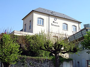
 Attainville Town Hall |
||
Attainville is a French commune with 1,702 inhabitants (as of January 1 2017) in the department of Val-d'Oise in the region of Ile-de-France . It belongs to the arrondissement of Sarcelles and is part of the canton of Fosses (until 2015: canton of Domont ). The inhabitants are called Attainvillois .
geography
Attainville is located about 22 kilometers north of Paris on the Forêt de Montmorency .
The neighboring municipalities of Attainville are Villaines-sous-Bois in the north, Villiers-le-Sec in the northeast, Le Mesnil-Aubry in the east, Ézanville in the south and southeast, Moisselles in the south and southwest, Baillet-en-France in the west and Montsoult and Maffliers in the northwest.
The national route 104 (the so-called Francilienne ) runs through the municipality .
Population development
| year | Residents |
|---|---|
| 1962 | 455 |
| 1968 | 503 |
| 1975 | 504 |
| 1982 | 589 |
| 1990 | 1375 |
| 1999 | 1732 |
| 2006 | 1808 |
| 2017 | 1702 |
Attractions
- Parish church of Saint-Martin , built between 1570 and 1576, Monument historique since 1912
literature
- Le Patrimoine des Communes du Val-d'Oise. Flohic Éditions, Volume 1, Paris 1999, ISBN 2-84234-056-6 , pp. 177-182.
Web links
Individual evidence
- ↑ INSEE: Population development of Attainville 1962-2012 ( page no longer available , search in web archives ) Info: The link was automatically marked as defective. Please check the link according to the instructions and then remove this notice.

