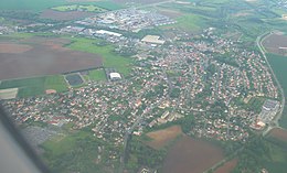
Le Thillay
| Le Thillay | ||
|---|---|---|

|
|
|
| region | Île-de-France | |
| Department | Val d'Oise | |
| Arrondissement | Sarcelles | |
| Canton | Villiers-le-Bel | |
| Community association | Roissy Pays de France | |
| Coordinates | 49 ° 0 ′ N , 2 ° 28 ′ E | |
| height | 52-104 m | |
| surface | 3.94 km 2 | |
| Residents | 4,557 (January 1, 2017) | |
| Population density | 1,157 inhabitants / km 2 | |
| Post Code | 95500 | |
| INSEE code | 95612 | |
| Website | http://www.mairie-le-thillay.fr/ | |
 Le Thillay Town Hall |
||
Le Thillay is a French village with 4557 inhabitants (as of January 1 2017) in the department of Val-d'Oise in the region of Ile-de-France ; it belongs to the arrondissement of Sarcelles and the canton of Villiers-le-Bel . The inhabitants are called Thillaysien (ne) s .
geography
The municipality is located about 20 kilometers northeast of Paris on the small river Croult . Le Thillay is surrounded by the neighboring communities of Goussainville in the north, Roissy-en-France in the northeast, Vaudherland in the east and Gonesse in the south and west.
The former Route nationale 17 (today's D317) runs through the municipality .
Population development
| year | 1962 | 1968 | 1975 | 1982 | 1990 | 1999 | 2006 | 2011 |
| Residents | 2,186 | 2,836 | 2,762 | 2,804 | 3,419 | 3,665 | 3,969 | 4.124 |
Attractions
- Saint-Denys church, mentioned around 1273, current building between 1543 and 1583, monument historique since 1965
- Lake of Thillay, artificial impoundment of the Croult
- Drap am Croult mill, destroyed by fire in 1902, rebuilt in neoclassical style
Personalities
- Magalie Vaé (* 1987), singer
literature
- Le Patrimoine des Communes du Val-d'Oise. Flohic Éditions, Volume 1, Paris 1999, ISBN 2-84234-056-6 , pp. 324-329.
Web links
Commons : Le Thillay - collection of images, videos and audio files


