
Pljussa (place)
| Urban-type settlement
Plyussa
Plussa
|
||||||||||||||||||||||||||||||
|
||||||||||||||||||||||||||||||
|
||||||||||||||||||||||||||||||
.svg)

Pljussa ( Russian Плю́сса ) is an urban-type settlement in the Pskov Oblast in Russia with 3450 inhabitants (as of October 14, 2010).
geography
The place is about 90 km as the crow flies northeast of the Pskov Oblast Administrative Center, a good 10 km from the border with Leningrad Oblast . It is located not far from the left bank of the eponymous right Narva tributary Pljussa .
Plyussa River is the administrative center of the Rajons Pljusski and seat and only town of the municipality (gorodskoje posselenije) Plyussa River.

Park on Lenin Street

shopping mall

Bus station
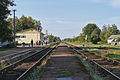
Pljussa railway station


history
Two small villages in the area of today's town were first mentioned in documents in 1498. In the middle of the 16th century, Pljussa was already described as a church village. During the Livonian War , the villages were destroyed in 1581/1582 or were not repopulated until 1629.
After the railway line Saint Petersburg - Warsaw passed by in 1859, the villages and the settlement at the railway station gradually grew together. The place belonged from the 18th century to the Ujesd Luga of the Saint Petersburg governorate .
On August 1, 1927, Pljussa became the administrative seat of a newly created Rajons named after him. During the Second World War , Strugi Krasnye was occupied by the German Wehrmacht from July 12, 1941 to February 18, 1944 . On March 5, 1971, the place received the status of an urban-type settlement.
Population development
| year | Residents |
|---|---|
| 1939 | 1978 |
| 1959 | 1964 |
| 1970 | 2378 |
| 1979 | 4101 |
| 1989 | 4317 |
| 2002 | 3856 |
| 2010 | 3450 |
Note: census data
traffic
Pljussa has a station at km 182 of the railway line St. Petersburg - Pskow - Daugavpils ( Latvia ) opened on this section in 1859 , which was built as part of the connection to Warsaw as one of the first long-distance lines of the Russian Empire .
The regional road 58K-089 runs through the settlement, which branches off almost 20 km east of the federal trunk road R23 Saint Petersburg - Pskow - Belarusian border (part of the European route 95 ) and continues through the northern part of the oblast to Gdow on Lake Peipus . In a south-westerly direction, the 58K-366 follows the railway line to the neighboring district center Strugi Krasnye and on again to the R23.
Web links
Individual evidence
- ↑ a b Itogi Vserossijskoj perepisi naselenija 2010 goda. Tom 1. Čislennostʹ i razmeščenie naselenija (Results of the All-Russian Census 2010. Volume 1. Number and distribution of the population). Tables 5 , pp. 12-209; 11 , pp. 312–979 (download from the website of the Federal Service for State Statistics of the Russian Federation)
| Cities |
Dno R | Gdow R | Newel R | Novorschew R | Nowosokolniki R | Opotschka R | Ostrow R | Pechory R | Porchow R | Pskov S / R | Pustoschka R | Pytalowo R | Sebezh R | Velikiye Luki S / R |
|
| Urban-type settlements |
Beschanizy R | Dedowitschi R | Idriza | Krasnogorodsk R | Krasny Luck | Kunja R | Loknja R | Palkino R | Pljussa R | Pushkinsky Gory R | Saplyusye | Sosnovy Bor | Strugi Krasnye R | Uswjaty R |
