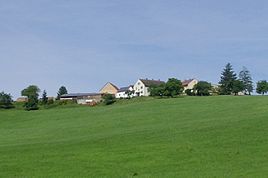
Kreuthof (Heidenheim)
|
Kreuthof
Heidenheim market
Coordinates: 48 ° 59 ′ 21 ″ N , 10 ° 43 ′ 31 ″ E
|
||
|---|---|---|
| Height : | 540 m above sea level NN | |
| Residents : | 11 (Jun 30, 2011) | |
| Postal code : | 91719 | |
| Area code : | 09833 | |
|
Location of Kreuthof in Bavaria |
||
|
Kreuthof
|
||
Kreuthof is a district of the Markt Heidenheim in the central Franconian district of Weißenburg-Gunzenhausen ( Bavaria ).
location
The wasteland is located in the Franconian Alb southwest of Heidenheim and west of State Road 2384 at a height west of the Rohrach .
Place name interpretation
"Kreuthof" should mean "courtyard on the piece of land made arable by Reuten (= clearing)".
history
The Kreuthof was created in the course of clearing measures by the nobles von Truhendingen as bailiffs over the Eichstatt forests west of the Rohrach around the middle of the 12th century. For the year 1391 it is handed down that the monastery Heidenheim “zw dem Gerewt” received taxes. "Grewt" is also listed in the monastery s book of 1400. A document from 1407 speaks of “Gerewt located near Hohentruhendingen ”. In 1437 Ulrich von Geilsheim gave his court to Gunzenhausen “called d. reutt bey Heydenheim laid “Hans Ottlein zu Heidenheim to fiefdom ; the noble knight von Geilsheim will have bought the farm from a previous owner. Utz Ottlein, son of Hans Ottlein, donated an "eternal cow" to his soul home in 1462 on the Kreuthof for the benefit of the pilgrimage to Mariabrunn ; The Kreutbauer could use milk and calves, but had to replace them in the event of perishing and pay an annual allowance of one pound of wax to the pilgrimage. In 1469 Ulrich von Geilsheim sold the farm to Wilhelm Leynleuter, Vogt in the town of Gunzenhausen; he sold it six years later to the chaplain Peter Hagen zu Mariabrunn, who later became the abbot of the Heidenheim monastery. After the secularization of the Heidenheim monastery, the “Gereuthof” (so 1535) had to provide riches to the margravial monastery administrator in Heidenheim and was subject to the high court under the margravial office of Hohentrüdingen, where taxes were also to be paid.
As a result of the Thirty Years' War , the "Kreüthoff" was deserted in 1650 ("everything burned away"). It was then rebuilt and is intact again in 1682 at the latest. According to a description from 1732, the kingdoms still had to be given to the margravial administrator in Heidenheim; the bailiwick and high Fraisch still held the margravial Oberamt Hohentrüdingen . This remained so until the end of the Holy Roman Empire . Ecclesiastically, the court was parish in the Protestant parish of Heidenheim.
The wasteland that became royal- Prussian with the margraviate of Ansbach in 1792 became royal-Bavarian as a result of the Reichsdeputation Hauptschluss in 1806. In forming the control districts 1808, the court came up with several other deserts and mills that the margravial monastery / stewardship Heidenheim became tributaries from the possession of the former convent Heidenheim, in the control district Heidenheim District Court Heidenheim . In 1810 the tax district was transformed into a rural community in Heidenheim; the Kreuthof came to the community of Hohentrüdingen. Through the municipal edict of 1818, Heidenheim became a municipality in the district court of the same name in the old extent of 1808, i.e. with the Kreuthof. In 1833 13.5 hectares of arable land, 3.8 hectares of meadows and 7 hectares of forest belonged to the Kreuthof .
On July 1, 1862, the district court of Heidenheim became part of the district office (later the district) of Gunzenhausen , which was transformed into the larger district of Weißenburg-Gunzenhausen during the regional reform in Bavaria in 1971/72.
In 1938, chipped parts of the outer facade of the synagogue in Heidenheim were used to fill in a ravine near the Kreuthof.
Population numbers
- 1818: 6 inhabitants
- 1824: 8 inhabitants, 1 building
- 1867: 13 inhabitants, 2 buildings
- 1950: 10 inhabitants, 2 buildings
- 1961: 12 residents, 2 residential buildings
- 1979: 12 inhabitants
- 1987: 12 inhabitants
- June 30, 2011: 11 residents
- June 27, 2016: 9 residents
literature
- Johann Caspar Bundschuh : Geographical Statistical-Topographical Lexicon of Franconia. 3rd volume, Ulm 1801, column 210.
- J. Heyberger and others: Topographical-statistical manual of the Kingdom of Bavaria with an alphabetical local dictionary. Munich 1867, column 1038.
- Hanns Hubert Hofmann: Historical Atlas of Bavaria, Franconia Series I, Issue 8: Gunzenhausen-Weissenburg. Munich 1960, pp. 135, 235.
- Official city directory for Bavaria 1964 with statistical information from the 1961 census. Munich 1964, column 785.
- Robert Schuh: Gunzenhausen. Former district of Gunzenhausen . Series of Historical Place Name Book of Bavaria. Middle Franconia, Volume 5: Gunzenhausen. Munich: Commission for bayer. Landesgeschichte 1979, in particular No. 153 (Kreuthof), p. 162f.
- 1250 years Heidenheim am Hahnenkamm. Heidenheim: Historical Association 2002.
- Martin Winter: From the Kreuthof near Heidenheim . In: Alt-Gunzenhausen 57 (2002), pp. 71-81.
Web links
Individual evidence
- ^ Schuh, p. 163; Winter, p. 71
- ↑ Winter, p. 73
- ↑ Winter, p. 75
- ↑ Martin Winter: The "eternal cow" from the Kreuthof. In: Alt-Gunzenhausen 57 (2002), p. 78f.
- ↑ Winter, p. 78
- ↑ a b Schuh, p. 162
- ↑ Bundschuh III, Col. 210
- ↑ Historical Atlas, p. 135
- ↑ a b c d Historical Atlas, p. 235
- ↑ 1250 years Heidenheim, p. 38
- ↑ Historical Atlas, p. 223
- ↑ 1250 years Heidenheim, p. 350
- ↑ Heyberger, Col. 1038
- ↑ Official Directory of places, Col. 785
- ↑ according to the Bavarian municipal parts file
- ^ Website of the Heidenheim market


