Kuchlmühle
|
Kuchlmühle ( Scattered Houses ) locality |
||
|---|---|---|
|
|
||
| Basic data | ||
| Pole. District , state | Perg (PE), Upper Austria | |
| Judicial district | Perg | |
| Pole. local community | Windhaag near Perg ( KG Altenburg ) | |
| Coordinates | 48 ° 15 '48 " N , 14 ° 38' 50" E | |
| height | 358 m above sea level A. | |
| Residents of the village | 8 (January 1, 2020) | |
| Building status | 8 (2001) | |
| Postcodes | 4320 perg | |
| Statistical identification | ||
| Locality code | 10289 | |
| Counting district / district | Windhaag near Perg (41126 000) | |
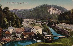
 Gasthof Kuchlmühle on the Naarn, around 1930 |
||
| Source: STAT : index of places ; BEV : GEONAM ; DORIS | ||
The Kuchlmühle or Kuchelmühle is a village with 10 inhabitants (as of January 1, 2001) in the Altenburg cadastral community of Windhaag near Perg in the Perg district in Upper Austria .
geography
location
The village consists of scattered houses and is located in the south-eastern part of the municipality on the Naarn . While the Gasthof Kuchlmühle is located directly on the Naarn in the Naar valley, the Edthof stands on a hill above the Naarn valley.
From a geological and geomorphological point of view, as well as from the point of view of the use of space, Lehenbrunn is partly part of the Upper Austrian spatial unit southern Mühlviertel peripheral locations and the Upper Austrian spatial unit Aist-Naarn-Kuppenland .
Limits
The Kuchlmühle belongs to the parish of Perg , as the political and parish boundaries do not coincide in this area.
The village of Kuchlmühle is delimited by the Naarn in the west from the village of Judenleiten of the Lebing cadastral community of Allerheiligen in the Mühlkreis , from the village of Lanzenberg of the Weinzierl cadastral community and from the former sub-forecourt of the Perg market in the city of Perg .
Karlingberg (Poschachersiedlung, Karlingberg, Forndorf and Pasching ), located in the municipalities of Perg (cadastral municipality of Pergkirchen ) and Windhaag bei Perg (cadastral municipality of Altenburg), and in the north, the village of Hochtor (cadastral municipality of Altenburg), reach the area in the southeast and east .
Bridges and roads
Originally the Naarnalstrasse ran directly past the Kuchlmühle and crossed the Naarn at this. A connecting road leads from the Naarn valley to Münzbacher Strasse out of the Naarn valley.
The Naarn valley and the Kuchlmühle were badly affected by the floods in 2002, after which the Naarnalstrasse had to be rebuilt from the Kuchlmühle towards Perg.
history
Until the beginning of the 19th century, the term Hadera was used to describe the village. Hans Kuchelmüllner was named as the owner of the Kuchlmühle in 1449, later the property belonged to the land register of the Windegg lordship (1664). In 1786 the property was located in the area of the tax municipality Windhaag. The Hametner family has been the owners since 1842. Above the mill there was a sawmill that was demolished in 1952. The mill can be visited as a small museum.
In the past, in the Kuchlmühle, besides grinding grain, there was also a bakery, in which gingerbread was also made at certain times.
At the beginning of the 1920s, the Kuchlmühle put emergency money into circulation.
Individual evidence
- ↑ Kuchlmühle ( Memento from December 21, 2015 in the Internet Archive ) (PDF; 97 kB)
- ↑ http://www.perg.at/beitraege/downloads/Geschnitze Lebkuchenformen.pdf (link not available)
- ↑ Johann Kodnar: Places with Notgeldausgaben - bank notes, bank notes, paper money Token from Austria. In: geldschein.at. Retrieved August 6, 2019 .

