Ländchen (Hessen)
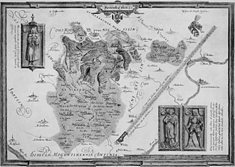
The Ländchen is a historical area east of Wiesbaden . It comprised the ten villages of Breckenheim , Delkenheim , Diedenbergen , Igstadt , Langenhain , Massenheim , Medenbach , Nordenstadt , Wallau and Wildsachsen , as well as the domain Mechtildshausen . As a Hessian exclave, it lay for three centuries between the Nassau area in the west and the Electoral Mainz area in the east.
The place Lorsbach is not counted as part of the Ländchen despite the territorial-historical cohesion. Some sources also exclude Langenhain.
Although it is often wrongly called that, the little country should not be confused with the blue country near Nastätze .
history

Until the 12th and 13th centuries , the later little country was part of the so-called Königssondergau , which stretched from the Kriftelbach in the east to the Walluf in the west. Since the end of the 12th century, the Lords of Eppstein held the Mechtildshausen district court in the east as a royal fiefdom; in the west the Counts of Nassau were enfeoffed with the high jurisdiction of the Reichshof Wiesbaden . After the Nassau-Eppstein feud , this ownership was confirmed in 1283; the area of the former Gaus was thus divided in two. With the division of the House of Eppstein into two lines, most of the eastern half fell to the Eppstein-Münzenberg line in 1433, with the exception of the villages of Wicker and Niederweilbach , which came to Eppstein-Königstein.
After various splits in the 15th century - for example, Bierstadt came to the Counts of Nassau in 1441, Hochheim to Kurmainz in 1478 - the little land was finally, together with other parts of the Eppstein lordship, in 1492 by Count Gottfried IX. (X.) from Eppstein-Münzenberg to Landgrave Wilhelm III. "The younger ones" from Hessen sold.
Landgrave Philip I “the Magnanimous” introduced the Reformation in the Landgraviate of Hesse in 1526 , and the area of the little land could be regarded as purely Protestant until the 20th century. In the census of December 1, 1910, of 7,818 inhabitants, only 248 were Catholics and 133 Jews . The territories bordering in the north, east and south, however, were predominantly Catholic.
In the Thirty Years' War the population fell to only 400 citizens in 1630. In 1821, 4805 inhabitants were counted.
In the course of the Marburg succession dispute , the area came to the Landgraviate of Hessen-Darmstadt in 1623 . In 1643 Wallau became an official place.
With the Reichsdeputationshauptschluss in 1803, the little country, like the adjacent Kurmainzian territories, fell to the Principality of Nassau-Usingen , which became part of the Duchy of Nassau in 1806 . When the duchy was redistributed into 28 offices on July 1, 1816 , Wallau was confirmed as the official place. In April 1817 the Wallau office was renamed the Hochheim office with small changes to the administrative district and Wallau lost the official seat.
In 1866 the Duchy of Nassau and with it the Wallauer Ländchen were annexed by Prussia . In 1879 the Ländchesbahn was opened, which today has a train station in Igstadt and the Auringen-Medenbach stop .
In the course of a territorial reform in the province of Hessen-Nassau in 1885, all the municipalities in the little country (except Langenhain) became part of the Wiesbaden district , which existed until 1928. After further administrative reforms and incorporations, Breckenheim, Delkenheim, Igstadt, Medenbach and Nordenstadt are now suburbs of Wiesbaden. Diedenbergen, Langenhain, Wallau and Wildsachsen are districts of Hofheim am Taunus ; Massenheim is a district of Hochheim am Main .
Web links
literature
- H. Diefenbach: The little country . In: Karl Jacobi (Hrsg.): Nassauisches Heimatbuch . Petmecky brothers, Wiesbaden 1913.
- Robert Geipel : Social structure and consciousness of unity as the basis of geographical structure (illustrated using the example of the “little country” between Frankfurt and Wiesbaden) . Kramer, Frankfurt am Main 1952 ( Rhein-Mainische Forschungen . Issue 38).
Individual evidence
- ^ Rudolf Dietz : The "Ländchen". In: Volk und Scholle. Association magazine of the Hessian Transport Association. Vol. 12, No. 4, 1934, p. 121.
- ↑ Marburg State Archives Kopiar 14, No. 5, Bl. 12-21v and Marburg State Archives Kopiar 21, No. 34 Bl. 153-176v. Archived copy ( memento of the original dated November 9, 2009 in the Internet Archive ) Info: The archive link was inserted automatically and has not yet been checked. Please check the original and archive link according to the instructions and then remove this notice.
- ↑ P. Wagner: The formation of the Duchy of Nassau and the Nassau Princely House . In: Karl Jacobi (Hrsg.): Nassauisches Heimatbuch . Petmecky brothers, Wiesbaden 1913.
- ↑ The area around the Wallau office was provisionally determined as follows: Wallau, Diedenbergen, Weilbach, Flörsheim, Hochheim, Wickert, Massenheim, Delkenheim, Nordenstadt, Igstadt, Breckenheim, Medenbach, Wildsachsen, Langenhain, Lorsbach and Epstein - as the previous scope of the Wallau office - then Marxheim from the Office Höchst. Google Books: Ordinance Gazette of the Duchy of Nassau, Volume 8, 1816, p. 109 Landesherrliches Edict of June 4, 1816
- ↑ On December 17, 1816, the Ducal-Naussau State Ministry decreed: Since it was also decided that on April 1 of the following year the seat of the previous Wallau office will be relocated to Hochheim and this district will be renamed the Hochheim Office should lead; so are in consideration of the easier resp. make connection with this official seat more difficult from 1st Jenner k. J. to the municipalities of Epstein and Lorsbach, previously part of the Wallau office, with the administrative district of Königstein, but the municipality of Eddersheim, which previously belonged to the Höchst office, was connected to the administrative district of Wallau (soon to be Hochheim). Google Books: Ordinance Gazette of the Duchy of Nassau, Volume 8, 1816, p. 333 Announcement of the Ducal Nassau State Ministry of December 17, 1816
Coordinates: 50 ° 5 ' N , 8 ° 22' E