
Vallagarina
| Vallagarina | ||
|---|---|---|
 The Vallagarina near Rovereto |
||
| location | Province of Trento , Province of Verona , Italy | |
| Waters | Etsch | |
| Mountains | Vicentine Pre-Alps , Lake Garda Mountains | |
| Geographical location | 45 ° 44 ′ N , 10 ° 57 ′ E | |
|
||
| Type | Trough valley | |
| rock | biogenic sedimentary rocks | |
| height | 100 to 2218 m slm | |
| length | 55 km | |

Vallagarina also Val Lagarina ( German Lagertal ) refers to the southern and at the same time lower valley section of the Adige Valley in the provinces of Trento and Verona in northern Italy .
geography
location
Vallagarina is the name of the section of the Adige Valley, which stretches south of Trento from the Murazzi narrow point between the towns of Aldeno on the orographic right side of the valley and Besenello on the orographic left side of the valley to the Veronese Klause on the edge of the northern Italian plain . The valley through which the Adige flows is about 55 km and is bordered on its east side by the Vicentine Prealps and in the west by the Lake Garda mountains. In the middle and lower section it runs practically parallel to Lake Garda to the west .
The Vallagarina has a number of side valleys, including the valley of the Rio Cavallo, the Val Terragnolo , the Vallarsa and the Val di Ronchi near Ala on the east side from north to south . On the west side, from north to south, there are the Valle di Cei, the Valle di Cameras near Mori and the valley of the Rio Sorna at the narrow point near Serravalle .
Administrative structure
Two thirds of the valley is located from its northern border to Borghetto, a fraction of the municipality of Avio , in the province of Trento. The lower section with the municipalities of Brentino Belluno and Dolcè belongs to the province of Verona, Veneto region . The municipalities in Trentino form the valley community of the same name, Vallagarina, with its administrative headquarters in Rovereto , which is also the largest town in all of Vallagarina.
traffic
The Brenner motorway A 22 , the Brennerbahn and the Brennerstaatstraße SS 12 run through the valley .
photos

Murazzi narrow point looking towards Trento, Besenello in the foreground, Aldeno in the background

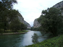
The Vallagarina with the narrow point at Serravalle south of Rovereto
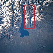
Satellite image showing the position of the valley
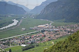
The lower Vallagarina near Avio on the border with the province of Verona

The southern end of the Vallagarina
Veronese Hermitage


literature
- Aldo Gorfer: Le valli del Trentino: guida geografico-storico-artistico-ambientale Volume 2 Trentino orientale . Manfrini, Calliano 1977.
- Aldo Gorfer: Terre Lagarine . Manfrini, Calliano 1977.
- Società degli Alpinisti Tridentini - Sezione del CAI - Commissione Sentieri: … per sentieri e luoghi. Sui monti del Trentino. 1 Prealpi Trentine Orientali. Monte Lessini, Caréga, Pasubio-Colsanto, Finònchio-Monte Maggio, Altopiani Vézzena-Lavarone, Cima Dodici-Ortigara, Vigolana, Marzòla. Euroedit, Trento, 2012, ISBN 978-88-86147-95-8 .
- Società degli Alpinisti Tridentini - Sezione del CAI - Commissione Sentieri: … per sentieri e luoghi. Sui monti del Trentino. 6 Prealpi Trentine Occidentali. Casale – Brento, Alpi Ledrensi, Paganella – Monte Gazza, Bondone – Tre Cime, Stivo, Monte Altissimo, Monte Baldo. Euroedit, Trient 2018, ISBN 978-88-941381-4-6 .
Web links
Individual evidence
- ↑ Aldo Gorfer: Terre Lagarine p. 7