Fraham
|
Fraham
|
||
|---|---|---|
| coat of arms | Austria map | |
|
|
||
| Basic data | ||
| Country: | Austria | |
| State : | Upper Austria | |
| Political District : | Eferding | |
| License plate : | EF | |
| Surface: | 16.94 km² | |
| Coordinates : | 48 ° 17 ' N , 14 ° 2' E | |
| Height : | 270 m above sea level A. | |
| Residents : | 2,391 (January 1, 2020) | |
| Population density : | 141 inhabitants per km² | |
| Postal code : | 4070 | |
| Area code : | 07272 | |
| Community code : | 4 05 04 | |
| Address of the municipal administration: |
Planbachstrasse 2 4070 Fraham |
|
| Website: | ||
| politics | ||
| Mayor : | Harald Schick ( SPÖ ) | |
|
Municipal Council : (2015) (25 members) |
||
| Location of Fraham in the Eferding district | ||
| Source: Municipal data from Statistics Austria | ||
Fraham is a municipality with 2391 inhabitants (as of January 1, 2020) in Upper Austria in the Eferding district in the Hausruckviertel . The community is located in the judicial district of Eferding .
geography
Fraham is located at an altitude of 270 m in the Hausruckviertel. The extension is 6.7 km from north to south and 6.2 km from west to east. The total area is 17 km². 1% of the area is forested, 13.6% of the area is used for agriculture.
Community structure
The municipality includes the following 15 localities (population in brackets as of January 1, 2020):
- Aumühle (57)
- Fraham (564)
- Guettlfeld (426)
- Hörstorf (53)
- Inn (101)
- Kappelding (32)
- Lahöfen (10)
- Oberhillinglah (23)
- Raffelding (260)
- Ranzing (5)
- Simbach (38)
- Steinberg (51)
- Stonewood (304)
- Trattworth (40)
- Unterhillinglah (427)
The community consists of the cadastral communities Fraham and Hörstorf.
history
The earliest written document is from 1262 and is "Vreihaym". The name goes back to Middle High German vri (free) and describes a parcel whose residents were not subject to tax.
Originally the eastern part of the Duchy of Bavaria , the place has belonged to the Duchy of Austria since the 12th century . Since 1490 it has been assigned to the Principality of Austria ob der Enns .
During the Napoleonic Wars , the place was occupied several times.
Since 1918 the place belongs to the federal state of Upper Austria. After the annexation of Austria to the German Reich on March 13, 1938, the place belonged to the Gau Oberdonau . After 1945 the restoration of Upper Austria took place.
coat of arms
Official description of the municipal coat of arms : square of green and gold; 1 and 4 a golden sheaf of grain , two and three a blue, left sloping bar, covered by a black mill wheel . The community colors are green-yellow-blue.
The grain stacks in the green fields emphasize the rural character of the community with 90% agricultural land. The mill wheels in the golden fields criss-crossed by a blue crossbar are a reminder of the importance of the grain mills on the Innbach at the time, which are among the oldest businesses in today's municipality.
traffic
Train and bus:
The railway lines Linzer Lokalbahn (LILO) (Linz - Eferding - Peuerbach / Neumarkt-Kallham ) and the Aschacher Bahn (Aschach - Eferding - Wels) run through the municipality .
The center of the village is accessed by the LILO stop “Fraham” (just outside) and the Eferding - Scharten - Wels bus line, the Steinholz district by the Aschacher Bahn (station: Kalköfen -Daxberg ) and the Aschach - Eferding - Wels bus line.
Other train stops in the municipality: Unterhillinglah (LILO) and Lahöfen (Aschacher Bahn).
Attractions
- Chapel: In Fraham there is a chapel with figures by the contemporary Eferdinger sculptor Agidius Gamsjäger .
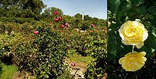
- Rosarium : The 'Rosarium Gruber' is located in the Trattwörth district. It shows an extensive collection of roses in a freely accessible garden on an area of 2000 m².
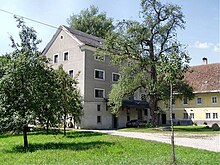
- Wiesmühle: The Wiesmühle is mentioned in a document as early as 1250. The four-storey mill house was built using the stones from Eferding's city gate, the Linzertor, which was demolished in 1828. Since 1925, hydropower has been used to generate electricity and a sawmill has been operated with it.
politics
Harald Schick ( SPÖ ) has been mayor of Fraham since 2012.
Population development
In 1991 the community had 1939 inhabitants according to the census, in 2001 then 1983 inhabitants.
Personalities
Sons and daughters of the church
- Ilse Oberländer (1938–2003), politician ( SPÖ )
- Anna Elisabeth Achatz (* 1950), politician ( FPÖ )
Individual evidence
- ↑ Statistics Austria: Population on January 1st, 2020 by locality (area status on January 1st, 2020) , ( CSV )
- ^ Ernst Schwarz: The place names of eastern Upper Austria (= Pr. German studies ). Kraus Verlag, Reichenberg, p. 113 .
- ^ Fraham: SP candidate Harald Schick new mayor. OÖN , June 3, 2012, accessed December 11, 2014 .
Web links
- 40504 - Fraham. Community data, Statistics Austria .
Further information about the Fraham community can be found on the geographic information system of the federal state of Upper Austria .


