Stroheim
|
Stroheim
|
||
|---|---|---|
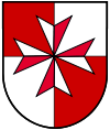
| coat of arms | Austria map | |
|
|
||
| Basic data | ||
| Country: | Austria | |
| State : | Upper Austria | |
| Political District : | Eferding | |
| License plate : | EF | |
| Surface: | 28.78 km² | |
| Coordinates : | 48 ° 20 ' N , 13 ° 57' E | |
| Height : | 489 m above sea level A. | |
| Residents : | 1,614 (January 1, 2020) | |
| Population density : | 56 inhabitants per km² | |
| Postal code : | 4074 | |
| Area code : | 07272 | |
| Community code : | 4 05 12 | |
| Address of the municipal administration: |
Stroheim 30 4074 Stroheim |
|
| Website: | ||
| politics | ||
| Mayor : | Rudolf Gammer ( ÖVP ) | |
|
Municipal Council : (2015) (19 members) |
||
| Location of Stroheim in the Eferding district | ||
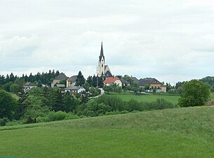
 View of Stroheim |
||
| Source: Municipal data from Statistics Austria | ||
Stroheim is a municipality with 1614 inhabitants (as of January 1, 2020) in Upper Austria in the Eferding district in the Hausruckviertel . The community is located in the judicial district of Eferding .
geography
Stroheim lies at 489 m above sea level. NN on a gneiss bar , which is 220 to 380 m above sea level. NN rises above the Eferdinger basin . The highest point, the Mayrhofberg, is 654 m above sea level. NN high and at the same time the highest point in the Eferding district . In the north, the terrain slopes steeply towards Aschach , which forms the municipal boundary for 2.7 km. There are no other waters worth mentioning due to the altitude.
The extension is 7.8 km from north to south and 9 km from west to east. The total area is 28.7 km². 28.6% of the area is forested , 63.4% of the area is used for agriculture .
Community structure
The municipality includes the following 22 localities (population in brackets as of January 1, 2020):
- Bergern (23)
- Birihub (37)
- Dunzing (1)
- Gmeinholz (30)
- Gotzenberg (10)
- Großstroheim (103)
- Gschnarret (19)
- Gstocket (12)
- Gugerling (11)
- Small straw (114)
- Knieparz ob der Leiten (40)
- Kobling (174)
- Mayrhof (95)
- Mitterstroheim (220)
- Reith (73)
- Schnellersdorf (65)
- Stallberg (68)
- Stroheim (306)
- Supply train (15)
- Windischdorf (93)
- Hesitating (78)
- Wölflhof (27)
The community consists of the cadastral communities Großstroheim and Mayrhof.
Neighboring municipalities (clockwise - the cardinal points in brackets):
St. Agatha (NW), Haibach ob der Donau (NE), Hartkirchen (O), Pupping (O), Hinzenbach (S), Prambachkirchen (W) and Waizenkirchen (W).
history
In 1110 the place was first mentioned as Strachen . Between 1272 and 1301, the Schaunberger documents contain the names Chunrad von Strafen and Ulrich von Strafener . Other earlier names of Stroheim are among others: Stoffen, Strahen, Strohham, Stroham and Strohheim .
Stroheim was a manor until 1848 . In that year the communities Mayrhof and Großstroheim were formed, which in 1876 were merged to form the community Stroheim.
religion
Around 1235, Count Johann I von Schaunberg had a Catholic parish church built. The building with the 52 m high tower is dedicated to John the Baptist . The count was a member of the Order of St. John and handed the church over as a subsidiary church to the Johannites of Mailberg , the later Maltese . The Maltese cross in today's municipal coat of arms is derived from this fact .
In 1784 Stroheim became its own parish . The parish church, which was Gothic in its origins , was later rebuilt several times, including a neo-Gothic interior; it received its present form in 1896/97.
In addition to the parish church, there is also the Landerlkapelle in the Geisberg district , built in 1901 and donated by the Pupping monastery . It is the destination of the annual Ascension processions and can also be used as a wedding church.
Today (2006) approximately 75% of the population are Catholics.
Culture and sights
- Parish Church Stroheim
- Maltese Commende
- Landerlkapelle: built in 1901
- Mayrhofberg : at the highest point of the community (654 m) there has been a brick observation tower since 1884.
politics
The municipal council consists of 19 members and has been composed of mandates from the following parties since the 2015 municipal council election: ÖVP 9, citizen list mea (together) 6, BZÖ + party-free citizens 2, SPÖ 2.
- mayor
- until 2009 Josef Rabeder (ÖVP)
- 2009–2015 Franz Breuer (ÖVP)
- since 2015 Rudolf Gammer (ÖVP)
coat of arms
Blazon : Of red and silver, square with a Maltese cross in alternating colors. The community colors are green and white. The notched ("eight-pointed") cross is the symbol of the Knights of St. John, later of the Order of Malta, founded in Jerusalem in 1113, which arose on the occasion of the Crusades to look after the pilgrims and defend the churches in the Holy Land. The Johanniter-Ordenskommende Stroheim was probably established around 1260 or already 1235 on the basis of a donation from the Lords of Schaunberg within their sphere of influence and the Commandery Mailberg / Lower Austria. handed over as a branch; In 1273 the Marienkirche above "Strahen" was first mentioned in writing in a deed of donation to the master Wulfing in Mailberg. After the establishment of the Stroheim parish in 1780 and 1784, respectively, the Malteser- Kommende renounced the patronage right in 1790 , which was finally transferred to the religious fund of the newly created diocese of Linz.
education
- Community kindergarten
- Elementary school
leisure
More than 10 clubs enrich the social life of Stroheim, in the areas of culture, sport, society, etc.
- two tennis courts
- Asphalt track
- Beach volleyball court
- public sports field
- Marked hiking trails
- in winter a 15 km long cross-country ski run
traffic
Because of its location on a mountain, there is no through traffic. The L 1217 Stroheimer Straße leads from Eferding via Stroheim into the Aschachtal near Waizenkirchen . There are also subordinate roads to other neighboring communities.
Personalities
- Johann Evangelist Aichinger (1805–1864), director of the institution for the deaf and dumb in Vienna
- Franz Hofer (1929–2020), politician
Web links
- Side of the community
- Map in the Digital Upper Austrian Room Information System ( DORIS )
- Further information about the municipality of Stroheim can be found on the geographic information system of the federal state of Upper Austria .
Individual evidence
- ↑ Statistics Austria: Population on January 1st, 2020 by locality (area status on January 1st, 2020) , ( CSV )
- ^ Johann Evangelist Aichinger. In: wien.gv.at. Retrieved July 26, 2020 .


