
Lech Quellenrunde
| Lech Quellenrunde | |
|---|---|
| Data | |
| location | Austria, Vorarlberg / Tyrol |
| Start / finish point |
Lech 47 ° 12 '36 " N , 10 ° 8' 34" E |
| Height difference | 995 m |
| The highest point | Gehrengrat |

The Lechquellenrunde is a six-stage mountain hiking tour in the Lechquellen Mountains in the Austrian state of Vorarlberg and a short stretch in Tyrol . It leads through Biberacher , Göppinger , Freiburger , Ravensburger and Stuttgarter Hütte , all huts of the German Alpine Club . The tour requires surefootedness and a head for heights . In the actual round it does not cross a mountain peak , its highest point is the Gehrengrat at 2439 m above sea level. A. The main European watershed will be crossed several times on the tour . A section of the Lechquellenrunde is a variant of the European long-distance hiking trail E4 .
Huts
The center and usually the starting point of the hiking tour is Lech . The recommended entry point, however, is Landsteg ( 1080 m above sea level ) - located on the Bregenzerwaldstraße between Schoppernau and Schröcken - where the hiking trail starts right at the bus stop. From there you can take the supply route to the Biberacher Hut ( 1846 m above sea level ) on the Schadona Pass in around two hours . Alternatively, you can hike from Schröcken ( 1269 m above sea level ) in four to five hours over the Alpe Felle and the Braunarlfürggele ( 2145 m above sea level ) to the hut. The Hochkünzelspitze ( 2397 m above sea level ) offers a summit variant .
From the Biberacher, the tour leads either in four and a half hours over Litealpe, lower and upper Alpschellaalpe and the karst Gamsboden or in five hours also over Litehütte, then over the Braunarlfürggele and Braunarlspitze ( 2649 m above sea level ) and the Theodor-Praßler- Path to the Göppinger hut ( 2245 m above sea level ). The local mountain of the Göppinger Hütte is the Hochlichtspitze ( 2600 m above sea level ).
There are two options for the route from the Göppinger to the Freiburger Hütte ( 1918 m above sea level ): once every five hours past the Eastern Johanneskopf , through the Johanneswanne to the Upper Johannesjoch and down to the Formarinalpe ( 1871 m above sea level ). Opposite the Alpe is a memorial for the resettlement of ibexes in the Eastern Alps. Then either south or north ( farm road ) around the Formarinsee to the Freiburger Hütte. The southern climb offers a beautiful view over the Formarinsee to the Rote Wand . The so-called bad weather variant also takes five hours from the Göppinger hut past the propeller monument over the upper and lower Älpele into the Formarintal to the Formarinalpe.
On the way from the Freiburger to the Ravensburger Hütte , the path climbs steeply to the southern flank of the Formaletsch . Then you cross the Stone Sea before the hiking trail climbs very steeply over the Gehrengrat to the Dalaaser Schütz . From there you descend to the Spullersee , which can be bypassed either via the north dam or the road from the Ravensburger Hütte south of the lake. The Ravensburger Hut is reached after about five hours. As a bad weather variant (three and a half hours) there is a descent on the road to the Formarintal, then via Tannlägeralpe and Spullertal to Spullersee. The Spullerschafberg ( 2679 m above sea level ) can be climbed from the hut .
The Stuttgarter Hütte is at 2310 m above sea level. A. the highest hut on the Lechquellen circuit. It can be reached in five and a half hours via the Stierlochjoch , Madlochjoch , Lake Zürs ( 2150 m above sea level ), descent to Zürs ( 1717 m above sea level ), Trittalpe ( 1946 m above sea level ) and Endress-Weg . Somewhat easier, but five and three quarters of an hour longer, is the path via Stierlochjoch , Zug and Lech, from where you can take the Rüfikopf cable car to the Rüfikopf to get to the Stuttgarter Hütte via the Rauhekopfscharte , the summit of which is the Krabachspitze ( 2522 m o. A. ) is.
From the Stuttgarter Hütte you can get back to the starting point in Lech either with the Rüfikopfbahn or in four hours over the Bocksbachsattel ( 2340 m above sea level ), Friedrich-Mayer-Weg and the Tällialpe .
gallery
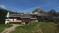
Biberacher hut

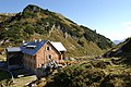
Goeppinger Hut
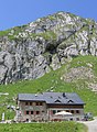
Freiburg hut
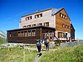
Ravensburger Hut
Stuttgart Hut


renewal


If the tour is to last seven instead of six days, the Ulmer Hut ( 2288 m above sea level ) is an option. To do this, climb from Zürs over the Flexenpass ( 1773 m above sea level ) to the hut, about seven hours of walking. From the Ulmer Hütte ascent to the Valfagehrjoch ( 2539 m above sea level ), from here either ascent to Valluga ( 2809 m above sea level ) and subsequent descent to the Robert-Bosch-Weg , the high-altitude path below the Roggspitze to the Stuttgarter Hütte or direct descent to the Robert-Bosch-Weg. The shorter variant leads partially insured over the trittscharte .
Current
In its From Hut to Hut series , the German Alpine Association in Munich published 25,000 copies of a brochure on the Lechquellenrunde in March 2012, which contains a map and directions including variants, all current data on the individual huts such as opening times and contact addresses.
Literature and maps
- Alpine club guide Lechtaler Alpen alpin , Bergverlag Rother, Munich 2002, ISBN 3-7633-1268-4
- Alpine club map (1: 25,000), sheet 3/2, Lechtal Alps - Arlberg area
Web links
- Lech Quellenrunde. (PDF, 6.45 MB) German Alpine Club, May 2015, accessed on August 22, 2019 .
- Homepage of the Lechquellenrunde. Lechquellenrunde, March 2016, accessed on January 3, 2017 .
Individual evidence
- ↑ http://www.lostaircraft.com/database.php?lang=de&e=8596&mode=viewentry# ( page no longer available , search in web archives ) Info: The link was automatically marked as defective. Please check the link according to the instructions and then remove this notice.
- ↑ Lech Quellenrunde. (PDF, 3.7MB) (No longer available online.) German Alpine Club, March 2012, archived from the original on May 22, 2012 ; Retrieved September 13, 2012 . Info: The archive link was inserted automatically and has not yet been checked. Please check the original and archive link according to the instructions and then remove this notice.