Leversbach
|
Leversbach
community Kreuzau
Coordinates: 50 ° 42 ′ 59 " N , 6 ° 27 ′ 58" E
|
|
|---|---|
| Height : | 247 (203-268) m above sea level NHN |
| Area : | 6.88 km² (with Boich) |
| Residents : | 548 (Jul 31, 2018) |
| Population density : | 80 inhabitants / km² |
| Incorporation : | 1st July 1969 |
| Postal code : | 52372 |
| Area code : | 02427 |
|
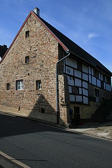
Gabled house in Leversbach
|
|
Leversbach is a district of the municipality of Kreuzau in the North Rhine-Westphalian district of Düren .
location
Leversbach is located on the north edge of the Eifel in the Rureifel in the North Eifel Nature Park . Neighboring towns are Rath , Üdingen , Boich and Obermaubach . From the upper village there is a good view of the Düren region and the Zülpicher Börde .
history
The place name research derives the name Leversbach from the Germanic tribe for "Bach on the burial mounds". Leversbach is an ancient settlement area. Archaeological finds suggest a Stone Age settlement.
In the years 1782 to 1787 seven footfalls were built in and around Leversbach. According to tradition, a child of the builder Degenhart Schroeder was seriously ill and he took the vow that if his child recovered from the disease, he would build seven footfalls for the glory of God. Two of these footfalls disappeared due to the destruction of World War II. At the time, the mayor suggested that the footfalls that had disappeared be rebuilt and so Leversbach has seven footfalls again.
In 1929, a fire brigade was founded in Leversbach, and with it a separate syringe house. After the Second World War there was no longer a fire brigade in Leversbach. The syringe house stood there unused for a long time and was left to decay. It was torn down in the early 1970s and the national park built a parking lot in its place.
On the site behind the former syringe house, the Leversbachers built their own sports field from 1983, which was inaugurated on September 25, 1988.
Reorganization
Leversbach and Boich used to belong to the Drove estate . After the Drove office was dissolved in 1932, the place became part of the Kreuzau office.
On July 1, 1969, the municipality Boich-Leversbach was incorporated into the municipality of Kreuzau with six other places.
As a result of the reorganization of the Aachen area ( Aachen law ), the municipalities of Obermaubach-Schlagstein and Untermaubach, the district of Langenbroich from the municipality of Hürtgenwald and the districts of Schneidhausen and Welk from the municipality of Lendersdorf were incorporated into the municipality of Kreuzau with effect from January 1, 1972 - the Niederau community came to Düren. Today's municipality of Kreuzau consists of the districts Bogheim, Boich, Drove, Kreuzau, Leversbach, Obermaubach with Schlagstein, Stockheim, Thum, Üdingen, Untermaubach with Bilstein and Winden with Bergheim and Langenbroich.
church
Leversbach always belonged to the mother parish of Drove. A chapel was not built until 1932 and was consecrated to Albertus Magnus . The chapel was one of the first church buildings designed by the well-known Professor Rudolf Schwarz . Under his direction, the further furnishing of the chapel was carried out by a "work group" of teachers and students from the Aachen School of Applied Arts : the monstrance by Anton Schickel , the eternal light, the six altar candlesticks and the baptismal crockery by Fritz Schwerdt and the small crucifix by Anton Schickel and Hein Minkenberg for the associated body. In July 1956 the rectorate was appointed an independent parish .
traffic
The district road 32 leads through the village from Kreuzau via Üdingen to Nideggen. Buses on the Dürener Kreisbahn take the AVV line 221 through the town.
Association
In the small town there is a leisure club, a music group , a sports club and a fan club for Borussia Mönchengladbach .
Others
At the end of 1967 a 30 m high concrete television mast was erected on the outskirts. As a result, television reception in the Rurtal was considerably improved.
Web links
- Photo walk through the site ( Memento from October 3, 2006 in the Internet Archive )
- Details on the furnishings of the Albert Magnus Chapel from 1932
Individual evidence
- ↑ http://www.kreuzau.de/ug/zadafa/index5.php
- ↑ Martin Bünermann: The communities of the first reorganization program in North Rhine-Westphalia . Deutscher Gemeindeverlag, Cologne 1970, p. 98 .
- ^ Federal Statistical Office (ed.): Historical municipality directory for the Federal Republic of Germany. Name, border and key number changes in municipalities, counties and administrative districts from May 27, 1970 to December 31, 1982 . W. Kohlhammer, Stuttgart / Mainz 1983, ISBN 3-17-003263-1 , p. 307 .


