Limpopo (river)
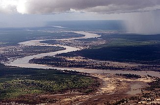
The Limpopo River forms the northern border of South Africa with Botswana and Zimbabwe and marginally in the near-shore area with Mozambique . It then crosses Mozambique over a distance of over 400 kilometers. It is 1,750 kilometers long and covers a catchment area of 415,000 km².
Origin and course
The Limpopo is the second longest river in Africa that drains into the Indian Ocean .
The source of the Limpopo is near Johannesburg (South Africa) on the Witwatersrand . The upper reaches of the Limpopo is called the Crocodile River , which absorbs the water of the Marico River at Oliphants Drift and is called Limpopo from there.
In the lower reaches of Mozambican territory there are fertile alluvial soils along its banks. The Limpopo flows into the Indian Ocean southwest of Xai-Xai (Mozambique), the administrative center of the Gaza Province . In the estuary, the land shows signs of salinization.
Climate and hydrometry
The mean annual discharge of the Limpopo is 7330 million cubic meters. Rainfall from South Africa contributes 66%, Zimbabwe 16%, Mozambique 12% and Botswana 6%. The average annual precipitation in the catchment area is 500 mm.
The Limpopo has a very pronounced seasonal drainage behavior. During the dry season, the mean discharge is 20 m³ / s, in the rainy season it is 590 m³ / s. The middle peaks are at 1600 m³ / s, but also, as for example in 2000, discharge rates of over 17,500 m³ / s were measured and there were floods in Mozambique (see Floods in Mozambique 2000 ). It reached a level of 13 m. Normally it fluctuates between 0.5 and 5 m.
The flow rate of the Limpopo was measured at Chókwè , about 100 km above the mouth in m³ / s (1952 to 1995).

Catchment area
The Limpopo catchment area is between 413,000 and 415,000 km² and extends over four countries. The largest part is in South Africa with 185,298 km² (45%), followed by Mozambique with 84,981 km² (21%), Botswana with 80,118 km² (19%) and Zimbabwe with 62,541 km² (15%).
The sub-catchment areas of the Limpopo are divided as follows (arranged from the source to the mouth):
| flow | Catchment area in [km²] | Percent of the area of the catchment area |
|---|---|---|
| Marico | 13.208 | 3.2 |
| Crocodile | 29,572 | 7.2 |
| Notwane | 18,053 | 4.4 |
| Matlabas | 3,448 | 0.8 |
| Mokolo | 7,616 | 1.8 |
| Bonwapitse | 9,904 | 2.4 |
| Mahalapswe | 3,385 | 0.8 |
| Lephalala | 4,868 | 1.2 |
| Lotsane | 9,748 | 2.4 |
| Mogalakwena | 20,248 | 4.9 |
| Motloutse | 19,053 | 4.6 |
| Shashe | 31,061 | 7.5 |
| Umzingwani | 15,695 | 3.8 |
| Sand river | 15,630 | 3.8 |
| Nzhelele | 3,436 | 0.8 |
| Boy | 8,140 | 2.0 |
| Luvuvhu | 4,826 | 1.2 |
| Mwenezi | 14,759 | 3.6 |
| Elephants (Lepelle) | 70,000 | 17.0 |
| Changane | 43,000 | 10.4 |
| Further | 67,288 | 15.3 |
| total | 412,938 | 100 |
National parks
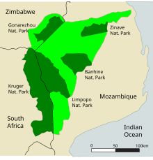
The Limpopo National Park is located in Mozambican territory between Limpopo and the border with South Africa . It is part of the cross-border Great Limpopo Transfrontier Park , which is currently under construction and for the most part will be located in the Limpopo catchment area.
Water management and intergovernmental contracts
The water of Limpopo is used intensively, especially in the South African provinces of Gauteng and Northwest and in the metropolitan area around Gaborone , the capital of Botswana. In 2004 around 14 million people lived in the catchment area.
In 2004 there were 44 dams in the Limpopo river system, 28 of them in South Africa, with a capacity of over twelve million cubic meters. The largest dam is the Loskop Dam on Lepelle (formerly Oliphants River) with a capacity of 348 million cubic meters. The Hartbeespoort Dam on the Crocodile River holds 195 million cubic meters.
There are two feed lines within the river system ( intra-basin transfers ), the North-South Water Carrier from Shashe to Notwane in Botswana and from Molatedi Dam in South Africa also to Notwane in Botswana. There are also four inter-basin transfers that bring water from other river systems to the South African part of Limpopo. The Komati Scheme supplies water from the Komati , the Usutu Scheme from the Usutu . From Lesotho , where large reservoirs were created as part of the Lesotho Highland Water Project , water flows from the Orange River system into Limpopo via the Grootdraai Emergency Augmentation Scheme , while a fourth system feeds water from the Vaal into the Crocodile River.
In 1986 the Limpopo Basin Permanent Technical Committee (LBPTC) was founded in Harare to advise the participating states on water use. It only became active in 1995, after the end of apartheid in South Africa. As a result, Mozambique feared overuse by the upper neighboring countries. The planned establishment of the Limpopo River Commission did not materialize. It was only in 2003 that an agreement was reached on the formation of the Limpopo Watercourse Commission , which was to succeed the LBPTC. The main task of the commission is to settle possible disputes. In addition to this agreement, there were and are numerous bilateral agreements on the use of Limpopo water.
River history
The Zambezi did not flow into the Mozambique Strait about 65 million years ago . It flowed parallel to the Cuando and Okavango and, like these, emptied into the Limpopo. The Zambezi used the river bed of the Shashe , and the Cuando that of the Motloutse .
The uplift of the Ovambo-Kalahari-Zimbabwe Fault (OKZ) created a new watershed that cut off the three rivers from the Limpopo and dammed the Makgadikgada Lake .
The soil patterns between the Limpopo and the Komati system indicate that in the past the Limpopo also flowed over the Maputo Basin .
See also
Web links
- German Development Institute: Africa's Great International Rivers and Lakes - Status and Experience in Transboundary Water Management in Africa based on Selected Examples (PDF pages 24–29) (PDF; 1.4 MB)
- Water management in the basin of the Limpopo on the website of the Food and Agricultural Organization (English)
Individual evidence
- ^ Joint Limpopo River Basin Study Scoping Phase - Final Report
- ^ J. Balek: Hydrology and water resources in tropical Africa. Elsevier, Amsterdam 2011, ISBN, p. 91. Excerpts from books.google.de
- ↑ Manfred Kuder: Moçambique. A geographical, social and economic study of the country . Scientific regional customers Volume 10, Darmstadt 1975, p. 276.
- ↑ a b German Development Institute: Africa's great international rivers and lakes - status and experience in cross-border water management in Africa based on selected examples (PDF page 25) (PDF; 1.4 MB)
- ^ Limpopo River Basin - A Proposal to Improve the Flood Forecasting and Early Warning System
- ^ Ministry for the coordination of environmental affairs - PAP / RAC
- ↑ a b FAO Natural Resources Management and Environment Department - Drought impact mitigation and prevention in the Limpopo River Basin. A situation analysis
- ↑ German Development Institute: Africa's Great International Rivers and Lakes - Status and experience in cross-border water management in Africa based on selected examples (PDF page 24) (PDF; 1.4 MB)
- ↑ a b German Development Institute: Africa's great international rivers and lakes - status and experience in cross-border water management in Africa based on selected examples (PDF page 26) (PDF; 1.4 MB)
- ↑ Water management in the Limpopo river basin on the website of the Food and Agricultural Organization (English), accessed on June 21, 2016
- ↑ German Development Institute: Africa's Great International Rivers and Lakes - Status and experience in cross-border water management in Africa based on selected examples (PDF page 28) (PDF; 1.4 MB)
- ↑ A proposed drainage evolution model for Central Africa — Did the Congo flow east?
- ↑ Gestão dos Recursos Hídricos em Mozambique: Gaza - Rio Limpopo


