
Loknja (Pskov)
| Urban-type settlement
Loknja
Локня
|
||||||||||||||||||||||||||||||
|
||||||||||||||||||||||||||||||
|
||||||||||||||||||||||||||||||
.svg)

Loknja ( Russian Ло́кня ) is an urban-type settlement in the Pskov Oblast in Russia with 3872 inhabitants (as of October 14, 2010).
geography
The place is a good 150 km as the crow flies southeast of the Pskov Oblast Administrative Center . It is located about four kilometers from the right bank of the eponymous left Lovat -Nebenflusses Loknya removed.
Loknja is the administrative center of Loknjanski Rajons and the seat and only locality of the municipality (gorodskoje posselenije) Loknja.
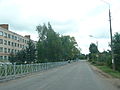
Street in Loknja
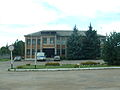
Police station in Loknja

Loknja Railway Station (before World War I )


history
The place was created in 1901 in connection with the construction of the railway line Saint Petersburg - Vitebsk , when a station named after the nearby river was built with a surrounding settlement. The village of Wlizy, which belongs to the place today, was first mentioned in a document as early as 1488.
On August 1, 1927, Loknja became the administrative seat of a newly created Rajons named after him. In 1941 the place received the status of an urban-type settlement. During the Second World War , Loknja was occupied by the German Wehrmacht from July 25, 1941 to February 26, 1944 .
Population development
| year | Residents |
|---|---|
| 1939 | 2194 |
| 1959 | 3421 |
| 1970 | 4277 |
| 1979 | 5262 |
| 1989 | 6061 |
| 2002 | 4898 |
| 2010 | 3872 |
Note: census data
traffic
Loknja has a station at kilometer 365 of the railway line St. Petersburg - Dno - Novosokolniki - Newel - Vitebsk ( Belarus ), which opened on this section in 1903 .
The regional road 58K-079 runs through the settlement, coming from the city of Velikye Luki , 60 km south, going east to the border of Novgorod Oblast , there as 49K-15 in the direction of Cholm - Staraya Russa - Shimsk . In a north-westerly direction, the 58K-019 branches off via Beschanizy and Novorschew to Pushkinskije Gory .
Web links
Individual evidence
- ↑ a b Itogi Vserossijskoj perepisi naselenija 2010 goda. Tom 1. Čislennostʹ i razmeščenie naselenija (Results of the All-Russian Census 2010. Volume 1. Number and distribution of the population). Tables 5 , pp. 12-209; 11 , pp. 312–979 (download from the website of the Federal Service for State Statistics of the Russian Federation)
| Cities |
Dno R | Gdow R | Newel R | Novorschew R | Nowosokolniki R | Opotschka R | Ostrow R | Pechory R | Porchow R | Pskov S / R | Pustoschka R | Pytalowo R | Sebezh R | Velikiye Luki S / R |
|
| Urban-type settlements |
Beschanizy R | Dedowitschi R | Idriza | Krasnogorodsk R | Krasny Luck | Kunja R | Loknja R | Palkino R | Pljussa R | Pushkinsky Gory R | Saplyusye | Sosnovy Bor | Strugi Krasnye R | Uswjaty R |
