
Louisenstrasse (Bad Homburg)

The Louis Street is the main shopping street of Bad Homburg and crosses the baroque Neustadt in a length of 1.5 kilometers.
General
Louisenstraße begins as an extension of the Ritter-von-Marx-Brücke and the Schulberg and leads to the southeast in the direction of the former Frankfurter Chaussee , the Landstraße to Frankfurt am Main , past the market square, the Kurhaus and the old train station, today's town hall. The full length of the street was from 1899 to 1962, and then until 1971 only the lower part of the streetcar ran through it.
Louisenstrasse and the quarters stretching on both sides mark the Neustadt , the extension of Homburg from the Baroque period that extends from the old town to the southeast. The originally Baroque development in the upper part of Louisenstrasse has been replaced by modern, row-forming residential and commercial buildings since the middle of the 19th century. The new building of a residential building set back from the street (No. 102) opposite the old station in 1878 resulted in a square-like extension. In 1902 the town received the area of the lower Louisenstrasse from the community of Gonzenheim , which offered the possibility of an extension to the southeast, while at about the same time further row-forming contemporary buildings were dispensed with in the area of the upper Louisenstrasse in favor of a development underlining the medieval town entrance. From 1902 to 1908, buildings in the style of late medieval office buildings , including the market arbors (no.13) from 1906/07 , were built from 1902 to 1908 according to plans by Louis Jacobi , who had also participated in the reconstruction of the palace and Saalburg .
More than 30 buildings are listed as individual monuments in Louisenstrasse. See the list of cultural monuments in Bad Homburg vor der Höhe here .
history
Development of the new town

From 1684, Landgrave Friedrich II began building the new town. The Neustadt was named after Friedrich's second wife, Luise Elisabeth von Kurland (1646–1690), Louisenstadt and the central street Louisenstrasse. In contrast to the winding, historically grown alleys of the old town, a system of right-angled streets was created in the new town according to a uniform plan. The main axes were the parallel streets Louisenstrasse and Dorotheenstrasse . When Friedrich II died in 1708, the Neustadt consisted of 53 houses, 38 of which were on Louisenstrasse. The planner of the new town is unknown. Presumably the building councilor Andrich drafted the plans. The first house on Louisenstrasse was built by Hofbäcker Johann Klußner in 1684. Since he ran out of money, master carpenter Dremmel, who had bought the house from him, completed the work in 1685. The residents of Neustadt were initially courtiers and craftsmen. Later Huguenots were increasingly added, which the Landgrave settled in Homburg.
There were four water supply fountains on Louisenstrasse: On the corner of Haingasse (formerly Brunnengasse), at the Gasthaus zum Löwen, at Waisenhausplatz and opposite the Gasthaus zum Adler. Landgrave Friedrich III. donated a new fountain on the corner of Haingasse. The Narcissus Fountain was a representative fountain that was shaped by a figure of Narcissus . Complete lists of residents for tax purposes have been preserved for the years 1738 to 1744. 103 houses are listed there.
Louisenstrasse as a traffic axis
_p17_EIN_THEIL_DER_LOUISENSTRASSE.jpg)

In 1899, the first tram line was opened in the city, which traveled the full length of Louisenstrasse to establish connections to Kirdorf, Dornholzhausen and, from 1900, also to Saalburg. Although residents protested against the growing noise just a few weeks after the start of operations, the single-track line was expanded into a double-track line so that local railway line 25 could also be used. This was opened on May 4, 1910 and led from its terminus on Marktplatz (corner of Haingasse) via Louisenstrasse to Frankfurt. The trams ran every 10 to 15 minutes on Louisenstrasse, which had become the city's main thoroughfare. In the city council meeting on May 24, 1910, the negative aspects were also discussed: the character of a “quiet spa and bathing town” would be lost and the hotel and retail trade would suffer. With regard to the hotel industry, this statement was correct: over the next 20 years, hotels disappeared (and tourism moved to quieter streets). However, the retail sector experienced an upswing. This was accompanied by the development of what is now a shopping street.
For years, the “Markt / Haingasse” tram and bus stop in particular was the hub of public transport. After the inner-city tram traffic in Louisenstrasse had declined sharply since the 1920s and local train line 25 between Markt and Altem Bahnhof was shut down from July 4, 1962, rail traffic also ended on December 19, 1971 on the remainder of the street; the tracks were subsequently dismantled.
On the other hand, since 1925, several bus routes have made their way through Louisenstrasse. Especially in the period after the Second World War, Federal Railways and Post omnibuses as well as private bus routes ran at frequent intervals towards the surrounding communities; especially the blue and red express buses to Frankfurt livened up the streetscape. Today bus routes only use the part of the street above Haingasse and in front of the Kurhaus and below the town hall. The stops there, however, allow the entire street to be easily connected to local public transport.
Since 1905, the construction of the bridge over the old town has also made it possible for through traffic to use Louisenstrasse. The increasing car traffic led to the construction of the bypass road, which was called Hindenburgring, in the 1930s. In addition, Bad Homburg received a connection to the newly built motorway . The relief of the Louisenstraße was canceled over the years by the steadily increasing motor traffic.
Louisenstrasse as a pedestrian zone

The conversion of Louisenstrasse into a pedestrian zone was proposed in the general traffic plan of 1969. The plan was hotly contested. Shifting traffic to Kaiser-Friedrich-Promenade would affect the cure, and Kisseleffstrasse could not accommodate the additional cars. Retailers worried that their customers could no longer reach them. Above all, however, the criticism presented by the Chamber of Industry and Commerce focused on the fact that parking garages should first be built to compensate for the spaces that are no longer available on Louisenstrasse before Louisenstrasse is declared a pedestrian zone.
Regardless of the protests, Louisenstrasse from Schloßplatz to Ferdinandstrasse was formally declared a pedestrian zone on June 20, 1973. However, the implementation took place over a longer period of time. The piece up to Haingasse was never implemented. The upper Luisenstrasse was first redesigned. The market square, which was renovated for 130,000 DM, was inaugurated on November 30, 1974. The pedestrian zone ended at the Kurhaus forecourt. On November 1, 1975, the section from Ludwigstrasse to Kisseleffstrasse was also rebuilt. In 1984 the Kurhaus forecourt was closed to traffic, but buses are still used. The lower area from Ferdinandstrasse to the Europa roundabout is still open to road traffic. In 1977 a fountain consisting of a tuff column over which the water flowed was set up by Christof Krause between Hertie and the town hall. Today the column is drained.
Louisenstrasse cinema location
After the first films were shown in smaller cinemas or inns (in Bad Homburg this was, for example, the Schauburg at Elisabethenstrasse 15 or the Schützenhof-Lichtspiele in Audenstrasse 2-4), large representative cinemas were built in prime locations in the 1920s . After the First World War, the Kur-Lichtspiele in Bad Homburg opened in the Kurtheater and in 1921 the Central-Lichtspiele opened at Louisenstraße 30 . The most important new opening was Adam Henrich's new cinema , Louisenstrasse 89 , which opened on December 14, 1918. During the inflationary period, all cinemas except for the Central-Lichtspiele and the Lichtspielhaus Louisenstraße 89 had to close. The Central-Lichtspiele were closed by the fire police in 1926.
The cinema business was now so good that Henrich expanded. In 1928 he opened the HELIPA (Henrichs-Lichtspiel-Palast) at Luisenstraße 26. Even if not as splendid as the Gloria-Palast , which Henrich opened in Gießen in 1935 , it was a lavishly furnished house. In 1933, however, Henrich had to close the old theater at Louisenstrasse 89 due to the global economic crisis .
On December 21, 1935, the Feldmaier couple opened a new cinema at Louisenstrasse 89: The Thalia . The Thalia was completely destroyed in the air raids on Thursday March 8, 1945 and was never rebuilt. The HELIPA remained undamaged and continued to exist after the war. In 1949 Inge Löwenstein was elected the first Miss Germany at HELIPA . As a result, several cinemas were opened. In 1954, the Rex opened at the old train station in Louisenstrasse as the city's fifth cinema. None of these cinemas survived the death of the 1960s. HELIPA and Rex were also closed. In 1983 there wasn't a single cinema in town. Since the cinema in the Taunus-Therme was closed, Bad Homburg no longer has a regular cinema.
Bank location Louisenstrasse

As the main shopping street, Louisenstraße was also the location for the Homburg banks. In 1855, the Homburger Bank started business at Louisenstrasse 66. In 1929 it was finally absorbed by Dresdner Bank , which continues its business at this address to this day. Since the merger with Commerzbank in 2009, two branches have been operated in downtown Homburg. The spatial merger of the two branches finally took place in September 2012 in the premises of the former Dresdner Bank at Louisenstrasse 66. The merger was celebrated on September 25, 2012 with a large open house . Lord Mayor Michael Korwisi visited the newly designed branch and wished the customers and employees all the best for the renovated branch. The branch offers space for over 70 employees on four floors. The bank gave up the location at Louisenstrasse 63. Previously, the Homburger Volksbank had its headquarters in Louisenstrasse 63 (the former Hotel Kaiserhof) . The successor institution, the Frankfurter Volksbank, now operates its Homburger branch at Louisenstrasse 80. The premises are currently being renovated. It is not yet known which companies will move into these premises.
The Kreissparkasse of the Obertaunuskreis had its seat in Louisenstrasse 88-90. After the Second World War, she built the new headquarters in 1953 on the site of the former Kurtheater on Louisenstrasse. In 1999 the head office was moved to the new district office on the outskirts. The Nassauische Sparkasse had been represented in Bad Homburg since 1865 (initially in Audenstrasse). In 1924, the Sparkasse moved the branch to Louisenstrasse 89 and is now represented at Louisenstrasse 53-57.
During the Empire, the banks Koch Lauteren & Co. and Homburger Bank- und Effekengeschäft (Louisenstrasse 78) still existed on Louisenstrasse .
The Disconto-Gesellschaft opened its branch in the Kurhaus before the First World War. The German bank as the successor institution has now its branch in the listed building Louisenstraße 52nd
The Santander Consumer Bank (previously SEB AG and Bank für Gemeinwirtschaft ) in the listed building Louisenstrasse 101 and the HypoVereinsbank opposite the town hall complete the banks on Louisenstrasse.
course
Beginning
50 ° 13 '43.3 " N , 8 ° 36' 45.1" E

The listed late baroque house Louisenstraße 1 was built directly on the castle wall in the new town. Louisenstrasse is here designated as a pedestrian zone ; the car traffic is forwarded over the kinking Haingasse. For decades, the famous Fischbach delicatessen was located in Louisenstrasse 5 .
The first part of Louisenstrasse is characterized by smaller retail stores. The first major department store is the former Woolworth branch . When the retail chain went bankrupt in 2009, the branch was closed. After two years of vacancy, it was announced in 2011 that a branch of Hennes & Mauritz would move in as a subsequent user.
The new market place and the redesign by Louis Jacobi
50 ° 13 ′ 41.7 " N , 8 ° 36 ′ 47" E

At the level of the opening in Löwengasse, Louisenstrasse widens into the market square. In the center of the market square is the lantern festival fountain, which is reminiscent of the traditional annual Bad Homburg lantern festival . The fountain was designed in 1979 by Harry Freder , the bronze casting was carried out by the traditional bell and art foundry Rincker in the Hessian sense .
The beginning of the 20th century meant a flood of urban changes for Bad Homburg. The construction of the Erlöserkirche led to the question of the redesign of the upper Dorotheenstrasse and Louisenstrasse. In 1904 Louis Jacobi presented the plan for a new market square (which Kaiser Wilhelm personally signed with the comment "very tastefully"). The dilapidated headquarters building as well as the adjoining butcher Reinhard's building had to be demolished to create a space. The Orangeriegasse was supposed to be widened by 6 meters by the demolition of the house of the evangelical pastor Karl Kranz and to create a broad connection to Dorotheenstraße and Erlöserkirche. In 1907/08 the market square was redesigned with market arbors according to these plans. Also in the period from 1890 to 1908 Jacobi created a number of houses along Louisenstrasse.
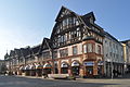
The square itself is framed by representative, listed buildings. First of all, the house at Louisenstrasse 13 on the north side of the square is striking. The “Renaissance building with wooden architecture” was built in 1907/08 based on a design by Louis Jacobi and was intended to represent “market arbors”. Outwardly, there is a historicizing illusionary architecture with exterior design in sandstone, plaster and half-timbered, the actual building, however, is built in concrete, iron shed and Rabitz. The building, which makes up the entire front of the square, is richly decorated with architectural decoration and sculpture. Among other things, you can find portrait heads of the architect Jacobi and market traders at the time. The sandstone work is by August Stenger .
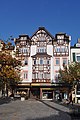
The houses Louisenstraße 15/17 form the top of the square. In 1926, architect Ludwig Lipp designed the classicist “New Market Balls”. It is a narrow, single-storey arcade building with a relatively flat gable roof connected to No. 19 by an archway. The arcades of the seven-axis concrete building were closed in 1947.
The south side of the square is dominated by the corner house Louisenstrasse 19. The original baroque part of the house dates from 1685/88. In 1855 it was converted into a retail store (Menges & Mulder) and modernized in 1883 (expansion of the mansard roof by Otto Voltz ). In 1909 the corner house was supplemented by Voltz / Jacobi with a rural-homely historicizing new Art Nouveau building. This elongated two-storey building forms the south side of the square.
Louisenstrasse 13

Louisenstrasse 15-17


Orphanage Square
50 ° 13 '38.3 " N , 8 ° 36' 54.9" E

Louisenstrasse continues as a shopping street in the direction of Waisenhausplatz. Louisenstrasse 26 stands out among the retail buildings. In 1903, Louis Jacobi built a three-storey residential and commercial building with an imposing two-zone front at the location of the “Goldene Rose” inn, which was founded in 1691. Similar to the marketplace development, it is a half-timbered building in the style of historicism with bay windows, gable and a wooden arcade.
The center of the Waisenhausplatz is the war memorial . It recalls the five Homburger soldiers in French German War of 1870 / 1871 was cast. It was designed by the builder Christian Holler and executed by the sculptor Jacob Mey . The ceremonial unveiling took place on May 10, 1875 .
In the southeast corner of the square stands out the listed building Waisenhausstrasse 1, the former orphanage that gave it its name. The construction of the orphanage was a lengthy process. In 1715, Landgrave Friedrich III. the property for the purpose of the orphanage construction. The construction was delayed for lack of money. The originally two-storey, baroque house with a mansard roof was built in 1721 in the shell and added in 1823. However, the money to set up the orphanage was still lacking, so the building was initially rented to a printing company. In 1730 the neighboring building was acquired by the Landgrave and the side wing was built on the new property. By 1742 the house was rebuilt "in the style of the palace pavilions " by Georg Moller . The orphanage was finally inaugurated on April 15, 1742. The building was used as an orphanage from 1742 until after 1945.
On the Louisenstrasse side, the building Louisenstrasse 48 catches the eye. The residential and commercial building, built in 1846, was rebuilt in 1904 according to Louis Jacobi's plan, adding storeys and historicizing the facade. It is a four-story, eaves-standing house with a five-axis facade.
Louisenstrasse 48

Kurhausplatz
50 ° 13 '36.5 " N , 8 ° 37' 0.8" E

50 ° 13 '37 .7 " N , 8 ° 37' 2.4" E

In 1843 the Bad Homburg Kurhaus opened on Louisenstrasse. Casino and spa operations lead to the creation of a large number of hotels and tourist accommodation. A number of hotels are also being built on Louisenstrasse.
The Schwedenpfad branches off at the three-storey classicist corner house Louisenstraße 52 (today the headquarters of Deutsche Bank, formerly the “Zum Adler” inn) and Louisenstraße widens to the north to Kurhausplatz. The center of the square is formed by a fountain. Opposite the Kurhaus is the listed building of the Imperial Post , built in 1893 . In 1999, the plans to demolish the Dorotheenparkhaus and the redesign of the area between Waisenhausstrasse and Thomasstrasse failed through a referendum. It is the area between Dorotheenstrasse and Louisenstrasse at the level of the Kurhaus. Ludwigstrasse / Thomasstrasse limits the Kurhaus forecourt to the east.

Imperial Mail

Between the spa and town hall
50 ° 13 '30.9 " N , 8 ° 37' 12.8" E


The large retail stores are concentrated on the next 300 meters. First, however, there are listed houses with the numbers 79 to 83 on the right-hand side. On the other side of the street, at the corner of Kisseleffstrasse 6 and Louisenstrasse 80/82, there is the Louisen-Arkaden shopping center . The building Louisenstrasse 80/82 was originally the Hotel Augusta and was transferred to the Gustav Weigand Foundation in 1916 and converted into a hospital. Until 1977 it served as a health clinic for war invalids. Today the Louisen-Arkaden is home to a number of specialty shops.
All houses on the left side of the section between Kisseleffstrasse and Ferdinandstrasse are listed as historical monuments. The old district office is particularly important. The building, built in 1854, was converted into the Louisen-Center shopping center in 2010 . In particular, the demolition and rebuilding of the listed facade was controversial.
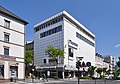
Karstadt is on the other side of the street and contrasts strongly with the modern glass facade . From 1966 to 1968 the department store was built as Hertie . The department store opened on March 1, 1968, had the first multi-storey car park in the Obertaunus district . The department store divided opinions: While the new building was seen as a crowd puller and evidence of Bad Homburg's central function, it was criticized (for example in the Prognos report) as being “scale-less construction”. Another large retail building is Möbel Meiss on the corner of Ferdinandstrasse.
Meiss furniture

The railway stations
50 ° 13 '26.6 " N , 8 ° 37' 20.3" E
The Homburger Bahn , opened in 1860, changed the character of Louisenstraße decisively, which now quickly developed in the direction of the terminus station , which was built on the site of today's town hall. Louisenstrasse had become the representative entrance to the city. Significant hotels on Louisenstrasse were:
- Grand Hotel (formerly Vier Jahreszeiten) at Louisenstrasse 89
- Hotel Viktoria in Louisenstrasse 91/93
- Railway hotel in Louisenstrasse 113
- Hotel Braunschweig at Louisenstrasse 80/82
- Englischer Hof in Louisenstrasse 98
A further terminus station was also built on the lower Louisenstrasse in 1895, the terminus of the Usinger Bahn, which was also used by the Friedberger line from 1901. The small station building was almost 100 meters from Louisenstrasse, at today's Philipp-Reis-Strasse; the tracks were parallel to today's motorway feeder.
The construction of the new train station , which opened in 1907 and replaced the two earlier stations, hardly diminished the importance of Louisenstrasse. It was designed as a central train station and thus potentially suitable for moving traffic flows and passers-by away from Louisenstrasse to the new location 300 meters away. But this did not happen. Louisenstrasse retained its role as the most important traffic axis thanks to the tram and, above all, the opening of the local line 25 to Frankfurt.
Lower Louisenstrasse
50 ° 13 '26.7 " N , 8 ° 37' 20.4" E
The pedestrian zone ends at the intersection with Ferdinandstrasse.
The dominant building at the intersection is the new town hall. The town hall is located on the site of the old train station and also has shopping facilities. The continuation of Louisenstrasse shows a completely different picture. There is hardly any retail trade here. Instead, residential buildings (many of them listed) characterize the street.
The Villa Hammelmann (Louisenstrasse 120) is outstanding . Located in a park-like garden, the villa, which was built according to a design by Jacobi in 1892/93, stands out above all for its hooded polygonal tower on the corner of the house.
Louisenstrasse ends at the Europakreisel. The Europakreisel connects Louisenstrasse, Am Hohlebrunnen, Lange Meile, Friesenstrasse and Frankfurter Landstrasse (the continuation of Louisenstrasse through Gonzenheim).
The last house, Louisenstraße 163, is a listed building, as are the other houses on the roundabout: At Hohlebrunnen 2 and Frankfurter Landstraße 2. Next to it is the Bad Homburg public utility building on the roundabout. A number of historical landmarks have been placed in front of the Stadtwerke building.
50 ° 13 '17.1 " N , 8 ° 37' 42.7" E
Action group trade, craft, trade
In 1973 the action group Louisenstraße was founded as a trade association . On July 17, 1978, the name was changed to Werbegemeinschaft Bad Homburg vor der Höhe and, on April 18, 1983, to Aktiongemeinschaft Handel, Handwerk, Gewerbe . The action group promotes the commercial and trading location Bad Homburg and especially Louisenstrasse and is the organizer of a number of events on Louisenstrasse.
Regular events
In addition to the general festivals of the city of Bad Homburg, such as the Lantern Festival , which also takes place on Louisenstrasse, there are regular events on Louisenstrasse.
- Bad Homburg Wine Festival
- Thanksgiving Market
- Bad Homburg Christmas City
literature
- Monument topography Bad Homburg, Wiesbaden 2001
- Angelika Baeumerth: Die Louisenstraße , in: From the city archive 1999/2000 (2001), pp. 53–85
- Angelika Baeumerth: The Louisenstrasse in Bad Homburg , in: Ingrid Berg: Heimat Hochtaunus . Kramer, Frankfurt 1988, ISBN 3-7829-0375-7 , pp. 204-208.
- Friedrich Lotz: History of the city of Bad Homburg before the height / ed. from the city council of Bad Homburg vor der Höhe; Part 2. The Landgrave Time, 1972, ISBN 3-7829-0133-9
- Heinz Grosche: History of the city of Bad Homburg before the height / ed. from the city council of Bad Homburg vor der Höhe; Part 3. The Imperial Era, 1986, ISBN 3-7829-0334-X
- Heinz Grosche: History of the city of Bad Homburg before the height / ed. from the city council of Bad Homburg vor der Höhe; Part 4. Three difficult decades: 1918–1948, 1993, ISBN 3-7829-0436-2
- Barbara Dölemeyer u. a .: History of the city of Bad Homburg vor der Höhe / ed. from the magistrate d. City of Bad Homburg in front of d. Height; Part: 5. Awakening - Tradition - Growth: 1948–1990, 2007, ISBN 978-3-7973-1048-4
- Walter Söhnlein: Bad Homburg vdHöhe - 150 years of public transport and urban structure , Landsberg-Pürgen 1978
Web links
- State Office for Monument Preservation Hessen (Ed.): Untere Louisenstrasse In: DenkXweb, online edition of cultural monuments in Hessen
- Louisenstrasse . Bad Homburg digital building book. In: Landesgeschichtliches Informationssystem Hessen (LAGIS).
Individual evidence
- ^ Friedrich Lotz: History of the city of Bad Homburg in front of the height, part 2, pp. 103-105; A list of all these houses and their owners or builders can also be found here
- ^ Friedrich Lotz: History of the city of Bad Homburg before the height, part 2, p. 89
- ^ Friedrich Lotz: History of the city of Bad Homburg in front of the height, part 2, pp. 94–94
- ^ Friedrich Lotz: History of the city of Bad Homburg in front of the height, part 2, p. 127
- ^ Friedrich Lotz: History of the city of Bad Homburg in front of the height, part 2, pp. 137-140; A list of all these houses and their owners can also be found here
- ^ Heinz Grosche: History of the city of Bad Homburg in front of the height, part 4, pp. 443-444
- ↑ Barbara Dölemeyer u. a .: History of the city of Bad Homburg vor der Höhe. Part 5, pp. 124-127
- ↑ Heinz Grosche: History of the city of Bad Homburg in front of the height. Part 4, p. 43 ff.
- ^ Heinz Grosche: History of the city of Bad Homburg in front of the height, Part 4, pp. 335–336
- ^ Heinz Grosche: History of the city of Bad Homburg in front of the height, part 4, pp. 459-460
- ^ Heinz Grosche: History of the city of Bad Homburg in front of the height, Part 3, pp. 436–441
- ^ Friedrich Lotz: History of the city of Bad Homburg before the height, part 2, pp. 125–126
- ↑ Barbara Dölemeyer u. a .: History of the city of Bad Homburg vor der Höhe , part 5, pp. 127–128.
- ^ Heinz Grosche: History of the city of Bad Homburg in front of the height, part 3, pp. 418-425
- ↑ Barbara Dölemeyer u. a .: History of the city of Bad Homburg vor der Höhe, part 5, pp. 262–263
Coordinates: 50 ° 13 ′ 29.2 " N , 8 ° 37 ′ 14.6" E