Lug (Bronkow)
|
Lug
Bronkow parish
Coordinates: 51 ° 37 ′ 51 ″ N , 13 ° 55 ′ 45 ″ E
|
|
|---|---|
| Height : | 120 m above sea level NHN |
| Area : | 5.56 km² |
| Residents : | 145 (December 31, 2016) |
| Population density : | 26 inhabitants / km² |
| Incorporation : | October 26, 2003 |
| Postal code : | 03205 |
| Area code : | 035329 |
Lug ( Lower Sorbian Ług ) is a place in the Oberspreewald-Lausitz district in southern Brandenburg . He belongs to the municipality of Bronkow in Altdöbern .
location
Lug is located in Niederlausitz . To the north of the village lies Lipten, which like Lug belongs to the Bronkow municipality. In the east, Lug borders on Rettchensdorf and the Großräschen district of Woschkow . The Großräschener districts of Freienhufen and Wormlage are to the south . In the west follow the places Dollenchen and Göllnitz , which already belong to the district of Elbe-Elster .
At Lug, the Kleine Elster arises from the Lug Canal and the Mühlengraben .
history
Local history
Lug was first mentioned as Lugk in 1460 . The name is derived from the Lower Sorbian word for a swampy valley ( meadow or grass swamp ). From 1460 to 1527 the Köckritze owned the place. Kaspar von Köckritz is enfeoffed with the Seese manor in 1527 . Lug was part of the feud given to him by the Crown of Bohemia . In 1541 the place was called Luck and was owned by the von Schulenburg family . Like the whole of Lower Lusatia, the place belonged to the Kingdom of Bohemia until the Thirty Years War and then came to the Electorate of Saxony . In 1653 and 1659 the von Klitzing family was named as the owner. The parish was Lug to Lipten, which was a daughter church of Göllnitz. After the Congress of Vienna , Lug came to the Kingdom of Prussia . Lug belonged to the Prussian district of Calau . The Lug Canal, built in 1848, made it possible to use the peat area of the same name south of the village. In 1864 there was a sheep farm, a tavern and two windmills in the village. In 1900 another fire broke out in Lug, in which three farmsteads, a stable and a belt workers' house were destroyed. Heinrich Graf von Witzleben acquired the estate in 1910 . From 1916 to 1920 a separation was carried out in Lug , during which the small field plots were converted into larger fields. Lug was connected to the electricity network in 1928. The volunteer fire brigade was founded on July 26, 1929 . Since 1937 the place Lug has been written without k.
After the Second World War, Lug stayed in the Calau district, which was newly founded in 1952 . On October 26, 2003, Lug merged with the towns of Lipten and Bronkow to form the municipality of Bronkow.
Population development
| Population development in Lug from 1875 to 2002 | |||||||||||||
|---|---|---|---|---|---|---|---|---|---|---|---|---|---|
| year | Residents | year | Residents | year | Residents | year | Residents | year | Residents | year | Residents | year | Residents |
| 1875 | 277 | 1933 | 274 | 1964 | 231 | 1989 | 148 | 1993 | 167 | 1997 | 164 | 2001 | 168 |
| 1890 | 205 | 1939 | 281 | 1971 | 221 | 1990 | 150 | 1994 | 170 | 1998 | 166 | 2002 | 165 |
| 1910 | 261 | 1946 | 345 | 1981 | 176 | 1991 | 159 | 1995 | 164 | 1999 | 182 | ||
| 1925 | 248 | 1950 | 323 | 1985 | 164 | 1992 | 164 | 1996 | 169 | 2000 | 167 | ||
Culture and sights
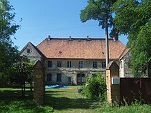
There is a listed manor house in Lug.
Economy and Infrastructure
The federal motorway 13 runs east of the village .
Individual evidence
- ↑ Community and district directory of the state of Brandenburg. Land surveying and geographic base information Brandenburg (LGB), accessed on June 17, 2020.
- ^ Entry "Ług" in the Lower Sorbian place name database on dolnoserbski.de
- ↑ Statistics of the German Reich, Volume 450: Official municipality directory for the German Reich, Part I, Berlin 1939; Page 249
- ↑ Brandenburg Statistics (PDF)
literature
- Ernst Eichler : The place names of Niederlausitz . VEB Domowina-Verlag, Bautzen 1975.

