Mühlhausen (twist valley)
|
Mulhouse
municipality Twistetal
Coordinates: 51 ° 20 ′ 1 ″ N , 8 ° 54 ′ 29 ″ E
|
|
|---|---|
| Height : | 295 (282-307) m above sea level NHN |
| Area : | 10.52 km² |
| Residents : | 636 |
| Population density : | 60 inhabitants / km² |
| Incorporation : | December 31, 1971 |
| Postal code : | 34477 |
| Area code : | 05695 |
|
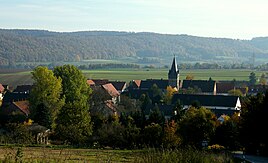
View of Mühlhausen
|
|
Mühlhausen is one of a total of seven districts in the municipality of Twistingal in the Waldeck-Frankenberg district in northern Hesse .
Geographical location
State road 3297 runs through the village .
history
860 the place is mentioned as Mulinghusen in Corveyian possession . In 1731 there was an iron hammer and a steelworks - this region still bears the name “Mühlhäuser Hammer” today. On the "Mörderkopf", around four kilometers from the village, there are remains of a ring-shaped moat and the remains of the foundations of a high medieval castle, which was probably built in the 11th or 12th century.
At 31 December 1971 was Mulhouse in the course of administrative reform in Hesse with five additional locations for new large village Twistetal together .
Population development
Source: Historical local dictionary
| • 1541: | 35 houses |
| • 1620: | 47 houses |
| • 1650: | 23 houses |
| • 1738: | 57 houses |
| • 1770: | 82 houses |
| Mühlhausen: Population from 1770 to 2015 | ||||
|---|---|---|---|---|
| year | Residents | |||
| 1770 | 429 | |||
| 1834 | 546 | |||
| 1840 | 596 | |||
| 1846 | 569 | |||
| 1852 | 631 | |||
| 1858 | 595 | |||
| 1864 | 562 | |||
| 1871 | 538 | |||
| 1875 | 509 | |||
| 1885 | 527 | |||
| 1895 | 537 | |||
| 1905 | 544 | |||
| 1910 | 529 | |||
| 1925 | 555 | |||
| 1939 | 627 | |||
| 1946 | 801 | |||
| 1950 | 770 | |||
| 1956 | 656 | |||
| 1961 | 662 | |||
| 1967 | 691 | |||
| 2008 | 636 | |||
| 2010 | 625 | |||
| 2015 | 636 | |||
| Data source: Historical municipality register for Hesse: The population of the municipalities from 1834 to 1967. Wiesbaden: Hessisches Statistisches Landesamt, 1968. Further sources:; Twistan valley community | ||||
Religious affiliation
Source: Historical local dictionary
| • 1885: | 534 Protestant (= 99.44%), 3 Catholic (= 0.56%) residents |
| • 1961: | 629 Protestant (= 95.02%), 26 Catholic (= 3.93%) residents |
church
The Mühlhauser church dates from the 12th century and is the Holy St. Georg consecrated. A donation made it the property of Boke Monastery , which was moved to Flechtdorf in 1104 and thus became Flechtdorf Monastery . It is located in the middle of the village on a slightly elevated former churchyard (cemetery). The design is very similar to the church in Berndorf . Originally it was a Romanesque arched pillar basilica with a square choir and west tower. The side aisles were demolished in 1787. At around the same time, the probably much older tower was given a half-timbered tower and an eight-sided pointed helmet with four little gables.
The former arcades in the nave were walled up to the central nave, this can still be seen on the outside of the brickwork. The western arcade on the north side serves as the entrance. In 1844 a half-timbered vestibule was added. The arched windows in the nave and in the choir were enlarged in the baroque period .
In 2010 the renovation of the St. Georg Church was completed.
Regular events
- Free shooting takes place every seven years .
Personalities
- Johannes Friedrich Emde (1806–1882), member of the state parliament in Waldeck, 1854–1872 mayor of Mühlhausen
- Eduard Emde (1841–1929), member of the state parliament in Waldeck, 1878 to 1888 mayor of Mühlhausen
literature
- Churches in the parish of the Twiste
- Misschalk / Kulik: Land an der Eder and Diemel , Korbach 1983, ISBN 3870770414
- Literature about Mühlhausen in the Hessian Bibliography
Web links
- District Mühlhausen. In: Internet presence of the municipality of Twist valley.
- Mühlhausen, Waldeck-Frankenberg district. Historical local dictionary for Hessen. In: Landesgeschichtliches Informationssystem Hessen (LAGIS).
Individual evidence
- ↑ a b c d Mühlhausen, Waldeck-Frankenberg district. Historical local dictionary for Hessen. (As of October 16, 2018). In: Landesgeschichtliches Informationssystem Hessen (LAGIS).
- ↑ Mühlhausen district. In: Internet presence of the municipality of Twist valley. Accessed June 2016.
- ^ Federal Statistical Office (ed.): Historical municipality directory for the Federal Republic of Germany. Name, border and key number changes in municipalities, counties and administrative districts from May 27, 1970 to December 31, 1982 . W. Kohlhammer, Stuttgart / Mainz 1983, ISBN 3-17-003263-1 , p. 409 .


