District Mache
| District Mache | |
|---|---|
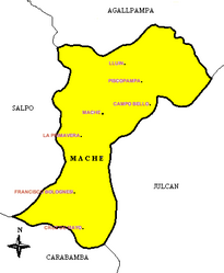
 District map |
|
| Basic data | |
| Country | Peru |
| region | La Libertad |
| province | Otuzco |
| Seat | Make |
| surface | 37.3 km² |
| Residents | 2881 (2017) |
| density | 77 inhabitants per km² |
| founding | March 7, 1964 |
| ISO 3166-2 | PE-LAL |
| politics | |
| Alcalde District | Edinson Ferry Escobedo Espinola (2019-2022) |
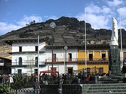
| Plaza de Armas in progress | |
Coordinates: 8 ° 1 ′ 49 ″ S , 78 ° 32 ′ 6 ″ W
The district of Mache is located in the province of Otuzco in the La Libertad region in western Peru . The district was established on March 7, 1964. It has an area of 37.3 km². The 2017 census counted 2881 inhabitants. In 1993 the population was 3343, in 2007 it was 3195. The district administration is located in the approximately 3300 m high village of Mache with 739 inhabitants (as of 2017). Mache is 14 km south-southeast of the provincial capital Otuzco .
Geographical location
The Mache district is located in the south of the Otuzco province. The Río Moche flows west along the northeastern district boundary. The area is located in its catchment area .
The district Make bordered on the west by the district Salpo , on the north by the district Agallpampa , on the east by the district Julcan ( province Julcan ) and in the south by the district Carabamba (also in the province Julcan).
Web links
- Peru: Region La Libertad (provinces and districts) at www.citypopulation.de
- INEI Perú
