Mahlberg (mountain)
| Mahlberg | ||
|---|---|---|
|
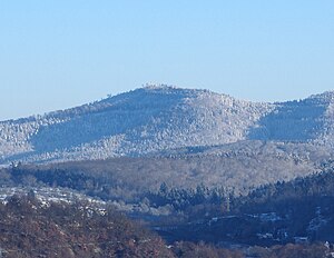
The Mahlberg seen from Gernsbach on a winter morning |
||
| height | 611.5 m above sea level NHN | |
| location | near Gaggenau ; Districts of Rastatt and Karlsruhe District ( Germany ) | |
| Mountains | Black Forest ( Northern Black Forest ) | |
| Coordinates | 48 ° 50 '9 " N , 8 ° 22' 37" E | |
|
|
||
| particularities | Mahlberg Tower ( AT ) | |
The Mahlberg is a mountain in the northwest of the northern Black Forest and at 611.5 m above sea level. NHN the highest elevation in the Baden-Württemberg district of Karlsruhe and in the district of Völkersbach . Its east side belongs to the municipality of Malsch located in this district and the west side to the urban area of Gaggenau in the Rastatt district .
geography
location
The Mahlberg rises in the Black Forest Middle / North Nature Park . It is located between the Gaggenau districts of Freiolsheim in the north-west, Moosbronn in the east and Michelbach in the south-west. The west side belongs to the Gaggenau district of Rotenfels , on the east side there is an exclave of the Malsch district of Völkersbach .
Natural allocation
Within the natural spatial main unit group Black Forest (No. 15) the Mahlberg lies at the intersection of the three main units Black Forest-Randplatten (150), Grindenschwarzwald and Enzhöhen (151) and Northern Black Forest (152). The summit region forms the end of a narrow north-western foothills of the Herrenalber Berge natural area (151.12) of the Enzhöhen subunit, which belongs to the main unit Grindenschwarzwald and Enzhöhen (151.1). To the north to northeast, the landscape in the main unit Black Forest Edge Plates and in the subunit Northern Black Forest Edge Plates (150.2) falls flat into the natural area Albtalplatte (150.21) and to the south to southwest in the main unit Northern Black Forest (152) and in the subunit Oos-Murg-Heights (152.0) steeply into the natural area of Gaggenauer Murg valley widening (152.00).
Flowing waters
The Moosalb flows east past the Mahlberg and south of the Michelbach , whose small tributaries Obersbach, Walkenbach, Litzelbach and Eckbach arise south to southwest of the mountain. In the west, the Hildebrand spring flows from the Waldprechtsbach .
Protected areas
Parts of the nature reserve Albtal and Seitentäler ( CDDA no. 162059; designated in 1994; 6.36 km² in size) and the fauna-flora-habitat area Albtal with side valleys (FFH no. 7116-341; 27 , 2533 km²). There are also parts of the landscape protection area (LSG) Albtalplatten and Herrenalber Berge (CDDA no. 319471; 1994; 47.1223 km²), and those of the LSG Um den Eichelberg and Mahlberg (CDDA no. 319471; 1994; 47.1223 km²).
Summit area
The Mahlberg tower stands on the top of the Mahlberg . Next to it is a refuge with a public barbecue area. Not far from the tower there is a memorial with the grave of two Wehrmacht soldiers who died on April 10, 1945 when the radio station operated on the mountain during the Second World War was bombarded .
Mahlberg Tower
The standing on the Mahlberggipfel Mahlbergturm was a 1962 observation tower of reinforced concrete built. The tower has a diameter of four meters and is 30.5 m high. Its viewing platform is 27.7 m high. A sign with the following inscription is attached to the tower:
“ Under Grand Duke Friedrich I of Baden , protector of the Karlsruhe section of the Baden Black Forest Association , the first tower was bought in 1896. The tower was so badly damaged by artillery bombardment on April 10, 1945 that it had to be removed in August 1961.
The foundation stone was laid on June 3, 1962 and the new Karlsruhe Tower was inaugurated on September 29, 1962, which was funded by the State of Baden-Württemberg, the City of Karlsruhe, grants from the Karlsruhe and Rastatt districts, as well as voluntary donations by the building construction department of City of Karlsruhe was rebuilt. "
The freely accessible tower is the destination of many hikers. A small contribution to the maintenance of the tower is requested in its entrance area. From the viewing platform, which can be reached via a spiral staircase with 160 steps, the view falls into the Murg valley, into the Moosalb valley, over large parts of the Upper Rhine Plain , to the Vosges and the Palatinate Forest to the Kraichgau and Odenwald . Small orientation boards on the parapet explain the visual targets.
Web links
Individual evidence
- ↑ a b c Map services of the Federal Agency for Nature Conservation ( information )
- ^ Friedrich Huttenlocher , Hansjörg Dongus : Geographical land survey: The natural spatial units on sheet 170 Stuttgart. Federal Institute for Regional Studies, Bad Godesberg 1949, revised 1967. → Online map (PDF; 4.0 MB)
- ↑ a b c Information based on measurements carried out privately
- ↑ Photo of the sign on commons.wikimedia.org


