District Daniel Hernández
| District Daniel Hernández | |
|---|---|
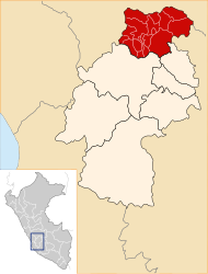
 The Daniel Hernández district is located south-central in the Tayacaja province (marked in red) |
|
| Basic data | |
| Country | Peru |
| region | Huancavelica |
| province | Tayacaja |
| Seat | Mariscal Cáceres |
| surface | 105 km² |
| Residents | 9611 (2017) |
| density | 92 inhabitants per km² |
| founding | January 9, 1956 |
| ISO 3166-2 | PE-HUV |
| politics | |
| Alcalde District | Sauro Roberto Berrocal Suárez (2019-2022) |
| Political party | Movimiento Regional Agua |
Coordinates: 12 ° 23 ′ S , 74 ° 51 ′ W
The Daniel Hernández district is located in the Tayacaja Province in the Huancavelica region in southwest central Peru . The district was established on January 9, 1956. The district was named after Daniel Hernández Morillo (1856-1932), a painter from the region who was the first director of the national art academy (Escuela Nacional de Bellas Artes.) In Lima.
The district has an area of 105 km². The 2017 census counted 9,611 inhabitants. In 1993 the population was 8,285, in 2007 9,752. The district administration is located in the small town of Mariscal Cáceres, 3280 m high, with 5577 inhabitants (as of 2017). Mariscal Cáceres is an eastern suburb of the provincial capital Pampas .
Geographical location
The Daniel Hernández district is located in the Peruvian Central Cordillera, south-central in the Tayacaja Province. The Río Upamayu crosses the district in a northeastern direction and flows into the Río Mantaro in the far northeast of the district . The Río Huanchuy limits the district to the north.
The district of Daniel Hernández borders in the west on the districts Pampas and Santiago de Tucuma , in the north on the districts Huaribamba , Salcabamba and Quishuar , in the extreme northeast on the district Andaymarca , in the east on the district Colcabamba and in the extreme southeast on the district Quichuas .
Localities
In addition to the main town, the district has the following larger towns:
- Atocc (230 inhabitants)
- Chilcas (342 inhabitants)
- La Colpa (202 inhabitants)
- Paltarumi (537 inhabitants)
- Pampa Blanca (369 inhabitants)
- Rundo (384 inhabitants)
Web links
- Peru: Huancavelica region (provinces and districts) at www.citypopulation.de
- INEI Perú